MyTopo
Council Bluffs North Iowa US Topo Map
Couldn't load pickup availability
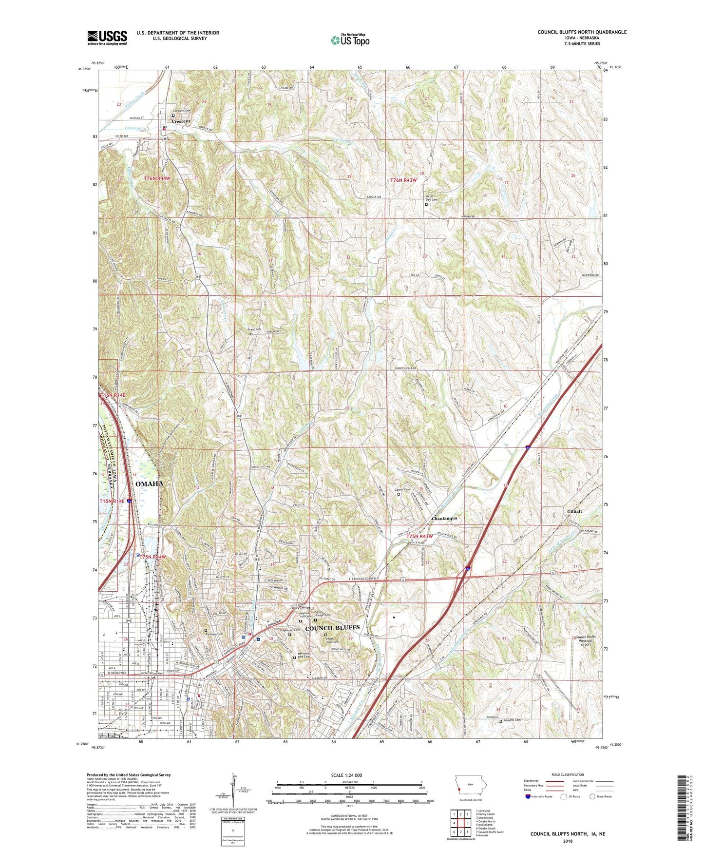
2022 topographic map quadrangle Council Bluffs North in the state of Iowa. Scale: 1:24000. Based on the newly updated USGS 7.5' US Topo map series, this map is in the following counties: Pottawattamie, Douglas. The map contains contour data, water features, and other items you are used to seeing on USGS maps, but also has updated roads and other features. This is the next generation of topographic maps. Printed on high-quality waterproof paper with UV fade-resistant inks.
Quads adjacent to this one:
West: Omaha North
Northwest: Loveland
North: Honey Creek
Northeast: Underwood
East: McClelland
Southeast: Mineola
South: Council Bluffs South
Southwest: Omaha South
Contains the following named places: Abraham Lincoln High School, Adult and Pediatric Urology Center, Alegent Health Cancer Center, Alegent Health Heart Center, Amelia House, Angel of Death Statue, Ashley Hall, August Beresheim House, Baha'i Faith Church, Bahnsen Park, Bartlett and Company Grain Elevator, Bayliss Park, Bayliss Park Fountain, Bethany Lutheran Home, Big Lake, Big Lake Park, Blockhouse Site, Bloomer Elementary School, Bluffs Ear Nose and Throat Clinic, Bluffs Family Health Care Center, Bluffs Northway, Bluffs Urological Associates Center, B'Nai Israel Synagogue, Broadway Chiropractic Clinic, Broadway Fountain, Broadway Park, Broadway Plaza, Broadway United Methodist Church, Calvary Assembly of God Church, Camp Pokamoke, Cedar Lawn Cemetery, Central Baptist Church, Changing Hearts Church, Chautauqua, CHI Health - Mercy Hospital Council Bluffs, Childrens Square USA, Christian Worship Center, Church of Christ, Church of God of Prophecy, City of Crescent, Clark Hall, Cogley Physicians Clinic, Confederate Air Force Museum, Cook Park, Council Bluffs, Council Bluffs Bible Chapel, Council Bluffs City Hall, Council Bluffs Community Hall, Council Bluffs Community Health Center, Council Bluffs Fire Department - Station 1 Headquarters, Council Bluffs Fire Department - Station 6, Council Bluffs Municipal Airport, Council Bluffs Public Library, Crescent, Crescent Cemetery, Crescent Creek, Crescent Elementary School, Crescent Post Office, Crescent Volunteer Fire and Rescue, Dialysis Center of Council Bluffs, Discovery Park, Dodge Hall, El Bethel Assembly of God Church, Emanuel Lutheran Church, Evans Cemetery, Fairmount Park, Fairview Cemetery, Fifth Avenue United Methodist Church, First Baptist Church, First Christian Church, First Church of Christ Scientist, First Congregational Church, First Presbyterian Church, Fourth District Judicial Residential Correctional Facility, Francis School, Fremont Hall, Garner Cemetery, Garner School, Gerald W Kirn Middle School, Gilliatt, Glendale Church, Glendale School, Golden Spike Mobile Home Park, Grace Presbyterian Church, Graham Park, Graybill Cemetery, Green Valley Cemetery, Gunn Elementary School, Harrison School, Harvest Temple Church of God, Hazel Dell Cemetery, Hazel Dell Church, Heartland Oncology and Hematology Center, Historic General Dodge House, Historic Squirrel Cage Jail, Hoover Elementary School, Hoover Hall, Indian Hills Nursing Center, Indian Hills Park, Internal Medicine Associates Center, Iowa Western Community College, Iowana School, Jennie Edmundson Memorial Hospital, Kanesville Alternative Learning Center, Kanesville Arena, Kanesville Center, Kanesville Park, Kanesville Tabernacle and Visitor Center, KBIN-TV (Council Bluffs), Kimball Park, Kinsman Monument, Kirn Park, KKAR-AM (Bellevue), Lakeview Park, Lemen Visitor Center, Lewis and Clark Elementary School, Lewis and Clark Historical Monument, Lewis and Clark Park, Lewis Hall, Lighthouse Temple Church of the Open Bible, Lincoln Park, Lincolns Visit to Council Bluffs Historical Marker, Little Mosquito Creek, Loess Hills Nursing and Rehabilitation Center, Looft Hall, Madison School, Maintenance Building, Memorial Park Cemetery, Midland Evangelical Free Church, Midlands Dental Center, Midwest Eye Care Center, Midwest Pain Management Center, Midwest Pathology Specialists Center, Midwest Womens Health Care Center, Neurosurgical Associates Center, Omni Dental Center, Orchard Heights School, Orth Chiropractic Clinic, Our Saviors Lutheran Church, Park Land, Pioneer Travel on the Mormon Trail Historical Marker, Pottawattamie County Courthouse, Pottawattamie County Sheriff's Office, Prospect Park, Prospect Park Baptist Church, Pulmonary Medicine Specialists Center, Rainbow Dental Center, Rainbow School, Reorganized Church of Jesus Christ of Latter Day Saints, Reorganized Church of Jesus Christ of Latter Day Saints - Central Congregation, Ridge Family Practice Center, Ridgewood Cemetery, Roosevelt Elementary School, Ruth Anne Dodge Memorial, Saint Albert Catholic Elementary School, Saint Albert Catholic Junior / Senior High School, Saint John Lutheran Church, Saint Johns United Church of Christ, Saint Joseph Cemetery, Saint Marks Church, Saint Mary and Saint George Coptic Orthodox Church, Saint Patricks Catholic Church, Saint Pauls Episcopal Church, Saint Pauls Evangelical Country Church, Saint Pauls Lutheran Church, Saint Peters Church, Saint Peters School, Salvation Army Church, Scottswood Post Office, Seventh Day Adventist Church, Sherwood Church, Sherwood Plaza, Sternhill Park, Stuart Hall, Sundel Plaza, Sunnydale School, Tabernacle Baptist Church, Tinley School, Township of Garner, Township of Kane, Township of Lake, Trinity Lutheran Interparish School, Trinity United Methodist Church, Tucker Career and College Center, Valley View Church, Valley View Park, Vinland School, Walnut Hill Cemetery, Washington Elementary School, Woodland School, Woodrow Wilson Middle School, ZIP Code: 51526