MyTopo
Coffeyville West Kansas US Topo Map
Couldn't load pickup availability
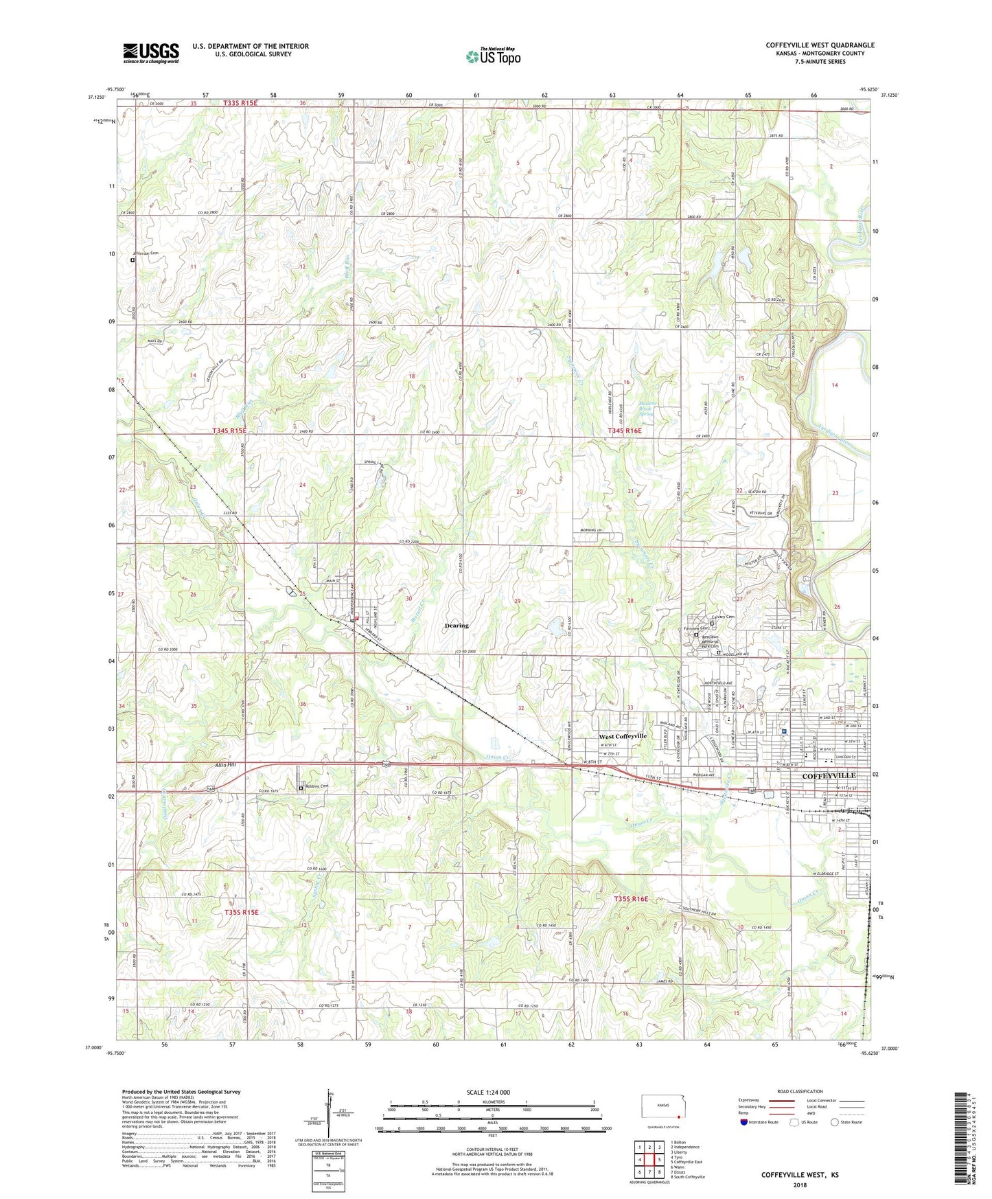
2022 topographic map quadrangle Coffeyville West in the state of Kansas. Scale: 1:24000. Based on the newly updated USGS 7.5' US Topo map series, this map is in the following counties: Montgomery. The map contains contour data, water features, and other items you are used to seeing on USGS maps, but also has updated roads and other features. This is the next generation of topographic maps. Printed on high-quality waterproof paper with UV fade-resistant inks.
Quads adjacent to this one:
West: Tyro
Northwest: Bolton
North: Independence
Northeast: Liberty
East: Coffeyville East
Southeast: South Coffeyville
South: Elliott
Southwest: Wann
This map covers the same area as the classic USGS quad with code o37095a6.
Contains the following named places: Abundant Life Temple, Allin Hill, Banks School, Bates School, Bible Baptist Church, Biscuit Creek, Bluff Run, Calvary Cemetery, Cedar Bluff Camp, Cedar Bluff School, Central Baptist Church, Central Church of the Nazarene, Church of Christ, City of Coffeyville, City of Dearing, Clear Creek School, Coffeyville Aquatic Center, Coffeyville Aviation Heritage Museum, Coffeyville City Public Works, Coffeyville Country Club, Coffeyville Fire Department, Coffeyville First Church of the Nazarene, Coffeyville Memorial Hospital Airport, Coffeyville Police Department, Coffeyville Regional Medical Center, Coffeyville Regional Medical Center Heliport, Coffeyville Seventh Day Adventist Church, Community Church, Community Elementary School, Crossroads of Community Christ, Deadman Creek, Dearing, Dearing Christian Church, Dearing City Hall, Dearing Elementary School, Dearing Post Office, Dearing Sewer Treatment Plant, East Brown School, Edgewood Elementary School, Eight Street Shopping Center, Fairview Cemetery, Fawn Creek, Field Kindley High School, First Assembly of God Church, First Church of God, First Southern Baptist Church, First United Pentecostal Church, Foster School, Fourth Street Shopping Center, Garfield Elementary School, Glendale Mobile Home Estates, Grace Fellowship Church, Hillcrest Golf Course, Indian Village, James School, Jefferson Cemetery, KKRK - FM (Coffeyville), KUSN - FM (Coffeyville), Lewark Church of God, McKinley Middle School, Meadow Brook Spring, Mid - America Revival Center Church, Montgomery County Rural Fire District Station 1 Dearing Division, New Alternative Directional Opportunities Learning Center, Parker, Pfister Park, Pierson School, Restlawn Memorial Park Cemetery, Robbins Cemetery, Robbins Grange Hall, Robbins School, Roosevelt Middle School, Spring Creek, Spring Hill Church, Spring Valley Church, Sycamore Creek, Sycamore Landing, Township of Fawn Creek, Township of Parker, Trinity United Methodist Church, Union Baptist Church, Veterans Memorial Stadium, Wesley Chapel Christian Methodist Episcopal Church, West Coffeyville, Westside Christian Church, ZIP Code: 67340