MyTopo
Iola Kansas US Topo Map
Couldn't load pickup availability
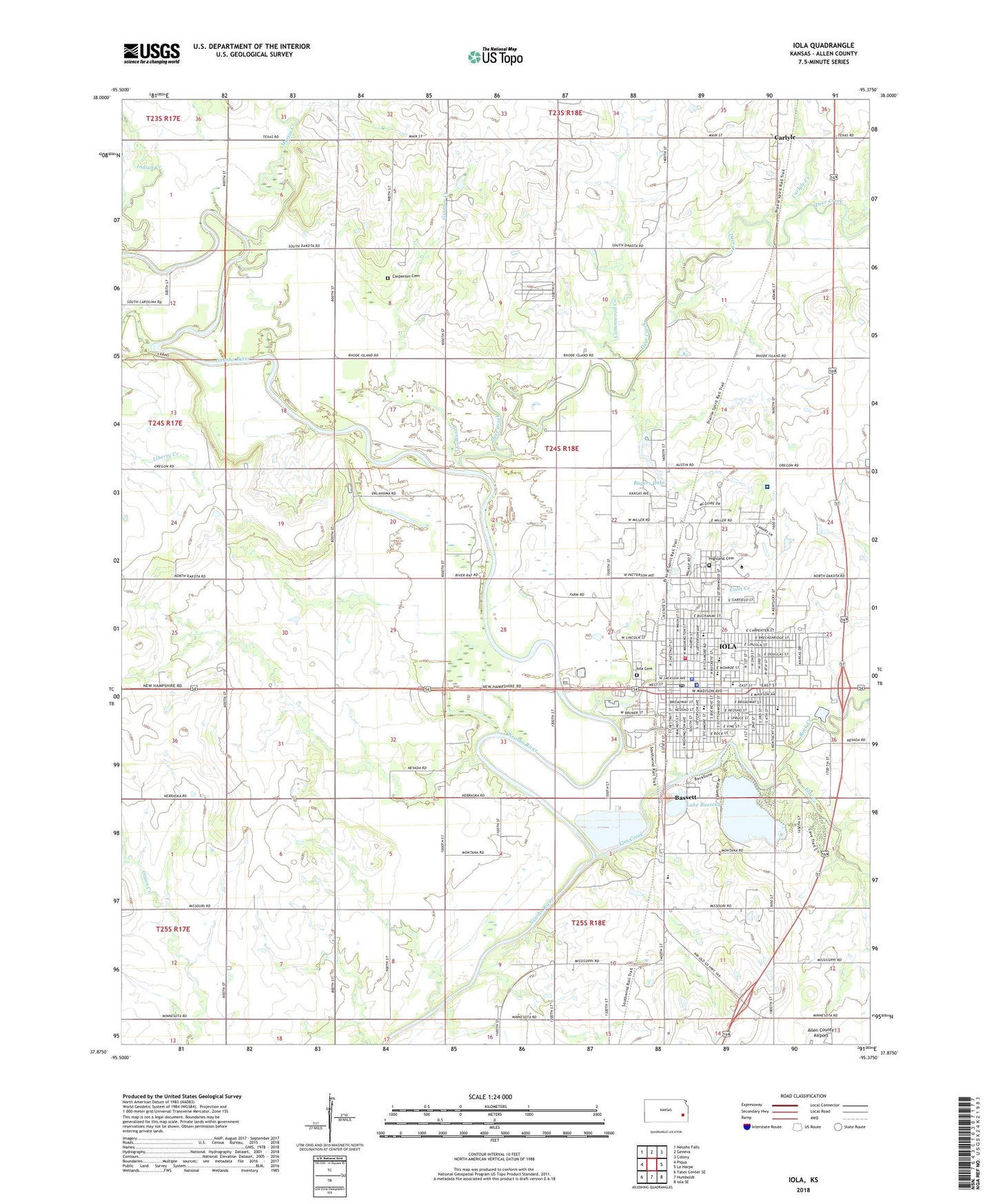
2022 topographic map quadrangle Iola in the state of Kansas. Scale: 1:24000. Based on the newly updated USGS 7.5' US Topo map series, this map is in the following counties: Allen. The map contains contour data, water features, and other items you are used to seeing on USGS maps, but also has updated roads and other features. This is the next generation of topographic maps. Printed on high-quality waterproof paper with UV fade-resistant inks.
Quads adjacent to this one:
West: Piqua
Northwest: Neosho Falls
North: Geneva
Northeast: Colony
East: La Harpe
Southeast: Iola SE
South: Humboldt
Southwest: Yates Center SE
This map covers the same area as the classic USGS quad with code o37095h4.
Contains the following named places: Allen Community College, Allen County Courthouse, Allen County Emergency Medical Services Headquarters, Allen County Fairgrounds, Allen County Historical Society and Museum, Allen County Hospital Airport, Allen County Jail, Allen County Regional Hospital, Allen County Sheriff's Office, Bassett, Bible Baptist Church, Boyers Lake, Calvary United Methodist Church, Carlyle, Carlyle Creek, Carlyle Presbyterian Church, Carpenter Cemetery, Carpenter School, Cedarbrook Golf Course, Church of God, City of Bassett, City of Iola, Community Baptist Church, Coon Creek, Cottonwood Creek, Covenant of Faith Christian Center, Crossroads Alternative School, Deer Creek, Elm Creek, Eukeway, Fellowship Regional Church, First Baptist Church, First Church of Christ Scientist, First Church of the Nazarene, First Presbyterian Church, Fredonia, Free Methodist Church, Garfield Park, Grace Lutheran Church, Grace Southern Baptist Church, Greaser Creek, Harvest Baptist Church, Harvest Time Fellowship, Highland Cemetery, Horville School, Iola, Iola Area Community Christian School, Iola Baptist Temple, Iola Cemetery, Iola Church of Christ, Iola City Hall, Iola Emergency Medical Services, Iola Fire Department, Iola First Assembly of God, Iola First Christian Church, Iola High School, Iola Memorial Hall, Iola Middle School, Iola Police Department, Iola Post Office, Iola Public Library, Iola Seventh Day Adventist Church, Iola Water Treatment Plant, Jefferson Elementary School, Kansas Department of Transportation Area 41 Shop, Kansas Highway Patrol Troop H Iola, KIKS-AM (Iola), KIOL-FM (Iola), Lake Bassola, Lake Bassola Dam, Liberty Creek, Lincoln Elementary School, Major General Frederick Funston Boyhood Home, Martin Creek, McKinley Elementary School, North Community Building, North Industrial Site Number 1, North Industrial Site Number 2, North Industrial Site Number 3, North Maple Grove School, North Shopping Center, Old Jail Museum, Plaza Shopping Center, Prairie Dell School, Riverside Park, Rivertree Christian Church, Rock Creek, Saint John's Roman Catholic Church, Saint Johns School, Saint Timothy's Episcopal Church, Salem United Methodist Church, Second Baptist Church, Southeast Kansas Multi - County Health Department Allen County, The Baptist Temple, The Church of Jesus Christ of Latter Day Saints, Township of Carlyle, Township of Geneva, Township of Iola, Trinity United Methodist Church, Truth Pentecostal Church, Union School, United Brethren Church, Ward Chapel African Methodist Episcopal Church, Wesley United Methodist Church, West Neosho School, Womack Airport, ZIP Code: 66749