MyTopo
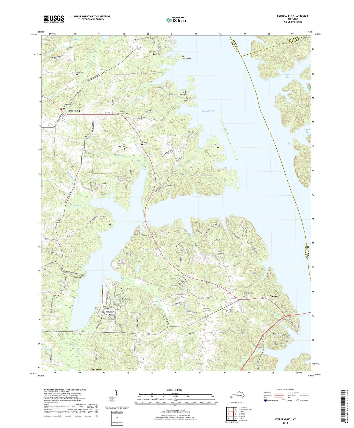
Fairdealing Kentucky US Topo Map
Couldn't load pickup availability
Also explore the Fairdealing Forest Service Topo of this same quad for updated USFS data
2022 topographic map quadrangle Fairdealing in the state of Kentucky. Scale: 1:24000. Based on the newly updated USGS 7.5' US Topo map series, this map is in the following counties: Marshall, Trigg, Lyon. The map contains contour data, water features, and other items you are used to seeing on USGS maps, but also has updated roads and other features. This is the next generation of topographic maps. Printed on high-quality waterproof paper with UV fade-resistant inks.
Quads adjacent to this one:
West: Hardin
Northwest: Briensburg
North: Birmingham Point
Northeast: Mont
East: Fenton
Southeast: Rushing Bay
South: Hico
Southwest: Dexter
This map covers the same area as the classic USGS quad with code o36088g2.
Contains the following named places: Aston Cemetery, Aurora, Aurora Ross Fire Station, Aurora School, Barnett Cemetery, Bee Creek, Billie Branch, Cap Spring, Clear Creek, Collie Cemetery, Cool Creek, Fairdealing, Fairdealing - Olive Fire Station, Fairdealing Cemetery, Fairdealing Division, Ferguson Spring Church, Ferguson Springs Cemetery, Four Rivers Boy Scout Reservation, Gregory Cemetery, Henson Cemetery, Hiatt Cemetery, Higgins Bay, Howard Cemetery, Jonathan Creek, Jonathan Creek Cabin Area, Jonathan Elementary School, Ledbetter Creek, Maple Methodist Church, Maple Spring Branch, Maple Spring Cemetery, McClain Branch, McLoad Cemetery, Neale Branch, Olive Branch, Page Cemetery, Pirates Cove Airport, Pleasant Hope Missionary Baptist Church, Price Cemetery, Ruff Creek, Ruff Creek Cabin Area, Ruff Creek Cemetery, Saint Henry Catholic Cemetery, Sugar Bay, Terrapin Branch, Union Ridge, Union Ridge Baptist Church, Union Ridge Cemetery, Unity, Unity Branch, Unity Cumberland Presbyterian Church, Unity School, West Fork Bee Creek, West Fork Ruff Creek, Widow Reynolds Bar Post Light, Wolf Branch, WVHM-FM (Benton), Wyatt Cemetery, ZIP Code: 42048