MyTopo
McDowell Kentucky US Topo Map
Couldn't load pickup availability
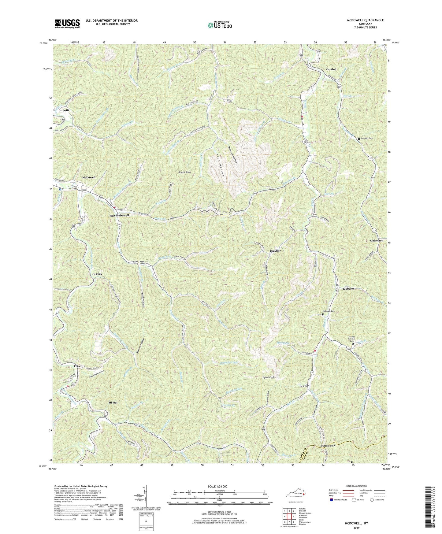
2022 topographic map quadrangle McDowell in the state of Kentucky. Scale: 1:24000. Based on the newly updated USGS 7.5' US Topo map series, this map is in the following counties: Floyd, Pike. The map contains contour data, water features, and other items you are used to seeing on USGS maps, but also has updated roads and other features. This is the next generation of topographic maps. Printed on high-quality waterproof paper with UV fade-resistant inks.
Quads adjacent to this one:
West: Wayland
Northwest: Martin
North: Harold
Northeast: Broad Bottom
East: Pikeville
Southeast: Dorton
South: Wheelwright
Southwest: Kite
This map covers the same area as the classic USGS quad with code o37082d6.
Contains the following named places: Akers Branch, Andy Branch, Antioch School, Beaver, Biglick Branch, Border Railroad Station, Branham Creek, Bryant Branch, Bryant Branch School, Buckhorn Fork, Buckhorn Hollow, Buzzard Rock, Church of Christ at Galveston, Church of God of Prophecy, Clear Creek, Clear Creek Church, Clear Creek School, Craynor, Deal Branch, Doty Branch, Drift, Drift Presbyterian Church, Dry Branch, East McDowell, Elliott Chapel, Emmanuel Full Gospel Church, First Baptist Church, Frasure Branch, Frasure Branch School, Frasure Creek, Frozen Creek, Galveston, Galveston Post Office, Gap Fork, Gearhart School, Gearheart Branch, Grethel, Grethel Church, Grethel Post Office, Grethel-Teaberry Division, Hall Fork, Hall School, Hamilton Branch, Hays Branch, Head of Frasure Creek School, Head of Little Mud School, Hi Hat, Hi Hat Post Office, Hollybush Cemetery, Hoods Fork, Hopkins Branch, Indian Grave Hollow, Lambert School, Lambert Station, Lee Alley Cemetery, Lee Alley School, Left Beaver Volunteer Fire and Rescue, Left Beaver Volunteer Fire Department and Rescue Squad Station 2, Left Fork Frasure Branch, Left Fork Hoods Fork, Left Fork Tinker Fork, Little Branch, Little Nancy Church, Little Rosa Church of Old Regular Baptist, Lower Wolfpen Branch, Margarett Fork, McDowell, Mcdowell Appalachian Regional Healthcare Hospital, McDowell Census Designated Place, McDowell Division, Middle Branch Frasure Creek, Mink Branch, Mink Branch School, Mitchell Branch, Moore Fork, Morgan Fork, Mouth of Branham Creek School, Mud Creek Lookout Tower, Mud Creek Volunteer Fire Department, Mud Creek Volunteer Fire Department Station 2, Neck Branch, Neck Branch School, Ned Fork, Ned Fork School, Newman Branch, Newsom Cemetery, Newsom Hollow, Old Primitive Baptist Church, Orkney, Osborne Branch, Pilgrim Rest Church, Pilgrims Home Church of Old Regular Baptist, Pine Grove Baptist Church, Polly Spencer Branch, Poplarlick Fork, Price, Red Morg Branch, Reynolds Branch, Rich Hollow, Right Fork Tinker Fork, Rough Branch, Rough Knob, Samaria Church, Signal Knob, Simpson Branch, Simpson Branch School, Spewing Camp Branch, Spewing Camp School, Step Branch, Stonecoal Hollow, Sturgill Branch, Sword Branch, Tackett Branch, Tackett Fork, Tackett Fork School, Teaberry, Teaberry Post Office, Teaberry School, The Little Rachel Church of Jesus Christ of Old Regular Baptist, Thomas Hamilton Cemetery, Tinker Fork, Tinker Fork School, Upper Wolfpen Branch, Will Hamilton School, Zion Church, Zion Church of Old Regular Baptist, ZIP Codes: 41604, 41619, 41631, 41635, 41636, 41647, 41660