MyTopo
Lexington West Kentucky US Topo Map
Couldn't load pickup availability
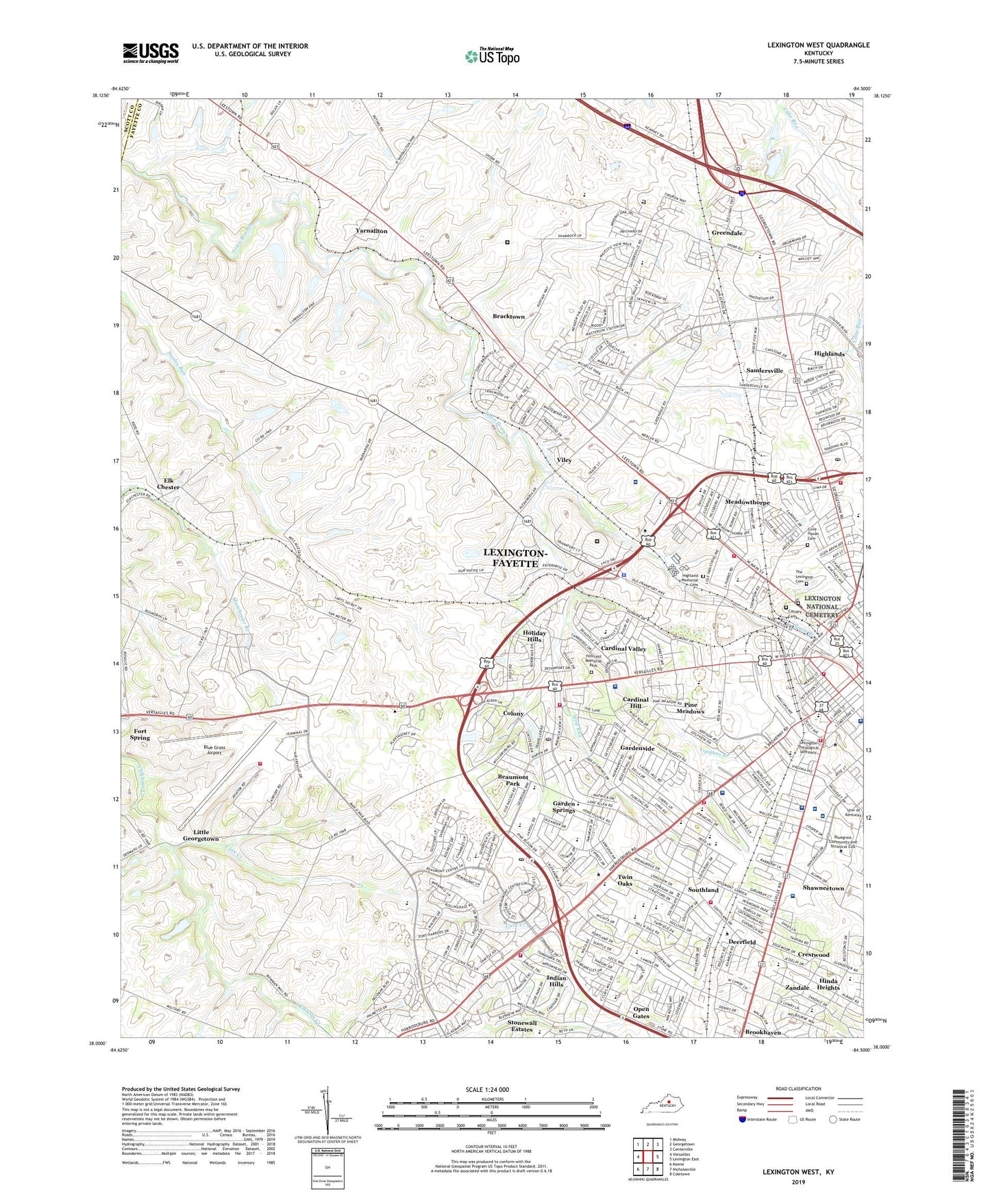
2022 topographic map quadrangle Lexington West in the state of Kentucky. Scale: 1:24000. Based on the newly updated USGS 7.5' US Topo map series, this map is in the following counties: Fayette, Scott, Woodford. The map contains contour data, water features, and other items you are used to seeing on USGS maps, but also has updated roads and other features. This is the next generation of topographic maps. Printed on high-quality waterproof paper with UV fade-resistant inks.
Quads adjacent to this one:
West: Versailles
Northwest: Midway
North: Georgetown
Northeast: Centerville
East: Lexington East
Southeast: Coletown
South: Nicholasville
Southwest: Keene
This map covers the same area as the classic USGS quad with code o38084a5.
Contains the following named places: Adam Rankin House Historical Marker, Adolph F Rupp Historical Marker, Baptist Health Lexington, Barker Hall And Buell Armory Historical Marker, Beaumont Middle School, Beaumont Park, Beaumont Post Office, Big Elm Country Club, Blackburn Correctional Institution, Blue Grass Airport, Bluegrass Airport Fire Station, Booker T Washington Montessori Magnet School, Bracktown, Brookhaven, Calvary Cemetery, Cardinal Hill, Cardinal Hill Rehabilitation Hospital, Cardinal Valley, Cardinal Valley Elementary School, Carver School, Cave Creek, Cedar Hall-Helm Place Historical Marker, Central Kentucky Area Vocational School, Clays Mill Elementary School, Colony, Colored Orphan Industrial Home Historical Marker, Cove Haven Cemetery, Crestwood, Deerfield, Douglas High School, Douglas Park, Elk Chester, Fayette-Lexington Health Center, Federal Medical Center Lexington, First Pioneer Race Course Historical Marker, Garden Springs, Garden Springs Elementary School, Gardenside, Gardenside Post Office, Glendover Elementary School, Greendale, Harrison Elementary School, Highland Memorial Cemetery, Highlands, Hillcrest Memorial Park, Hinda Heights, Holiday Hills, Indian Hills, James Lane Allen Elementary School, Jefferson Davis School, Keeneland Race Course, Kentucky Kernel Historical Marker, Lafayette High School, Leestown Middle School, Lewis and Clark Visits to Lexington Historical Marker, Lexington Cemetery Historical Marker, Lexington Clinic, Lexington Division of Police - West Sector, Lexington Fire Department Station 10, Lexington Fire Department Station 11, Lexington Fire Department Station 12, Lexington Fire Department Station 13, Lexington Fire Department Station 14, Lexington Fire Department Station 20, Lexington Fire Department Station 3, Lexington Fire Department Station 6, Lexington National Cemetery, Lexington Post Office, Lexington School, Lexington Theological Seminary, Lexington Trotting Track, Lexington Veterans Affairs Medical Center Cooper Division, Lexington Veterans Affairs Medical Center Leestown Division, Lexington-Fayette Central Division, Lexington-Fayette Southwest Division, Lincoln School, Little Georgetown, Main Building Historical Marker, Mary Queen of the Holy Rosary School, Mary Todd Lincoln House Historical Marker, Math Science and Technology Center, Matthew H Jouett Historical Marker, Meadowthorpe, Meadowthorpe Elementary School, Memorial Hall Historical Marker, Miller Hall Historical Marker, Open Gates, Patterson Hall Historical Marker, Paul Laurence Dunbar High School, Paynes, Picadome Elementary School, Pine Meadows, Pioneer Burying Ground Historical Marker, Rosa Parks Elementary School, Saint Joseph Hospital, Saint Joseph Hospital Heliport, Sandersville, School for the Creative and Performing Arts at Bluegrass, School for the Creative and Performing Arts at Lafayette, Scovell Hall Historical Marker, Shawneetown, South Elkhorn Church, Southern Hills United Methodist Church, Southland, Southside Technical Center, Spring Valley Country Club, Stonewall Elementary School, Stonewall Estates, The Academy at Lexington, The Learning Center at Linlee, The Lexington Cemetery, Thomas Satterwhite Noble Home Historical Marker, Town Branch of Elkhorn Historical Marker, Turfland Mall, Twin Oaks, University of Kentucky Agricultural Experimental Station, University of Kentucky Chandler Hospital, University of Kentucky Health Care - Good Samaritan Hospital, University of Kentucky Hospital Heliport, Van Meter, Vaughns Branch, Viley, WBKY-WUKY Historical Marker, WLXG-AM (Lexington), Wolf Run, WRFL-FM (Lexington), WTKT-FM (Georgetown), WVLK-AM (Lexington), Yarnallton, Zandale, ZIP Codes: 40503, 40504, 40506, 40508, 40510, 40513