MyTopo
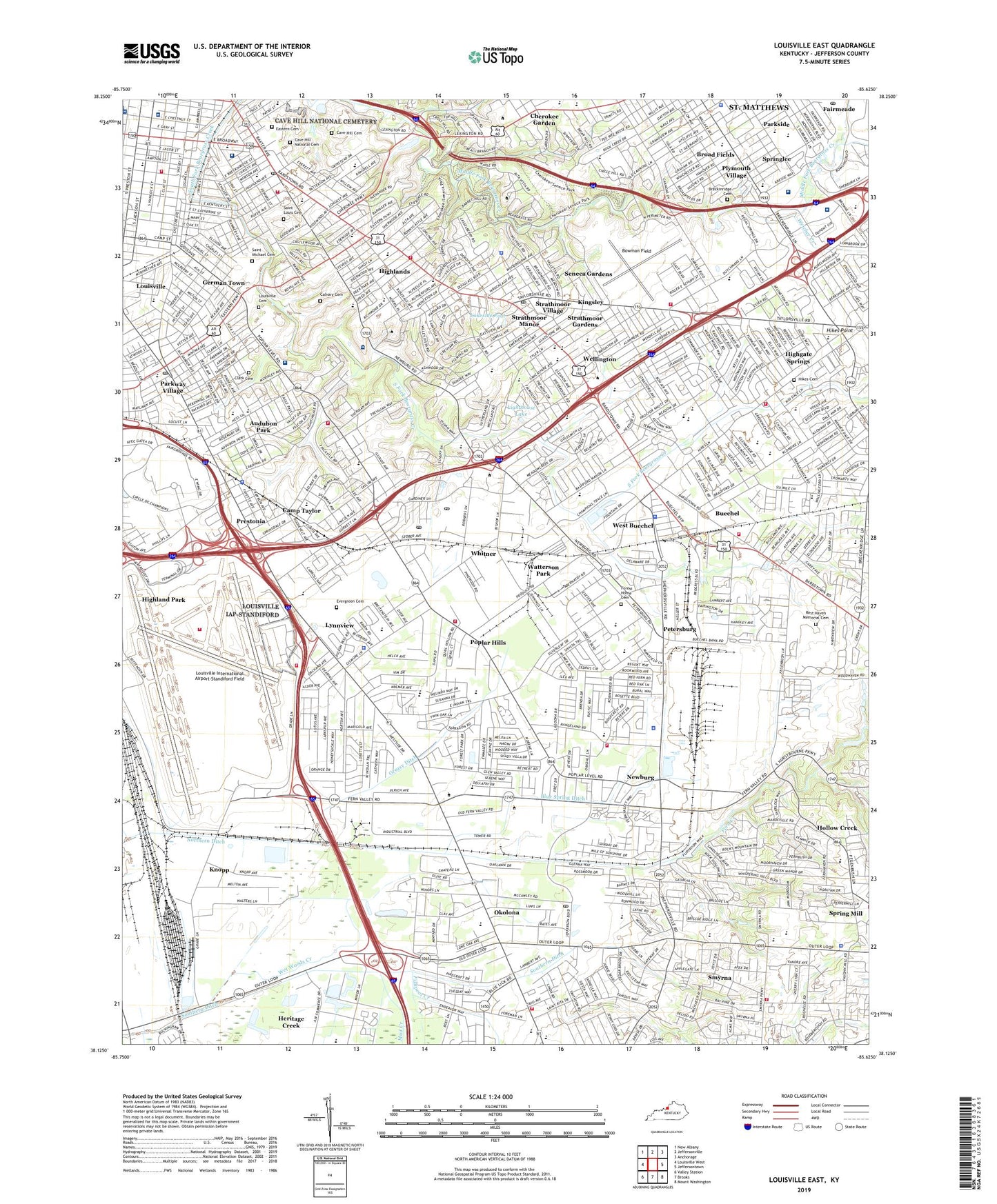
Louisville East Kentucky US Topo Map
Couldn't load pickup availability
2022 topographic map quadrangle Louisville East in the state of Kentucky. Scale: 1:24000. Based on the newly updated USGS 7.5' US Topo map series, this map is in the following counties: Jefferson. The map contains contour data, water features, and other items you are used to seeing on USGS maps, but also has updated roads and other features. This is the next generation of topographic maps. Printed on high-quality waterproof paper with UV fade-resistant inks.
Quads adjacent to this one:
West: Louisville West
Northwest: New Albany
North: Jeffersonville
Northeast: Anchorage
East: Jeffersontown
Southeast: Mount Washington
South: Brooks
Southwest: Valley Station
This map covers the same area as the classic USGS quad with code o38085b6.
Contains the following named places: Alliant Medical Pavilion, Aquinas Academy, Assumption High School, Atherton High School, Audubon Country Club, Audubon Park, Audubon School, Augustus E Willson Historical Marker, Baptist Health Louisville, Baptist Hospital East Heliport, Baptist Hospital East Home Health Agency, Bardstown Square Shopping Center, Barret Junior High School, Bashford Manor Mall Shopping Center, Bashford Manor School, Belknap School, Bellarmine University, Big Spring Country Club, Black Mudd Park, Bloom School, Blue Spring Ditch, Bluegrass Manor Shopping Center, Bon Air Estates, Bowman Field, Bowman Field East Historical Marker, Bowman Field Historical Marker, Brashford Manor Historical Marker, Breckinridge Cemetery, Broad Fields, Bruce Junior High School, Buechel, Buechel Census Designated Place, Calvary Cemetery, Camp Taylor, Camp Taylor Memorial Park, Camp Zachary Taylor Historical Marker, Cardinal Stadium, Carmichael School, Cave Hill Cemetery, Cave Hill National Cemetery, Central Jefferson Division, Cherokee Garden, Cherokee Park, City of Audubon Park, City of Audubon Park Historical Marker, City of Broad Fields, City of Fairmeade, City of Kingsley, City of Louisville, City of Lynnview, City of Meadowview Estates, City of Norbourne Estates, City of Parkway Village, City of Plymouth Village, City of Poplar Hills, City of Saint Matthews, City of Seneca Gardens, City of Spring Mill, City of Springlee, City of Strathmoor Manor, City of Strathmoor Village, City of Watterson Park, City of Wellington, City of West Buechel, Country Day School, Dahlem Center Shopping Center, Du Pont Manual Stadium, Duck Spring Branch, Durrett High School, East End Health South Surgicenter of Louisiville, Eastern Cemetery, Emerson School, Enid Yandell Historical Marker, Evergreen Cemetery and Garden Mausoleum, Fairmeade, Farmington Historical Marker, Father Herman Felhoelter Historical Marker, Fern Creek, Festival on Jefferson Court Shopping Center, Fishpool Creek, Floyds Station Historical Marker, Forest Home Cemetery, Forest Home Cemetery Historical Marker, Frazier Rehabilitation Institute of Newburg, Gardiner Lane Shopping Center, Gateway Rehabilitation Hospital, General Hospital, George Rogers Clark Historical Marker, George Rogers Clark Park, German Town, Germantown Square Shopping Center, Gilmore Lane School, Goldsmith School, Greasy Ditch, Great Clips Festival Shopping Center, Greathouse School, Green Street Baptist Church Historical Marker, Grotto and Garden of Our Lady of Lourdes Historical Marker, Guardian Angels School, Haller-Hazlett and Adams Jewish Hospital, Hartstern School, Hawthorne School, Hayfield Historical Marker, Health South Louisville Surgery Center, Highgate Springs, Highland Junior High School, Highlands, Highview Census Designated Place, Highview Park, Hikes Cemetery, Hikes Point, Hikes Point Plaza Shopping Center, Hikes School, Holiday Manor Shopping Center, Holy Family School, Indian Trail School, Indian Trail Square Shopping Center, Jefferson Central Division, Jefferson County, Jefferson Mall Shopping Center, John B Castleman Historical Marker, John Floyds Grave Historical Marker, Kentucky Fair and Exposition Center, Kindred Hospital - Louisville, Kingsley, Klondike School, Knobview Shopping Center, Knopp, Lakeside Pool, Lighthouse Lake, Longfellow School, Louisville Airport Division, Louisville Cemetery, Louisville Cemetery Historical Marker, Louisville Collegiate School, Louisville Division, Louisville Downs, Louisville East Division, Louisville International Airport-Standiford Field, Louisville Legion Historical Marker, Louisville/Jefferson County Metro Government, Louisville/Jefferson County metro government (balance), Low Dutch Station Historical Marker, Lowell School, Luhr School, Lynnview, Lynnview Shopping Center, Martin Luther School, McMahan Plaza Shopping Center, Meadowview Estates, Melbourne Heights School, Mid City Mall Shopping Center, Minors Lane School, Moore High School, Mud Creek, Mulberry Hill Cemetery, Mulberry Hill House Historical Marker, Murray Atkins Walls Historical Marker, Newburg, Newburg Census Designated Place, Newburg School, Nicola Marschall Historical Marker, Norbourne Estates, Northern Ditch, Norton Audubon Hospital, Norton Children's Hospital, Norton Women's and Children's Hospital, Okolona, Okolona Census Designated Place, Okolona Park, Old Forester Bourbon Historical Marker, Our Lady of Lourdes School, Our Lady of Peace Hospital, Parkside, Parkway Village, Petersburg, Petersburg Historical Marker, Plymouth Village, Poplar Hills, Poplar Plaza Shopping Center, Preston Park Seminary Historical Marker, Prestonia, Prestonia School, Price School, Rangeland School, Red Cross Hospital, Rest Haven Memorial Cemetery, Resurrection School, Reverend William H Sheppard Historical Marker, Rubel Avenue School, Saint Anthonys Hospital, Saint Joseph Infirmary Historical Marker, Saint Josephs Infirmary, Saint Louis Cemetery, Saint Michael Cemetery, Saint Michaels Park, Schnitzelburg Historical Marker, Seneca Gardens, Seneca Park, Shelby Park, Shelbyville Road Plaza Shopping Center, Smoketown Historical Marker, Smyrna, Southern Ditch, Spring Fort Historical Marker, Spring Mill, Springlee, Springs Station Shopping Center, Strathmoor Gardens, Strathmoor Manor, Strathmoor Village, Strawberry Yards, Trackside Louisville Shopping Center, Trough Spring House Historical Marker, Tyler Park, University Hospital Heliport, University of Louisville Hospital, Watterson Park, Weicher Creek, Wellington, West Buechel, Wet Woods Creek, Whitner, WLLV-AM (Louisville), Woodhaven Country Club, ZIP Codes: 40204, 40205, 40209, 40213, 40217, 40218, 40219, 40228, 40231, 40280