MyTopo
Anchorage Kentucky US Topo Map
Couldn't load pickup availability
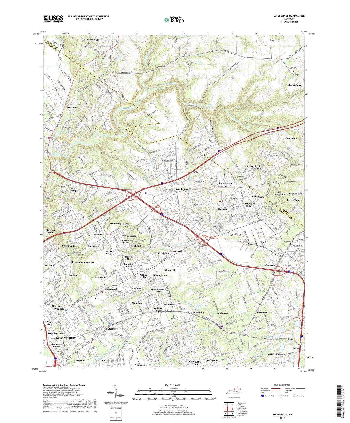
2022 topographic map quadrangle Anchorage in the state of Kentucky. Scale: 1:24000. Based on the newly updated USGS 7.5' US Topo map series, this map is in the following counties: Jefferson, Oldham. The map contains contour data, water features, and other items you are used to seeing on USGS maps, but also has updated roads and other features. This is the next generation of topographic maps. Printed on high-quality waterproof paper with UV fade-resistant inks.
Quads adjacent to this one:
West: Jeffersonville
Northwest: Charlestown
North: Owen
Northeast: La Grange
East: Crestwood
Southeast: Fisherville
South: Jeffersontown
Southwest: Louisville East
This map covers the same area as the classic USGS quad with code o38085c5.
Contains the following named places: Anchorage, Anchorage Middletown Fire Department, Anchorage Police Department, Anchorage Post Office, Anchorage Presbyterian Church, Audubon Youth Development Center, Avish Gardens Shopping Center, Ballard Memorial High School, Ballardsville, Bancroft, Barbourmeade, Bellemeade, Bellewood Presbyterian Home for Children, Berrytown, Berrytown Cemetery Historical Marker, Berrytown Historical Marker, Bethel Baptist Church, Beulah Land Bible Baptist Church, Bowen Elementary School, Briarwood, Broeck Pointe, Brownsboro Church, Brownsboro Farm, Camelot Shopping Center, Central State Hospital, Chamberlain Pointe Shopping Center, Church of God of Middletown, Church of the Epiphany, City of Anchorage, City of Bancroft, City of Barbourmeade, City of Bellemeade, City of Briarwood, City of Broeck Pointe, City of Brownsboro Farm, City of Coldstream, City of Creekside, City of Fincastle, City of Goose Creek, City of Graymoor-Devondale, City of Green Spring, City of Hickory Hill, City of Hills and Dales, City of Keeneland, City of Langdon Place, City of Lyndon, City of Manor Creek, City of Meadow Vale, City of Meadowbrook Farm, City of Moorland, City of Murray Hill, City of Norwood, City of Old Brownsboro Place, City of Orchard Grass Hills, City of Plantation, City of Prospect, City of River Bluff, City of Rolling Hills, City of Spring Valley, City of Ten Broeck, City of Westwood, City of Whipps Millgate, City of Worthington Hills, Coldstream, Cow Lake, Creekside, E P Tom Sawyer State Park, East Jefferson Division, Episcopal Church Home, Fincastle, First Baptist Church of Anchorage, Fraziertown, Freys Hill, Grace Evangelical Free Church, Graymoor - Devondale Police Department, Graymoor-Devondale, Green Spring, Greencastle Baptist Church, Griffytown, Griffytown Historical Marker, Griffytown School, Harrods Creek Baptist Church, Harrods Creek Cemetery, Harrods Creek Fire Department Station 1, Harrods Creek Historical Marker, Hickory Hill, Hillcrest, Hillcrest Baptist Church, Hills and Dales, Hite Creek, Hite Creek Wastewater Treatment Plant, Hobbs Chapel Memorial Methodist Church, Hope Lutheran Church, Hounz Lane County Park, Hunting Creek Country Club, Isaac Hites Home Site Historical Marker, Isaac Shelby Campus University of Louisville, Jaeger Preschool, Jefferson Northeast Division, Jefferson Vocational School, John Knox Presbyterian Church, Kammerer Middle School, Keeneland, Kentucky Country Day School, Kentucky Health Care Training Institute, Kentucky Military Institute, Kingdom Hall of Jehovahs Witnesses, Lake Louisvilla, Lake Louisvilla Church, Lakeland, Langdon Place, Louisville Day Treatment Center Alternative School, Louisville Memorial Gardens and Funeral Home East, Lyndon, Lyndon Baptist Church, Lyndon Christian Church, Lyndon Fire Department Station 1, Lyndon Fire Department Station 2, Lyndon Fire Protection District Heliport, Lyndon Historical Marker, Lyndon Post Office, Lynnwood Treatment Center, Malcolm B Chancey Junior Elementary School, Manor Creek, Maryhurst Alternative School, Meadow Vale, Meadowbrook Farm, Meadowvale Police Department, Middletown Fire Department Station 3, Moorland, Mother of Good Counsel Parrish Center, Mother of Good Counsel School, Murray Hill, New Life Church, Northeast Christian Church, Northeast Jefferson Division, Norton Intermediate Health Care Center, Norton School, Norwood, O'Bannon, Old Brownsboro Crossing Shopping Center, Old Brownsboro Place, Orchard Grass Hills, Ormsby Village State Reservation, Owl Creek Country Club, Pewee Valley Division, Pilgrim Missionary Baptist Church, Plantation, Prospect, Prospect Police Department, Prospect Post Office, Prospect Village Shopping Center, Putneys Pond, River Bluff, Rolling Hills, Rolling Hills Shopping Center, Saint Albert the Greats School, Saint Francis Church, Saint Lukes Chapel, Saint Lukes Episcopal Church, Saint Margaret Mary Church, Saint Margaret Marys School, Saint Mark Old Roman Catholic Church, Saint Thomas Episcopal Church, Saint Thomas Orphanage, Saint Thomas Seminary, Shops at Forest Springs, Sleepy Hollow Lake, South Fork Harrods Creek, Spring Valley, Springdale, Springdale Community Church, Springdale Presbyterian Church, Springhurst Towne Center Shopping Center, Standard Country Club, Stutz Field, Suburban Christian Church Preschool and Kindergarten, Sycamore Chapel Methodist Church, Taylortown African Methodist Episcopal Zion Church, Ten Broeck, Ten Broeck Hospital, The Summit Shopping Center, Trinity Chapel Assembly of God Church, Victory Worship Center, Warwick Villa, Watkins United Methodist Church, Westport Alternative High School, Westport Branch Library Louisville Free Public Library, Westport Road Baptist Church, Westport Road High School, Westport Traditional Middle School and Fine Arts Academy, Westwood, Whipps Millgate, Wilder School, Willow Lake, Wolf Pen Branch, Worthington, Worthington Church of Christ, Worthington Fire Department Station 2, Worthington Fire Department Station 3, Worthington Hills, Zachary Taylor Elementary School, Zachary Taylor School, ZIP Codes: 40059, 40222, 40223, 40241, 40242