MyTopo
Jeffersonville Indiana US Topo Map
Couldn't load pickup availability
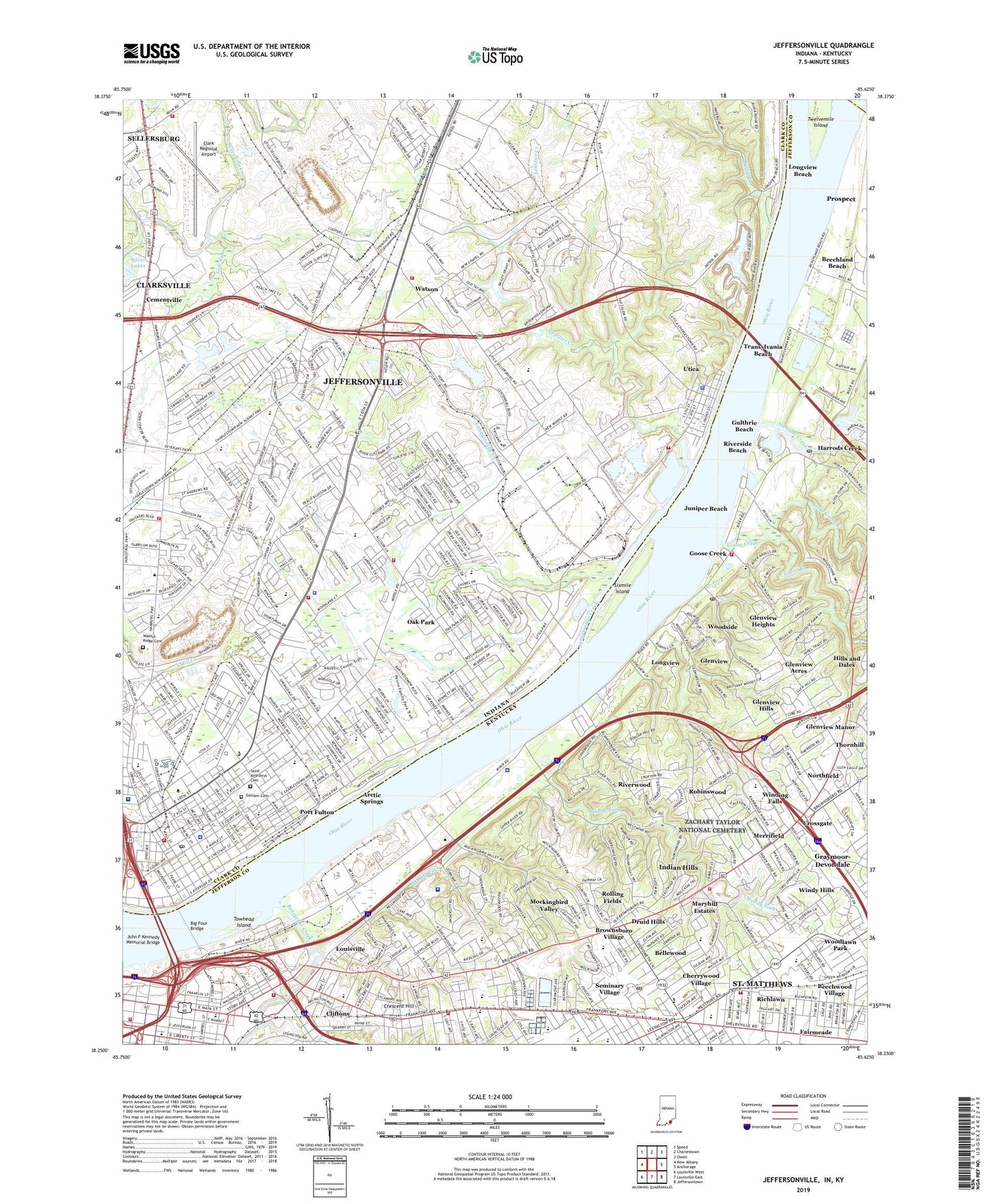
2022 topographic map quadrangle Jeffersonville in the states of Indiana, Kentucky. Scale: 1:24000. Based on the newly updated USGS 7.5' US Topo map series, this map is in the following counties: Clark, Jefferson, Oldham. The map contains contour data, water features, and other items you are used to seeing on USGS maps, but also has updated roads and other features. This is the next generation of topographic maps. Printed on high-quality waterproof paper with UV fade-resistant inks.
Quads adjacent to this one:
West: New Albany
Northwest: Speed
North: Charlestown
Northeast: Owen
East: Anchorage
Southeast: Jeffersontown
South: Louisville East
Southwest: Louisville West
Contains the following named places: Alice Virginia Coffin Historical Marker, Arctic Springs, Asbury Chapel, Bandman Park, Battle Creek, Beargrass Baptist Church Historical Marker, Beargrass Creek, Beechland Beach, Beechland Historical Marker, Beechwood Village, Bellewood, Big Drain, Big Four Bridge, Bingman Memorial Park, Breckinridge-Franklin Elementary School, Brick House Pond, Bridgepoint Elementary School, Broadway Baptist Church, Brownsboro Center Shopping Center, Brownsboro Village, Cable Baptist Church, Callahan Museum, Calvin Church, Carrie Gaulbert Cox Park, Cementville, Chenoweth School, Chenoweth Square Shopping Center, Cherrywood Village, Christ Church, Christ Church Preschool, Christ Church United Methodist Church, Church of Christ of Birchwood Avenue, City of Beechwood Village, City of Bellewood, City of Brownsboro Village, City of Cherrywood Village, City of Crossgate, City of Druid Hills, City of Glenview, City of Glenview Hills, City of Glenview Manor, City of Indian Hills, City of Jeffersonville, City of Maryhill Estates, City of Mockingbird Valley, City of Northfield, City of Richlawn, City of Riverwood, City of Rolling Fields, City of Thornhill, City of Windy Hills, City of Woodlawn Park, Clark County Sheriff's Office, Clark Memorial Hospital, Clark Regional Airport, Clifton Baptist Church, Clifton Christian Church, Clifton Heights Baptist Church, Clifton Heights Church, Cliftons, Corden Porter Education Center, Covenant Community Church, Crescent Hill, Crescent Hill Branch Library Louisville Free Public Library, Crossgate, Druid Hills, Dunn Elementary School, Early Blacksmith Shop Historical Marker, Early Jewish Congregations Historical Marker, Eastern Cemetery, Eastern Hights Chapel, Eastgate Shopping Center, Eastlawn Elementary School, Elks Country Club, Ewing Lane Elementary School, Fairview Elementary School, Faith Church, Field School, Frazier Rehabilitation Institute East, Galen College of Nursing, Glenview, Glenview Acres, Glenview Heights, Glenview Hills, Glenview Manor, Glenview Pointe Shopping Center, Glenview Post Office, Goose Creek, Gulthrie Beach, Harrods Creek, Harrods Creek Fire Department Station 2, Harrods Creek Post Office, Holy Trinity School, Home of the Innocents Elementary School, Home of the Innocents High School, Indian Hills, Indian Hills Cherokee Section, Indian Hills Police Department, Indiana University Center, Jeffersonville, Jeffersonville City Fire Department, Jeffersonville City Fire Department Station 2, Jeffersonville City Fire Department Station 3, Jeffersonville Fire Department, Jeffersonville Fire Department Station 1, Jeffersonville High School, Jeffersonville Police Department, Jeffersonville Post Office, John F Kennedy Memorial Bridge, Juniper Beach, Kentucky Habitat For Humanity, Kentucky School for the Blind Historical Marker, Lancassange Creek, Lentzier Creek, Liberty Plaza Shopping Center, Lick Run, Lincoln Elementary School, Little Goose Creek, Locust Grove Historical Home, Locust Grove Historical Marker, Locust Grove House Historical Marker, Longview, Longview Beach, Louisville Country Club, Louisville Fire Department Engine 4, Louisville Fire Engine Company 21, Louisville Fire Station Engine 5, Louisville Slugger Field, Louisville Veterans Affairs Medical Center, Maple Elementary School, Maryhill Estates, Masonic Home Post Office, McCulloch Volunteer Fire Department, Memorial Park, Meriwether House Historical Marker, Merker School, Merrifield, Middle Fork Beargrass Creek, Middle Road School, Mockingbird Valley, Muddy Fork, New Chapel, New Chapel Emergency Medical Services, Northaven Elementary School, Northfield, Northside Church, Oak Park, Oak Park Census Designated Place, Oak Park Church, Ottawa University Indiana Campus, Park Place Church, Parkview Junior High School, Pleasant Run, Poiema Bible Institute, Pond Creek, Port Fulton, Richlawn, Rise and Shine Child Care Center, River City Park, River Road Country Club, Riverside Beach, Riverside Elementary School, Riverwood, Robinswood, Rolling Fields, Rolling Fields Church, Rose Hill Elementary School, Sacred Heart Home, Sacred Heart of Jesus School, Saint Anthonys Cemetery, Saint Boniface School, Saint Frances of Rome School, Saint Johns Evangelical Church Historical Marker, Saint Josephs Orphanage, Saint Leonards School, Saint Matthews, Saint Matthews Fire and Rescue Station 2, Saint Matthews Fire Protection Station 1, Saint Matthews Pavilion Shopping Center, Saint Matthews Station Shopping Center, Sellersburg Fire Department Station 4 Clark County Airport, Seminary Village, Sevastopol School, Silver Lakes, Sixmile Island, South Fork Beargrass Creek, Spring Hill Elementary School, Stivers School, Sylvan Park, The Chance School, Thomas Edison Butchertown House Historical Marker, Thomas Jefferson Elementary School, Thornhill, Thruston Park, Towhead Island, Town of Utica, Township of Jeffersonville, Township of Utica, Trader Baker Mall, Transylvania Beach, Trinity Church, Twin Park, University of Louisville Potamological Institution, Utica, Utica Police Department, Utica Township Volunteer Fire Department Station 1, Utica Township Volunteer Fire Department Station 2, Van Dyke Park, W E Wilson Elementary School, Walnut Ridge Cemetery, Washington School, Water Works Pumping Station Historical Marker, Wathen Park, Watson, WAVG-AM (Louisville), Webster University Graduate Center, Wellstone Regional Hospital, WFIA-AM (Louisville), Winding Falls, Windy Hills, WLKY-TV Studios Heliport, Woodlawn Park, Woodlawn Race Course Historical Marker, Woodside, WRKA-FM (Saint Matthews), WTMT-AM (Louisville), Yellow Ambulance Service, Zachary Taylor Home Historical Marker, Zachary Taylor National Cemetery, Zachary Taylor National Cemetery Historical Marker, ZIP Codes: 40025, 40041, 40206, 40207, 47130