MyTopo
Abbeville West Louisiana US Topo Map
Couldn't load pickup availability
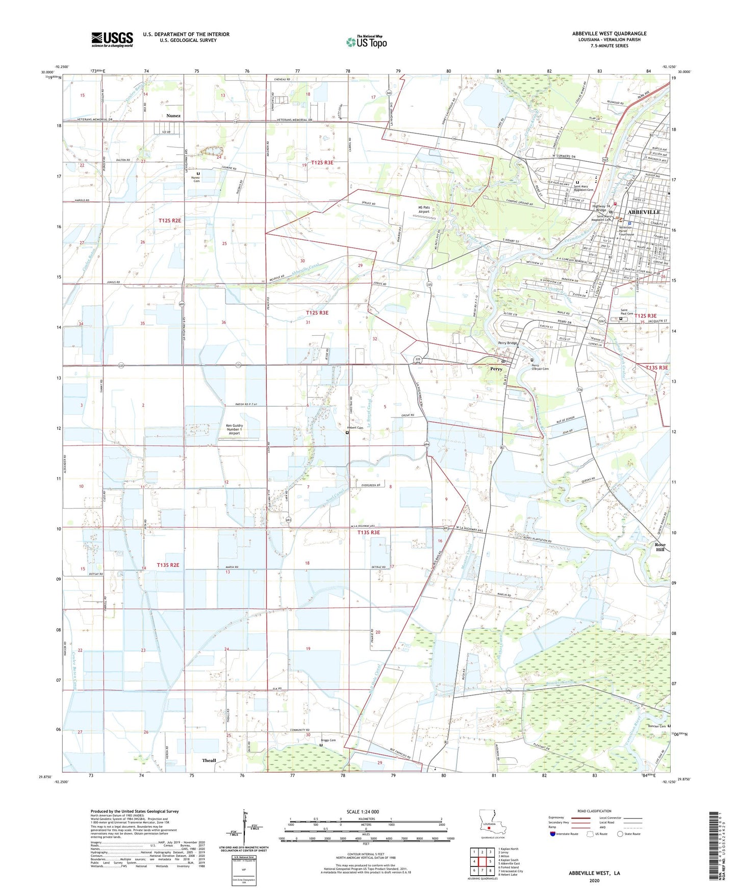
2024 topographic map quadrangle Abbeville West in the state of Louisiana. Scale: 1:24000. Based on the newly updated USGS 7.5' US Topo map series, this map is in the following counties: Vermilion. The map contains contour data, water features, and other items you are used to seeing on USGS maps, but also has updated roads and other features. This is the next generation of topographic maps. Printed on high-quality waterproof paper with UV fade-resistant inks.
Quads adjacent to this one:
West: Kaplan South
Northwest: Kaplan North
North: Leroy
Northeast: Milton
East: Abbeville East
Southeast: Hebert Lake
South: Intracoastal City
Southwest: Forked Island
This map covers the same area as the classic USGS quad with code o29092h2.
Contains the following named places: Abbeville, Abbeville Canal, Abbeville Church of Christ, Abbeville City Hall, Abbeville Commercial Historic District, Abbeville Country Club, Abbeville Cultural and Historical Alliance, Abbeville Fire Department, Abbeville Oil and Gas Field, Abbeville Police Department, Abbeville Police Department - Chief, Abbeville Residential Historic District, Abbeville United Methodist Church, Abbeville's Greater Church, Bancker Canal, Bancker Cemetery, Bancker Ferry, Bill Canal, Briggs Cemetery, Briggs Chapel, Broussard Canal, Bull Hole Canal, Church of God, City of Abbeville, Comeaux Park, Comeaux Sanitarium, Coulee Baton, Coulee Galleque, Coulee Kenny, Cow Island Number Two Canal, Eaton Park Elementary School, Faulk Canal, First Baptist Church, First Presbyterian Church, Gastinel Canal, Harrington Flying Service Airport, Hebert Canal, Hebert Cemetery, Highway 14 Bridge, Holmes Canal, J and L Mobile Home Park, Ken Guidry Number 1 Airport, Le Boeuf Canal, Louisiana State University AgCenter Vermillion Parish Office, Louisiana Technical College Gulf Area Campus, Macedonia Baptist Church, Magdalen Square, Mount Carmel Convent, Mount Carmel School, Mount Triumph Baptist Church, Mouton Canal, Mouton Cove, Mouton Landing Strip, MS Pats Airport, Noel Canal, Nunez, Nunez Cemetery, Our Lady of Lourdes Roman Catholic Church, Our Lady of Lourdes School, Palms Sanitarium, Parish Governing Authority District 4, Parish Governing Authority District 5, Perry, Perry Bridge, Perry Census Designated Place, Perry Gas Field, Perry High School, Perry O'Bryan Cemetery, Perry Post Office, Pleasant Green Baptist Church, Pleasant Grove Church, Rose Hill, Saint James Church, Saint Mary Magdalen Catholic Church, Saint Mary Magdalen Cemetery, Saint Marys Congregational Church, Saint Paul Cemetery, Saint Pauls Episcopal Church, Schriefer Airstrip, Seventh Ward Elementary School, Sorbet Canal, Special Education School, Theall, Tiffany Plaza Shopping Center, Valcourt Coulee, Vermilion Catholic High School, Vermilion Full Gospel Tabernacle, Vermilion Health Care Center, Vermilion Parish Courthouse, Vermilion Parish Library, Vermilion Parish Police Jury, Vermilion Parish Sheriff's Office Administration, Vermilion Parish Sheriff's Office Criminal Investigations Division, Ward Three, Williams Canal, ZIP Codes: 70510, 70575