MyTopo
Crowley East Louisiana US Topo Map
Couldn't load pickup availability
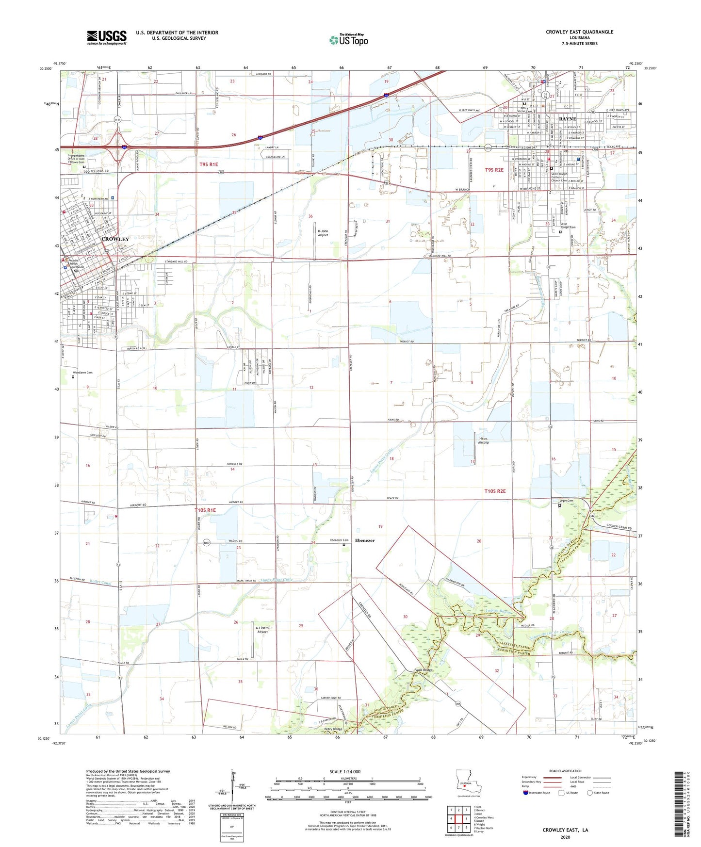
2024 topographic map quadrangle Crowley East in the state of Louisiana. Scale: 1:24000. Based on the newly updated USGS 7.5' US Topo map series, this map is in the following counties: Acadia, Vermilion, Lafayette. The map contains contour data, water features, and other items you are used to seeing on USGS maps, but also has updated roads and other features. This is the next generation of topographic maps. Printed on high-quality waterproof paper with UV fade-resistant inks.
Quads adjacent to this one:
West: Crowley West
Northwest: Iota
North: Branch
Northeast: Mire
East: Duson
Southeast: Leroy
South: Kaplan North
Southwest: Wright
This map covers the same area as the classic USGS quad with code o30092b3.
Contains the following named places: A J Patrol Airport, Acadia General Hospital, Acadia Parish Courthouse, Acadia Parish Fire Protection District 8, Acadia Parish Fire Protection District 9 - North Substation, Acadia Parish Office, Acadia Parish Police Jury, Acadia Parish Police Jury Barn, Acadia Parish Sheriff's Department - Finance, Acadia Parish Sheriff's Department - Tax Collector, Acadia Rehabilitation Hospital, Acadiana Cathedral, Acadiana Christian Fellowship Church, American Legion Hospital Heliport, Armstrong Middle School, Bible Missionary Church, Bicentennial Park, Camelot Place, Centenary United Methodist Church, Central Rayne Kindergarten School, Church of Christ in Crowley, City of Rayne, Crowley, Crowley Canal, Crowley City Hall, Crowley Fire Department, Crowley Fire Department Station 2, Crowley Fire Department Sub Station 2, Crowley Historic District, Crowley Oil and Gas Field, Crowley Police Department, Crowley Post Office, Crowley Rehabilitation Hospital, Crowley Town Club, Crowley-Rayne Industrial Park, Cunningham Christian Methodist Episcopal Church, Ebenezer, Ebenezer Cemetery, Ebenezer Church, Ebenezer School, Ebenezer United Methodist Church, Edwards Park, Faulk Bridge, First Assembly of God Church, First Baptist Church, First Presbyterian Church, First United Methodist Church, Gossen Memorial Park, Hains Airstrip, Hebron Church, Immaculate Heart of Mary Catholic Church, Independent Order of Odd Fellows Cemetery, Indian Bayou, J and K Hope Center, Kingdom Hall of Jehovahs Witnesses, K-John Airport, KSIG-AM (Crowley), Leaps and Bounds Day Care Center, Leger Cemetery, Leleux Fire Station, Levy Park, Louisiana State University Experiment Station, Louisiana State University Rice Research Center, Martin Petitjean Elementary School, Mauboles Park, Mercy Shrine Cemetery, Mermentau Prairie, Northside Assembly of God Church, Northside Christian School, Northside Community Center, Notre Dame Catholic High School, Our Mother of Mercy Catholic Church, Our Mother of Mercy Rayne Head Start School, Parish Governing Authority District 4, Parish Governing Authority District 9, Perry Point Oil and Gas Field, Perry Point School, Petry Bridge, Rayne, Rayne Branch Library, Rayne Catholic Elementary School, Rayne Church of God in Christ, Rayne City Hall, Rayne Civic Center, Rayne Greater First Apostolic Church, Rayne High School, Rayne Police Department, Rayne Post Office, Rayne Volunteer Fire Department, Rayne Water Treatment Facility, Rayne-Branch Hospital, Redemptorist Catholic School, Roller Canal, Saint Joseph Catholic Church, Saint Joseph Catholic Church Cemetery, Saint Joseph Cemetery, Saint Matthews Baptist Church, Saint Michael Catholic School, Saint Michaels Catholic Church, South Crowley Elementary School, South Rayne Elementary School, Southside Community Center, Southwind Assisted Living Facility, Southwind Nursing and Rehabilitation Center, Starlight Baptist Church, Ward One, Wesley United Methodist Church, Woodlawn Cemetery, ZIP Code: 70578