MyTopo
Ville Platte Louisiana US Topo Map
Couldn't load pickup availability
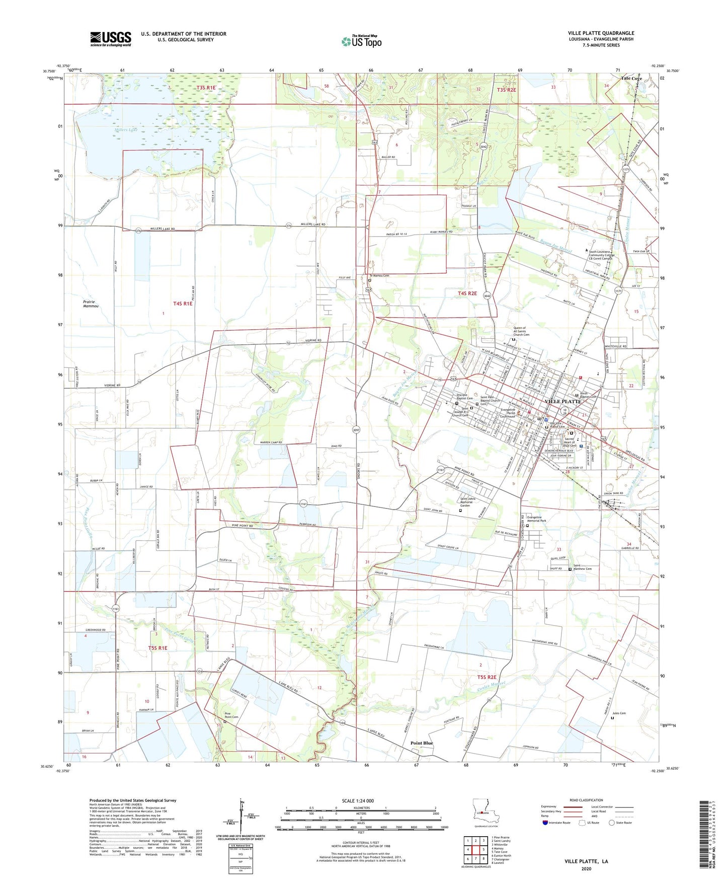
2024 topographic map quadrangle Ville Platte in the state of Louisiana. Scale: 1:24000. Based on the newly updated USGS 7.5' US Topo map series, this map is in the following counties: Evangeline. The map contains contour data, water features, and other items you are used to seeing on USGS maps, but also has updated roads and other features. This is the next generation of topographic maps. Printed on high-quality waterproof paper with UV fade-resistant inks.
Quads adjacent to this one:
West: Mamou
Northwest: Pine Prairie
North: Saint Landry
Northeast: Whiteville
East: Tate Cove
Southeast: Lawtell
South: Chataignier
Southwest: Eunice North
This map covers the same area as the classic USGS quad with code o30092f3.
Contains the following named places: Agape Christian Fellowship Church, Angie's Lil' Folks Day Care and Pre - Education Center, Antioch Baptist Church, Bayou Joe Marcel, Beech Street Head Start Center School, Christ Cathedral of Praise, City of Ville Platte, Coulee de Manuel, Country Day Care and Learning Center, Disciples Baptist Church, Evangeline Memorial Park, Evangeline Parish Agricultural Youth Facility, Evangeline Parish Courthouse, Evangeline Parish Health Unit, Evangeline Parish Library, Evangeline Parish Office, Evangeline Parish Police Jury, Evangeline Parish Sheriff's Office, First Baptist Church, Greater Mount Pleasant Baptist Church, Henry J Vidrine Memorial Park, Highland Shopping Center, Humana Hospital Ville Platte, Humana Hospital Ville Platte Heliport, James Stephens Montessori School, Jules Cemetery, KVPI-AM (Ville Platte), KVPI-FM (Ville Platte), Lelia Post Office, Maison De Sante Nursing Home, Maison Jean - Marie Laran Museum, Mercy Regional Medical Center, Millers Lake, Millers Lake Dam, Mount Pilgrim Baptist Church, New Life Assembly of God Church, Ninth Baptist Church, Northside Community Center, Parish Governing Authority District 11, Parish Governing Authority District 12, Parish Governing Authority District 13, Parish Governing Authority District 7, Parish Governing Authority District 8, Parkview Plaza Church of Christ, Parkview Shopping Center, Pine Point Cemetery, Platte Wastewater Treatment Facility, Point Blue, Point Blue Gas Field, Prairie Mammou, Queen of All Saints Church, Refuge Temple Church, Sacred Heart Catholic Church, Sacred Heart Elementary School, Sacred Heart High School, Saint John the Baptist Church, Saint Johns Memorial Garden, Saint Joseph Catholic Church, Saint Matthew Church, Saint Paul Baptist Church, Saint Peter Church, South Louisiana Community College CB Coreil Campus, Southside City Park, Stephens High School, Sylvesters Airport, Te Mamou Cemetery, Ville Platte, Ville Platte Church of Christ, Ville Platte City Hall, Ville Platte Elementary School, Ville Platte Fire Department, Ville Platte High School, Ville Platte Mental Health Clinic, Ville Platte Police Department, Ville Platte Post Office, Ville Platte Volunteer Fire Department District 2, Ward One, Ward One Industrial Park, ZIP Code: 70586