MyTopo
Watson Louisiana US Topo Map
Couldn't load pickup availability
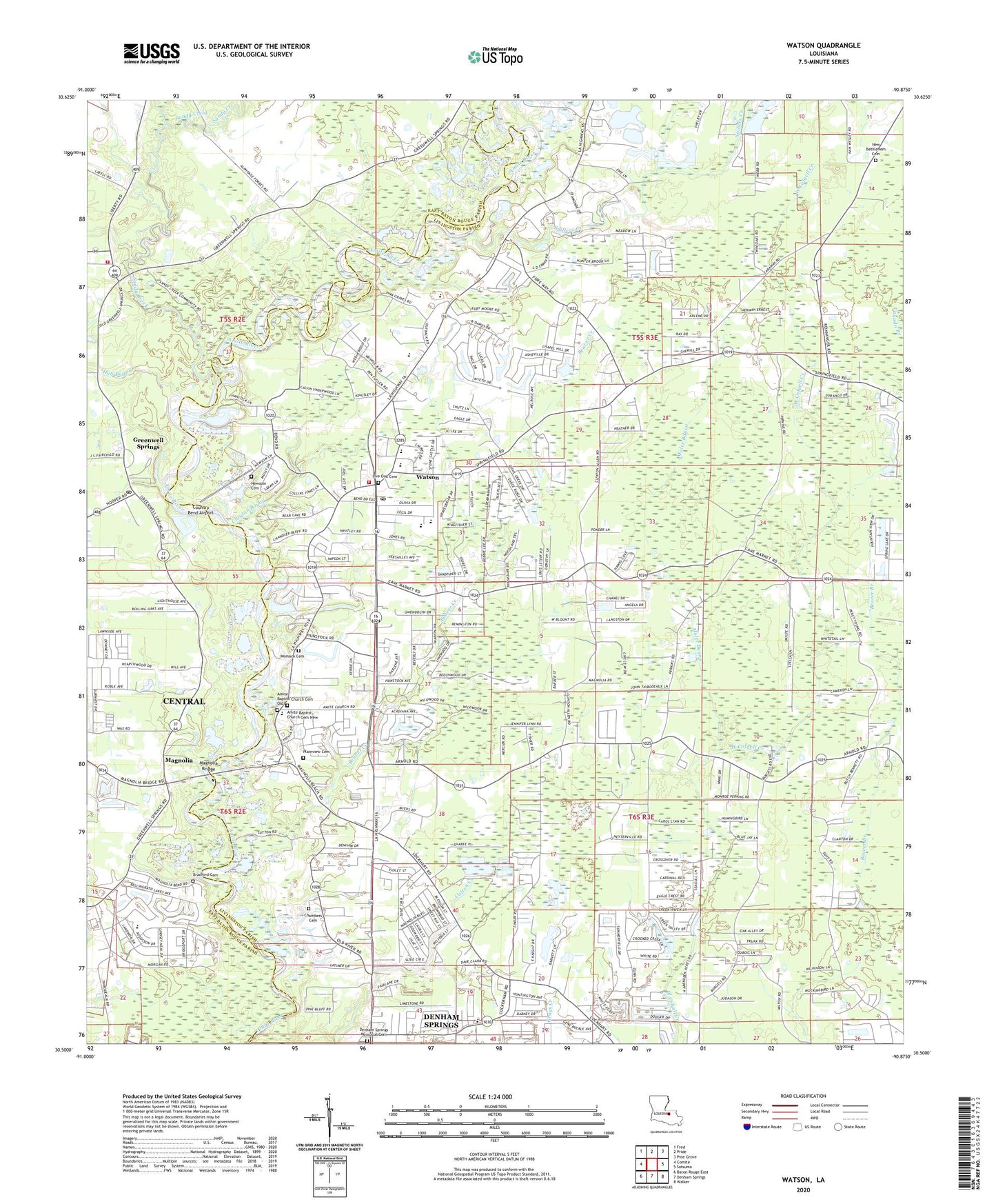
2024 topographic map quadrangle Watson in the state of Louisiana. Scale: 1:24000. Based on the newly updated USGS 7.5' US Topo map series, this map is in the following counties: Livingston, East Baton Rouge. The map contains contour data, water features, and other items you are used to seeing on USGS maps, but also has updated roads and other features. This is the next generation of topographic maps. Printed on high-quality waterproof paper with UV fade-resistant inks.
Quads adjacent to this one:
West: Comite
Northwest: Fred
North: Pride
Northeast: Pine Grove
East: Satsuma
Southeast: Walker
South: Denham Springs
Southwest: Baton Rouge East
This map covers the same area as the classic USGS quad with code o30090e8.
Contains the following named places: Amite Baptist Church, Amite Baptist Church Cemetery New, Amite Christian School, Beaver Creek, Bellingrath, Bellingrath Hills, Bellingrath Hills Elementary School, Berean Ministries, Bethel United Methodist Church, Bradford Cemetery, Burlington, Calvary Baptist Church, Camp Istrouma, Camp Ruth Lee, Canada Branch, Chambers Cemetery, Church of God of Prophecy, Clayton Bayou, Country Bend Airport, Covenant Community Church, Danni Lane Mobile Home Park, Denham Springs Memorial Cemetery, East Louisiana State Hospital Greenwell Springs, Eastern Louisiana Mental Health System Special School District, Emmanuel Baptist Church, Evergreen Hills, Flint Field, Freshwater Elementary School, Grace Community Bible Church, Greater Saint Peter Church, Greenwell Springs, Greenwell Springs Baptist Church, Greenwell Springs Hospital, Greenwell Springs Post Office, Greys Mobile Home Park, Harvest Manor Nursing Home, Hub Bayou, Indian Mound, Indian Mound Baptist Church, Jesus Christ Church Assembly, Lighthouse Church, Linder Mobile Home Park, Little Sandy Creek, Live Oak Elementary School, Live Oak High School, Live Oak Middle School, Live Oak Temple, Live Oak United Methodist Cemetery, Live Oak United Methodist Church, Livingston Parish Fire Protection District 4 Station 3, Livingston Parish Library Watson Branch, Lockhart Road Baptist Church, Magnolia, Magnolia Bend, Magnolia Bridge, Moler Bayou, Mount Olive Baptist Church, New Bethlehem Baptist Church, New Bethlehem Cemetery, Newsom Cemetery, North Live Oak Elementary School, Northside Baptist Church, Northwoods, Ochsner Health Center Denham Springs, Old Amite Baptist Church, Parish Governing Authority District 2, Parish Governing Authority District 3, Parish Governing Authority District 7, Plainview, Plainview Cemetery, Pride Volunteer Fire Department Station 11, Sandy Creek, Seven Oaks Baptist Church, South Live Oak Elementary School, Spillers Creek, Tiffany Estates Mobile Home Park, Watson, Watson Census Designated Place, Watson Church, Watson Estates Mobile Home Park, Watson Oil Field, Watson Post Office, WBIU-AM (Denham Springs), Womack Cemetery, ZIP Codes: 70706, 70739