MyTopo
Presque Isle Maine US Topo Map
Couldn't load pickup availability
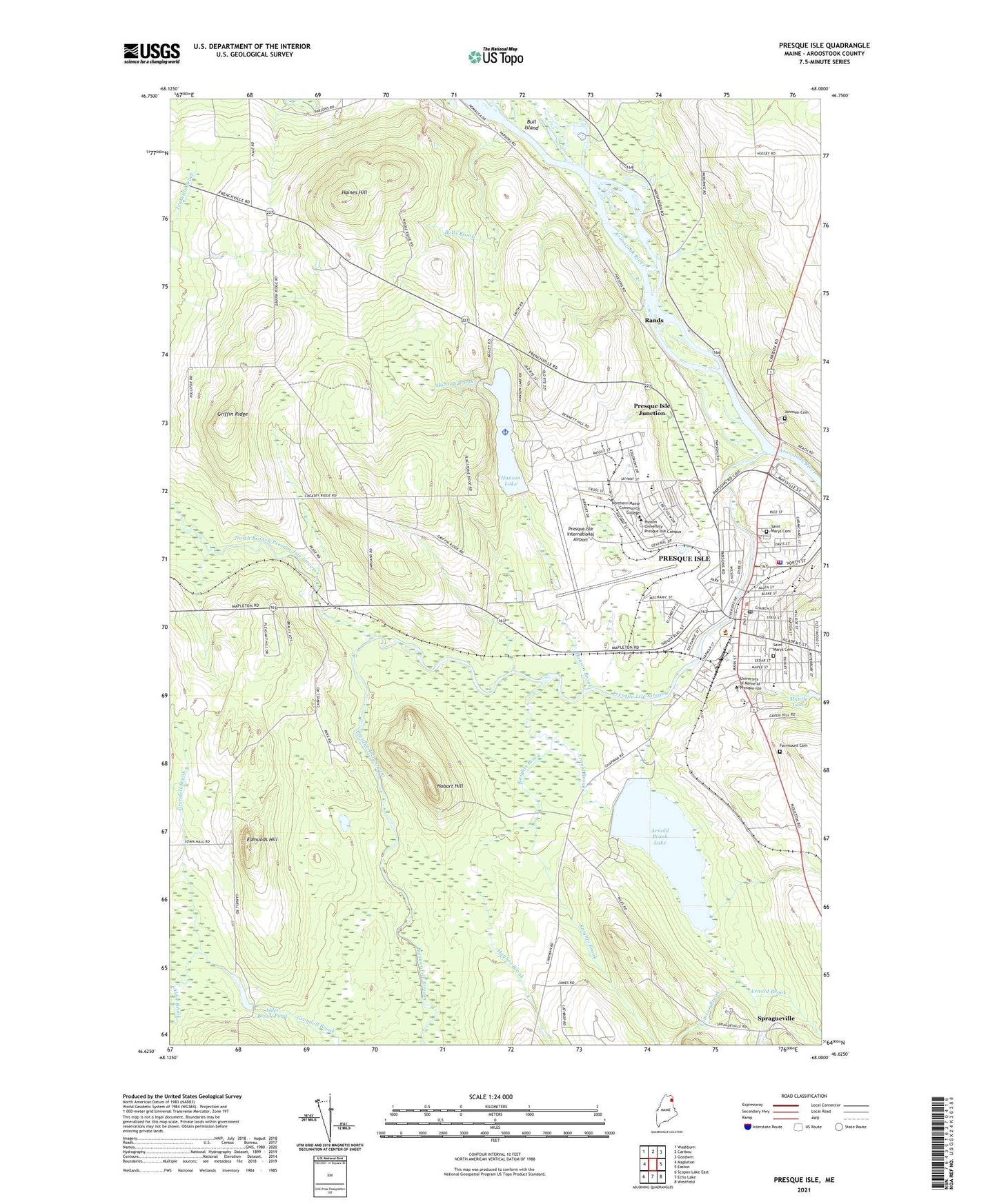
2024 topographic map quadrangle Presque Isle in the state of Maine. Scale: 1:24000. Based on the newly updated USGS 7.5' US Topo map series, this map is in the following counties: Aroostook. The map contains contour data, water features, and other items you are used to seeing on USGS maps, but also has updated roads and other features. This is the next generation of topographic maps. Printed on high-quality waterproof paper with UV fade-resistant inks.
Quads adjacent to this one:
West: Mapleton
Northwest: Washburn
North: Caribou
Northeast: Goodwin
East: Easton
Southeast: Westfield
South: Echo Lake
Southwest: Scopan Lake East
This map covers the same area as the classic USGS quad with code o46068f1.
Contains the following named places: Alder Brook, Alder Brook Dam, Alder Brook Pond, Arnold Brook, Arnold Brook Dam, Arnold Brook Lake, Arnold Brook Lake Recreation Area, Aroostook Centre Mall, Aroostook County Historical Center, Beacon Number 1, Bethany Baptist Church, Bicentennial Park, Bull Island, Bulls Brook, Caribou Road, Carleton Project Alternative High School, Christ Gospel Pentecostal Church, City of Presque Isle Recycling Center, Crouse Island, Cunningham Middle School, Echo Lake Dam, Edmunds Hill, Fairmount Cemetery, First United Pentecostal Church, Full Gospel Assembly Church, Gouldville Elementary School, Grant Memorial United Methodist Church, Griffin Ridge, Haines Hill, Hanson Brook, Hanson Lake, Hanson Lake Dam, Hobart Hill, Hodgedon School, Hughes Brook, James Schoolhouse, Johnson Cemetery, Julian W Turner Courthouse, Knights Brook, Lamson Brook, Loring Family Housing Annex, Maine School Administrative Alternative District 1 Education, Mantle Lake, Mantle Lake Dam, Mantle Lake Park, Maranatha Academy, Mark and Emily Turner Memorial Library, New Life Church, North Branch Presque Isle Stream, North Plaza Shopping Center, Northern Maine Community College, Northern Maine Community College Library, Northern Maine Fairgrounds, Northern Maine Forum, Northern Maine Regional Seaplane Base, Opportunity Training Center School, Park Siding, Peace Park, Pettingill Brook, Pine Street Elementary School, Presque Isle, Presque Isle Area Chamber of Commerce, Presque Isle Army Air Field, Presque Isle City Hall, Presque Isle Congregational Church, Presque Isle Dam, Presque Isle Fire Department, Presque Isle High School, Presque Isle Indoor Pool, Presque Isle International Airport, Presque Isle Junction, Presque Isle Middle School, Presque Isle Police Department, Presque Isle Post Office, Presque Isle Regional Career & Techical Center, Presque Isle Regional Career and Technical Center School, Presque Isle Shopping Center, Presque Isle Stream, Rands, Saint Johns Episcopal Church, Saint Marys Catholic Church, Saint Marys Cemetery, Seventh Day Adventist Church, Skyway Education Learning Center, Skyway Industrial Park, Skyway Middle School, Spragueville, State Road Church, State Street Baptist Church, Town of Mapleton, University of Maine at Presque Isle, University of Maine Presque Isle Library, Veterans Memorial Park, WAGM-TV (Presque Isle), WEGP-AM (Presque Isle), William Haskell Recreation Center, WKZX-AM (Presque Isle), WUPI-FM (Presque Isle), Zippel Elementary School