MyTopo
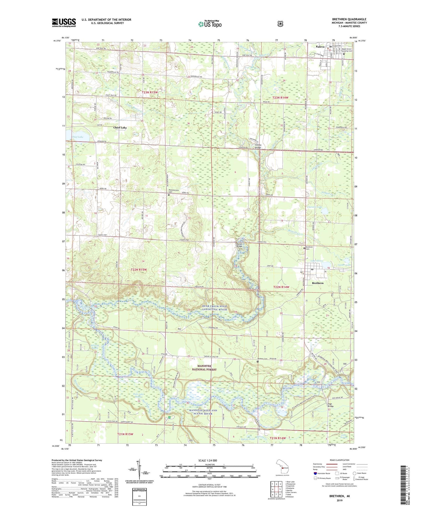
Brethren Michigan US Topo Map
Couldn't load pickup availability
Also explore the Brethren Forest Service Topo of this same quad for updated USFS data
2023 topographic map quadrangle Brethren in the state of Michigan. Scale: 1:24000. Based on the newly updated USGS 7.5' US Topo map series, this map is in the following counties: Manistee. The map contains contour data, water features, and other items you are used to seeing on USGS maps, but also has updated roads and other features. This is the next generation of topographic maps. Printed on high-quality waterproof paper with UV fade-resistant inks.
Quads adjacent to this one:
West: Onekama
Northwest: Bear Lake
North: Pleasanton
Northeast: Copemish
East: Marilla
Southeast: Wellston
South: Udell
Southwest: Star Corners
This map covers the same area as the classic USGS quad with code o44086c1.
Contains the following named places: Battle House Historical Marker, Bear Creek, Bear Creek Public Access, Bear Creek Wild and Scenic River, Beaver Creek, Bethany Lutheran Church, Blacksmith Bayou, Blacksmith Bayou Campground, Blacksmith Bayou Public Access, Boswell Creek, Brethren, Brethren Cemetery, Brethren Census Designated Place, Brethren High School, Brethren Post Office, Brethren Station, Browns Bayou, Browntown School, Cedar Creek, Center Lake, Chicken Creek, Chief Lake, Chief Lake Station, Christy Bridge, Church of the Brethren, Clarence Lake, Deer Lake Bayou, Dickson Cemetery, Dickson Township Fire Department, Dickson Township Hall, Dickson Township Park, Epworth United Methodist Church, High Bridge, High Bridge Post Office, High Bridge Public Access, Horseshoe Creek, Kaleva, Kaleva and Wellston Medical Center, Kaleva Baptist Church, Kaleva Depot Museum, Kaleva Historical Marker, Kaleva Post Office, Kaleva Roadside Park, Kaleva Station, Kaleva-Norman-Dickson School, Lake Elinor, Little Beaver Creek, Manikawa Park, Manikiwa Recreation Site, Manistee Wild and Scenic River, Maple Grove Township Cemetery, Old High Bridge R R Crossing Site, Pine Creek, Pleasant View Cemetery, Pleasantview Church, Podunk Creek, Potter Bridge, Sergant Bayou, Sylvan Creek, Sylvan Pond, Tanner Post Office, Tanner Station, Tannerville, Township of Brown, Udell Rollways Recreation Area, Village of Kaleva, Williamson Creek, ZIP Code: 49645