MyTopo
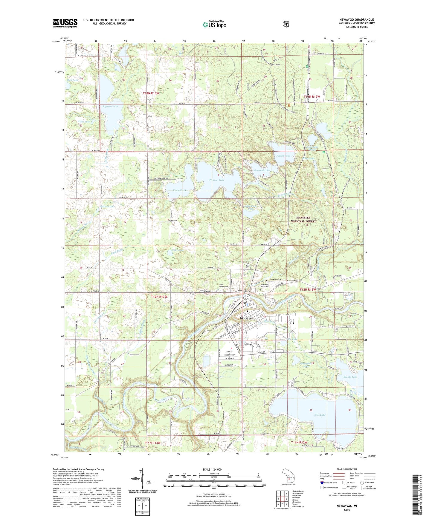
Newaygo Michigan US Topo Map
Couldn't load pickup availability
Also explore the Newaygo Forest Service Topo of this same quad for updated USFS data
2023 topographic map quadrangle Newaygo in the state of Michigan. Scale: 1:24000. Based on the newly updated USGS 7.5' US Topo map series, this map is in the following counties: Newaygo. The map contains contour data, water features, and other items you are used to seeing on USGS maps, but also has updated roads and other features. This is the next generation of topographic maps. Printed on high-quality waterproof paper with UV fade-resistant inks.
Quads adjacent to this one:
West: Fremont
Northwest: Dayton Center
North: White Cloud
Northeast: Big Prairie
East: Croton
Southeast: Sand Lake SW
South: Grant
Southwest: Bridgeton
This map covers the same area as the classic USGS quad with code o43085d7.
Contains the following named places: Abeys Lake, Ackland Lake, Anderson Flats Public Access, Believers Bible Chapel, Bigelow Creek, Bigelow School, Body of Christ Lutheran Church, Briar Hill Golf Course, Brookhaven Estates Mobile Home Park, Brooks Creek, Brooks Lake, Brooks Lake Chapel, Butterfield Lake, Camp Echo, Christenson Drain, City of Newaygo, Continu-Care-Gerber Memorial Hospital, Cope Lake, Drew Siding, EH Henning County Park, Emerald Lake, Faith Temple, First Baptist Church, Fourmile Creek, Garfield Center School, Grace Bible Church, Greenwood Creek, Henry Camp, Hess Lake, John Ford Lake, June Lake, Kemperman Lake, Kimball Lake, Kimball Lake School, Lake Forest Mobile Home Park, Little Lake, Little Lake Placid, Living Hope Lutheran Fellowship, Ludke Drain, Moses Drain, Mystery Creek Campground, New Community Church of Newaygo, Newaygo, Newaygo Airport, Newaygo Carnegie Library, Newaygo City Cemetery, Newaygo County Historical Museum, Newaygo County Sports Park, Newaygo Fire Department, Newaygo High School, Newaygo Lakes Lookout Tower, Newaygo Middle School, Newaygo Police Department, Newaygo Post Office, Newaygo Station, Newaygo United Methodist Church, Penoyer Creek, Pickerel Lake, Pine Medical Group, Resurrection Life Church, River Valley Community Church, Ryerson Lake, Saint Bartholomew Church, Saint Marks Cemetery, Saint Mark's Episcopal Church, Salmon Run Campground, Shaw Park, Sylvan Lake, Township of Garfield, Twinwood Lake, United Church of Christ, Velma Matson Upper Elementary School, Vera Wilsie School, Victory Fellowship Church, Village Green Golf Club, Wierenga's Hess Lake Mobile Home Park, Zeigler Roadside Park