MyTopo
Fremont Michigan US Topo Map
Couldn't load pickup availability
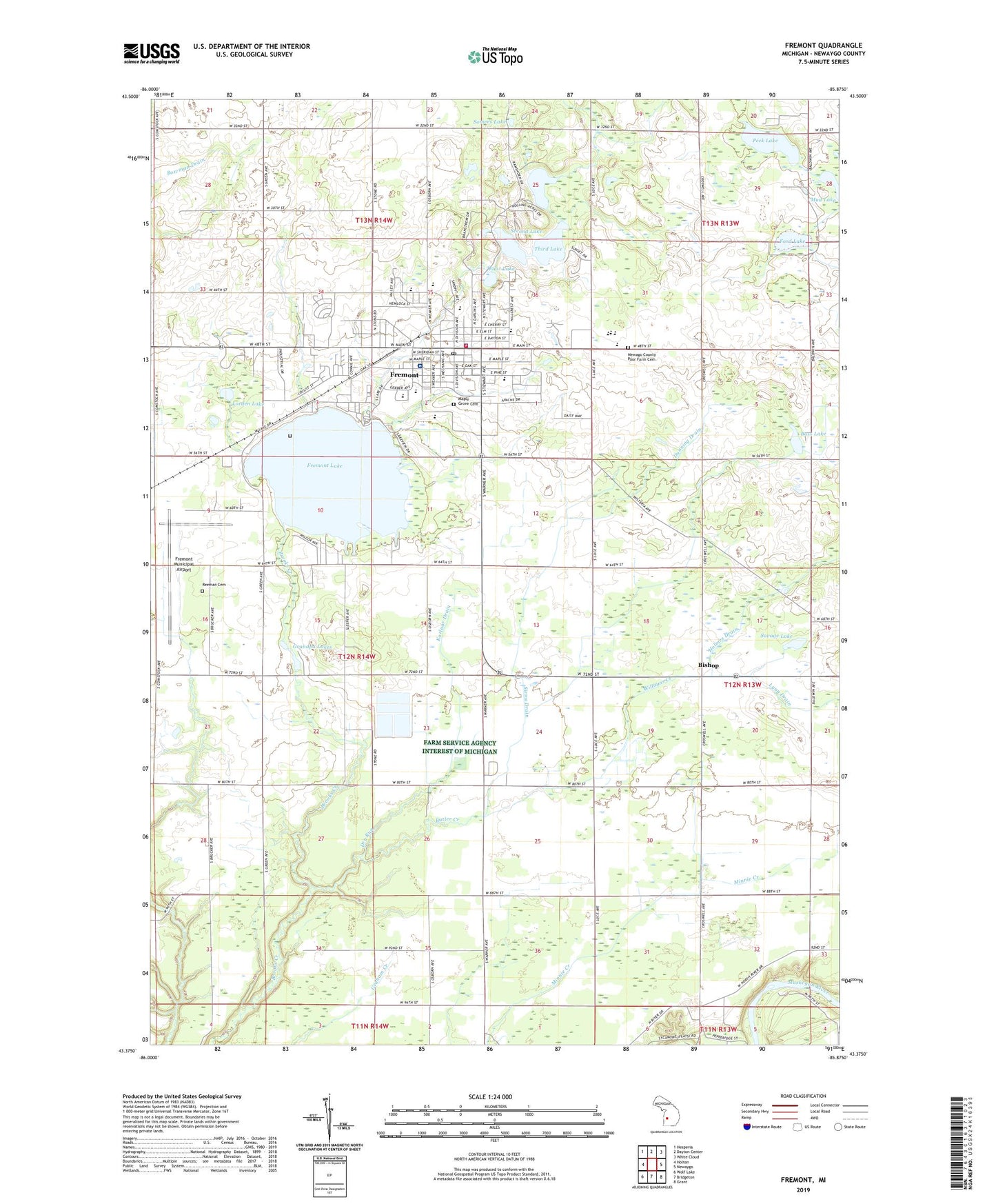
2023 topographic map quadrangle Fremont in the state of Michigan. Scale: 1:24000. Based on the newly updated USGS 7.5' US Topo map series, this map is in the following counties: Newaygo. The map contains contour data, water features, and other items you are used to seeing on USGS maps, but also has updated roads and other features. This is the next generation of topographic maps. Printed on high-quality waterproof paper with UV fade-resistant inks.
Quads adjacent to this one:
West: Holton
Northwest: Hesperia
North: Dayton Center
Northeast: White Cloud
East: Newaygo
Southeast: Grant
South: Bridgeton
Southwest: Wolf Lake
This map covers the same area as the classic USGS quad with code o43085d8.
Contains the following named places: All Saints Catholic Church, All Saints Mount Calvary Cemetery, Arboretum Park, Assembly of God Church, Bass Lake, Bishop, Bishop Post Office, Brookside, Brookside Post Office, Brookside School, Butler Creek, Butler School, Carlson Drain, Cedar Street School, Charter Township of Sheridan, Christian Junior High School, Christian Life Fellowship, Church of Jesus Christ of Latter Day Saints, Church of the Living Christ, City of Fremont, Country View Estates Mobile Home Park, Dry Run, Dunning Drain, Dusty Brooks School, Faith Baptist Church, Faith Christian School, First Baptist Church, First Christian Reformed Church, First Congregational Church, First Lake, First Reformed Church, Ford Lake, Fourth Lake, Fremont, Fremont Area District Library, Fremont Christian Church, Fremont Church of Christ, Fremont Church of the Nazarene, Fremont City Hall, Fremont Fire Department, Fremont High School, Fremont Lake, Fremont Lake Park, Fremont Middle School, Fremont Municipal Airport, Fremont Police Department, Fremont Post Office, Fremont Station, Fremont United Methodist Church, Fremont Wesleyan Church, Grace Community Church, Grandpa Lakes, Hill's Mobile Home Park, Holmes Drain, Kempf Lake, Kingdom Hall of Jehovah's Witnesses, Korlaar Drain, Lake Park Campground, Life Emergency Medical Services of Newaygo County, Lorden Lake, Lorden School, Lynn Drain, Main Street Internal Medicine Clinic, Maple Grove Cemetery, Meadowview Village Mobile Home Park, Mud Lake, Newago County Poor Farm Cemetery, Newaygo County Baptist Academy, Newaygo County Fairgrounds, Newaygo County Vocational School, Newaygo Medical Care Facility, Packard School, Pathfinder Elementary School, Peck Lake, Pine Medical Group, Pine Street School, Providence Christian High School, Ramshorn on the Lakes Golf Course, Redeemer Lutheran Church, Reeman Cemetery, Root Town School, Saint John's Episcopal Church, Savage Lake, Schenck School, Second Christian Reformed Church, Second Lake, Seventh Day Adventist Church, Sheridan Park, Siems Drain, Somers Lake, South Garfield School, Spectrum Health Gerber Memorial Hospital, Summer Breeze Par Three Golf Course, Third Lake, Trinity Christian Reformed Church, Van Korlaar School, Veterans Memorial Park, Waters School, Williams Creek, WJ Branstrom Park, WSHN-AM (Fremont), WSHN-FM (Fremont), ZIP Code: 49412