MyTopo
Clarksdale Mississippi US Topo Map
Couldn't load pickup availability
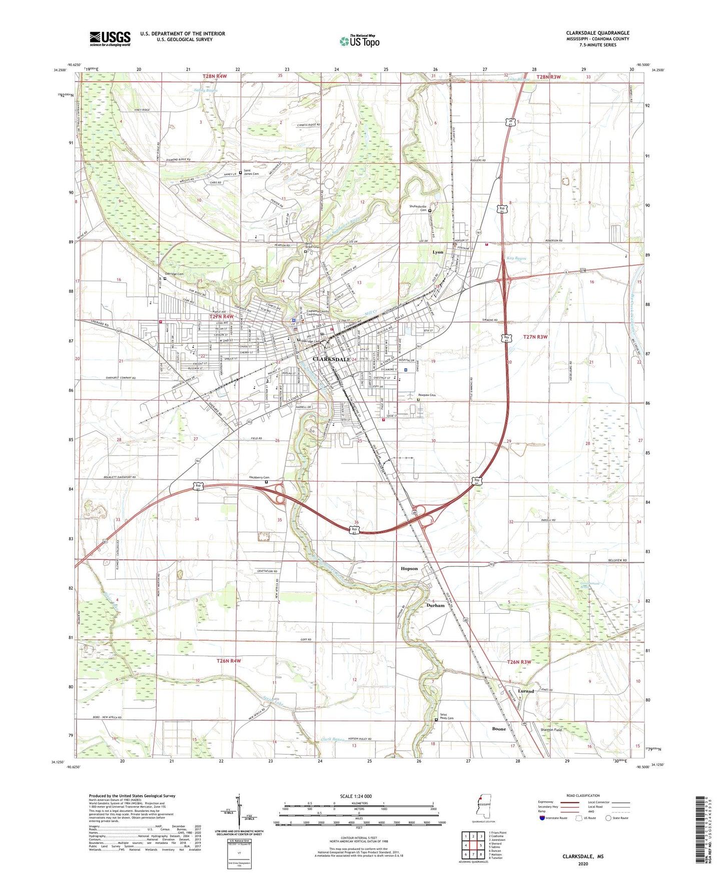
2024 topographic map quadrangle Clarksdale in the state of Mississippi. Scale: 1:24000. Based on the newly updated USGS 7.5' US Topo map series, this map is in the following counties: Coahoma. The map contains contour data, water features, and other items you are used to seeing on USGS maps, but also has updated roads and other features. This is the next generation of topographic maps. Printed on high-quality waterproof paper with UV fade-resistant inks.
Quads adjacent to this one:
West: Sherard
Northwest: Friars Point
North: Coahoma
Northeast: Jonestown
East: Sabino
Southeast: Tutwiler
South: Mattson
Southwest: Duncan
This map covers the same area as the classic USGS quad with code o34090b5.
Contains the following named places: Anderson Park, Anderson Shopping Plaza Shopping Center, Beasley Lake, Bell Grove Baptist Church, Beth Israel Cemetery, Booker T Washington School, Boone, Calvary Baptist Temple, Carnegie Library, Cedar Mound Plantation, Centennial Baptist Church, Chapel Hill Baptist Church, Cherry Street Baptist Church, Church of Christ, Church of the Lord Jesus Christ of the Apostolic Faith, Church of the Nazarene, City of Clarksdale, Clark School, Clarksdale, Clarksdale Baptist Church, Clarksdale City Hall, Clarksdale Country Club, Clarksdale Fire Department Central Station, Clarksdale Fire Department Station 3, Clarksdale Fire Department Station 4, Clarksdale High School, Clarksdale Junior High School, Clarksdale Police Department, Clarksdale Post Office, Clarksdale Seventh Day Adventist Church, Clarksdale Shopping Center, Coahoma County, Coahoma County Courthouse, Coahoma County Sheriff's Office, Coahoma County Volunteer Fire Department Main Station, Coahoma High School, Commerce Plaza Shopping Center, Cunningham Church of God in Christ, Cypress Lake, Damascus Baptist Church, Delta Blues Museum, Delta Health - Northwest Regional Hospital, Desoto Shopping Center, Dixie Youth Park, Durham, First Baptist Church, First Christian Church, First Presbyterian Church, First United Methodist Church, Friendship African Methodist Episcopal Church, Government Brake, Greater First Apostolic Temple, Hackberry Cemetery, Hall Elementary School, Harold Simmons Lake Dam, Harrs Place, Haven United Methodist Church, Heidelberg Elementary School, Higgins High School, Honey Hill Plantation, Hopson, Hopson Bayou, Hopson Church, Immaculate Conception Catholic Church, Immaculate Conception School, Jerusalem Baptist Church, Kay Bayou, Kings Temple Missionary Baptist Church, Kirkpatrick Elementary School, Lake Bayou, Liberty Baptist Church, Little Sunflower River, Lurand, Lyon, Lyon Baptist Church, Lyon Post Office, Lyon School, Lyon United Methodist Church, Mercy Seat Church, Mill Creek, Morning Star Church, Mount Carmel Church, Myrtle Hall, New Bethel Baptist Church, New Centennial Missionary Baptist Church, New Hope Baptist Church, New Hope Church, New Morning Star Baptist Church, Oakhurst Baptist Church, Oakhurst Elementary School, Oakhurst Village Shopping Center, Oakridge Cemetery, Oliver Elementary School, Pawpaw Cemetery, Pilgrims Rest Church, Rayford Chapel Baptist Church, Riverton, Riverton Elementary School, Riverton Junior High School, Saint Elizabeth Catholic Church, Saint Elizabeth School, Saint Georges Episcopal Church, Saint Georges School, Saint James Cemetery, Saint James Temple Church of God in Christ, Saint Pauls Cemetery, Saint Pauls Church, Saint Pauls United Methodist Church, Sandy Bayou, Sevier Lake, Shannon Field, Shufordsville Cemetery, Shutersville, Silent Grove Baptist Church, Town of Lyon, Union Grove Baptist Church, Washington Elementary School, Westgate Shopping Center, White Stone Church, WJBI-FM (Clarksdale), WROX-AM (Clarksdale), ZIP Code: 38614