MyTopo
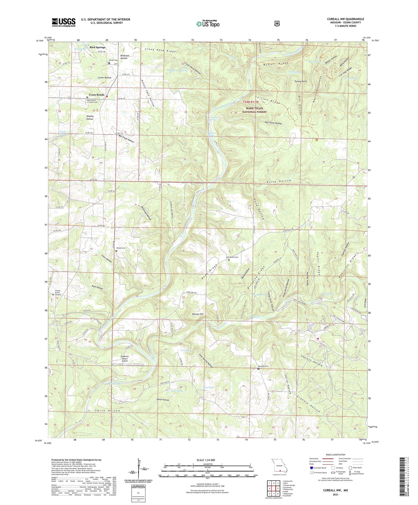
Cureall NW Missouri US Topo Map
Couldn't load pickup availability
Also explore the Cureall NW Forest Service Topo of this same quad for updated USFS data
2021 topographic map quadrangle Cureall NW in the state of Missouri. Scale: 1:24000. Based on the newly updated USGS 7.5' US Topo map series, this map is in the following counties: Ozark. The map contains contour data, water features, and other items you are used to seeing on USGS maps, but also has updated roads and other features. This is the next generation of topographic maps. Printed on high-quality waterproof paper with UV fade-resistant inks.
Quads adjacent to this one:
West: Sycamore
Northwest: Gentryville
North: Dora
Northeast: Siloam Springs
East: Pottersville
Southeast: Caulfield
South: Bakersfield
Southwest: Udall
This map covers the same area as the classic USGS quad with code o36092f2.
Contains the following named places: Althea, Althea Spring, Amber Spring, Arnold Branch, Ball Church, Ball Pond Hollow, Ball School, Bill Hollow, Bird Springs, Blair Bridge Park, Bond Hollow, Bond Ridge, Bond Ridge Church, Carrol Hollow, Cave Spring, Cave Spring Hollow, Clapp Spring, Click Hollow, Cloud 9 Ranch Fire Department, Collins Ridge, Collins School, Collins Spring, Colvin School, Creek Pond Hollow, Creek Pond Ridge, Crooked Branch, Cross Roads, Devils Backbone Wilderness, Devils Blackbone, Dividing Ridge, Dora Volunteer Fire Department, Dormis, Duncan Ford, Duncan Hill, Fogey Cave Hollow, Fogey Spring, Forest Grove School, Frazier Burial Ground, Grannis Hollow, Graveyard Hollow, Hall Pond Hollow, High Place Lookout Tower, James Branch, Kelly Hollow, Lane Spring, Lone Pilgrim School, Low Gap Ridge, Marshall Cemetery, Mary Hollow, McGarr Hollow, McGarr Ridge, McGarr Spring, Moss Spring, Mount Olive School, New Liberty Church, North Fork Springs, Oak Mound, Oak Mound Cemetery, Oak Mound School, Odom Church, Parson Cemetery, Piney Point Hollow, Pond Hollow, Portwood Hollow, Potato Cave Hollow, Raccoon Hollow, Rainbow Spring, Robinson Ridge, Ruth Hollow, Sawmill Hollow, Sheriff Hollow, Shipley Spring, Smith Hollow, Spoon Hollow, Spoon Spring, Spring Creek, Sunburst Ranch Airport, Taylor Hollow, Taylor Ridge, The Falls, Township of Richland, Township of Spring Creek, Turkey Point, Valley Star School, Wilder Spring, Woods Cemetery