MyTopo
Farmington Missouri US Topo Map
Couldn't load pickup availability
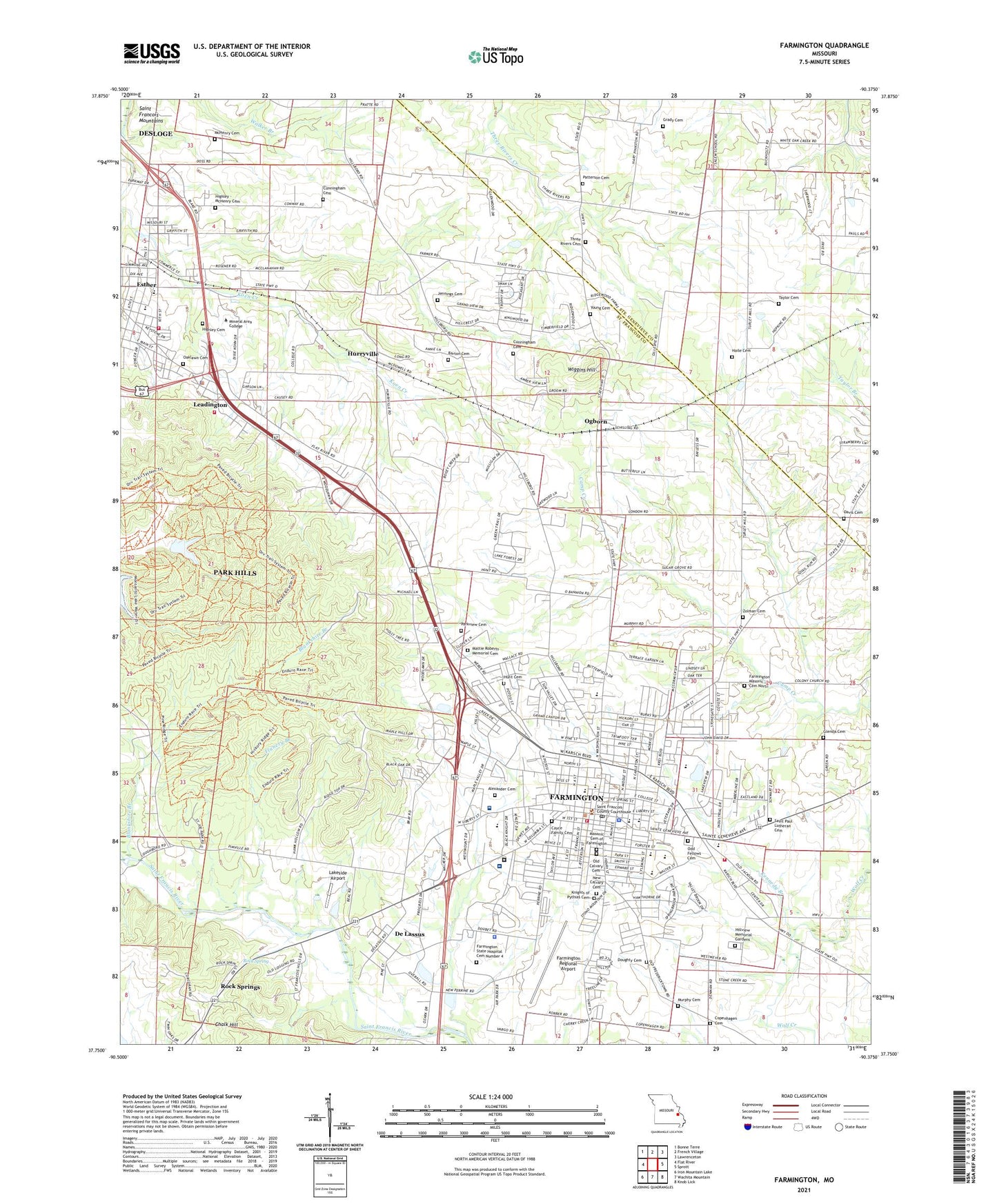
2023 topographic map quadrangle Farmington in the state of Missouri. Scale: 1:24000. Based on the newly updated USGS 7.5' US Topo map series, this map is in the following counties: St. Francois, Ste. Genevieve. The map contains contour data, water features, and other items you are used to seeing on USGS maps, but also has updated roads and other features. This is the next generation of topographic maps. Printed on high-quality waterproof paper with UV fade-resistant inks.
Quads adjacent to this one:
West: Flat River
Northwest: Bonne Terre
North: French Village
Northeast: Lawrenceton
East: Sprott
Southeast: Knob Lick
South: Wachita Mountain
Southwest: Iron Mountain Lake
This map covers the same area as the classic USGS quad with code o37090g4.
Contains the following named places: Barton Cemetery, Barton School, Bible Chapel, Blankshire Branch, Chalk Hill, City of Farmington, City of Leadington, Columbia Park, Copenhagen, Copenhagen Cemetery, Copenhagen German Methodist Church, Copenhagen School, Cunningham Cemetery, Davis Cemetery, De Lassus, De Lassus School, Doughty Cemetery, Esther, Farmington, Farmington Community Hospital Heliport, Farmington Correctional Center, Farmington Fire Department, Farmington Masonic Cemetery North, Farmington Plaza, Farmington Police Department, Farmington Post Office, Farmington Regional Airport, Flanery Branch, Flanery School, Glenda Cemetery, Grady Cemetery, Hacienda Rest Home, Haile Cemetery, Highley - McHenry Cemetery, Highley Cemetery, Hillview Memorial Gardens, Holy Family Fathers Seminary, Hunt Cemetery, Hurryville, Jefferson School, Jennings Cemetery, Kennedy Branch, KREI-AM (Farmington), Lakeside Airport, Leadington, Leadington Fire Department, Leadington Police Department, Masonic Cemetery of Farmington, Mattie Roberts Memorial Cemetery, McHenry Cemetery, Mine Number 10, Mine Number 25, Mineral Area College Fire and Rescue Academy, Mineral Area Regional Medical Center, Missouri Department of Conservation Forestry Southeast Regional Field Fire Office Farmington, Murphy Cemetery, New Calvary Cemetery, Oak Grove Free Will Baptist Church, Oak Hill School, Oaklawn Cemetery, Ogborn, Old Calvary Cemetery, Ozark Hills Golf Club, Park Hills Fire Department Station 3, Parkland Health Medical Center - Farmington, Parkview Cemetery, Patterson Cemetery, Rock Spring, Rock Springs, Saint Francois Country Club, Saint Francois County, Saint Francois County Sheriff's Office, Saint Francois Plaza, Saint Josephs High School, Saint Paul Lutheran Cemetery, Saint Paul School, Saint Pauls Evangelical Lutheran Church, Southeast Missouri Mental Health Medical Center, State Hospital Quarry, Sugar Grove School, Tayler School, Taylor Cemetery, Three Rivers Baptist Church, Three Rivers Cemetery, Township of Saint Francois, W L Johns School, Washington School, Wiggins Hill, Wilson Rozier Park, Wolf Creek Fire Department, Young Cemetery, Zolman Cemetery, ZIP Code: 63640