MyTopo
Rolla Missouri US Topo Map
Couldn't load pickup availability
Also explore the Rolla Forest Service Topo of this same quad for updated USFS data
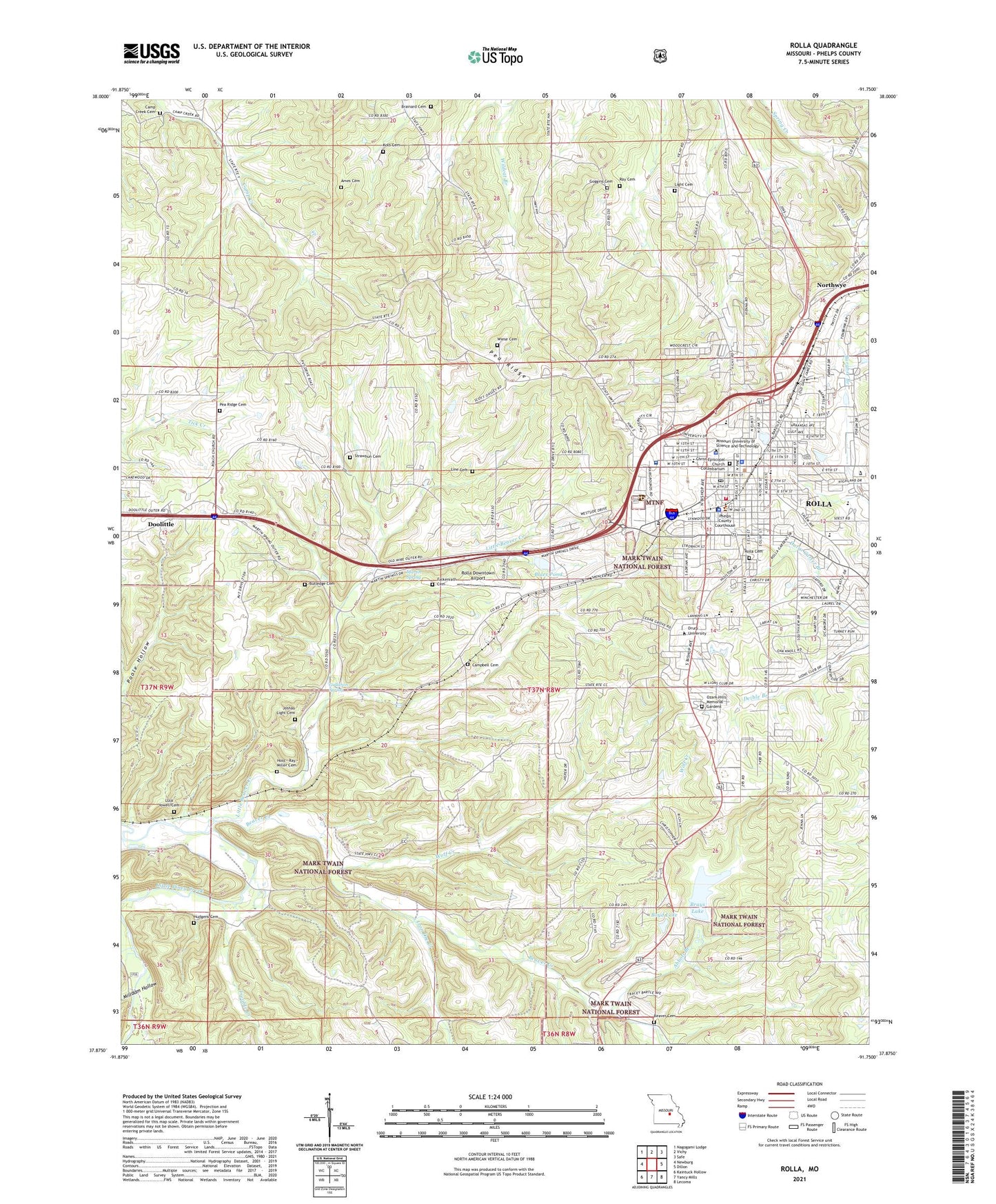
2021 topographic map quadrangle Rolla in the state of Missouri. Scale: 1:24000. Based on the newly updated USGS 7.5' US Topo map series, this map is in the following counties: Phelps. The map contains contour data, water features, and other items you are used to seeing on USGS maps, but also has updated roads and other features. This is the next generation of topographic maps. Printed on high-quality waterproof paper with UV fade-resistant inks.
Quads adjacent to this one:
West: Newburg
Northwest: Nagogami Lodge
North: Vichy
Northeast: Safe
East: Dillon
Southeast: Lecoma
South: Yancy Mills
Southwest: Kaintuck Hollow
This map covers the same area as the classic USGS quad with code o37091h7.
Contains the following named places: Abbott Branch, Ames Cemetery, B W Robinson State School, Barnitz Park, Beaver Cemetery, Beaver Church, Beaver Creek, Beaver Creek Mine, Benton School, Ber Juan Park, Blues Pond, Blues Pond Dam, Boyd Lake, Boyd Lake Dam, Brainard Cemetery, Brays Lake, Brays Lake Dam, Bridge School, Buckland Mine, Buehler Park, Burgher Branch, Butledge Cemetery, Camp Creek Cemetery, Camp Creek Church, Camp Creek School, Campbell Cemetery, Cerebral Palsy School, Christ Episcopal Church, Christ Episcopal Church Columbarium, Church of Christ, City of Rolla, Coolbrook Swimming Pool, Corinth School, Falkenrath Cemetery, Forbes Clay Pit, Frisco Lake, Goggins Cemetery, Gollahon Spring, Green Acres Park, Harry S Truman Elementary School, Hirsche School, Hoss - Ray - Miller Cemetery, Hudgens Cemetery, Hurricane Point, Immanuel School, Iron Ore Creek, Joshau Light Cemetery, KCLU-FM (Rolla), KMNR-FM (Rolla), KMOZ-AM (Rolla), Kolb Cemetery, Light Cemetery, Line Cemetery, Lions Park, Little Beaver Creek, Lula Yowell Cemetery, Mark Twain National Forest Interagency Office, Mark Twain National Forest Ranger District Rolla Office, Mark Twain School, Martin Spring, Middle School, Milldam Hollow, Missouri Department of Conservation Forestry Ozark Regional Field Fire Office Rolla, Missouri Department of Conservation Headquarters, Missouri School of Mines Mine, Missouri State Highway Patrol Troop I Headquarters, Missouri Trachoma Hospital, Missouri University of Science and Technology, Northwye, Oak Grove School, Ozark Hills Memorial Gardens, Pea Ridge, Pea Ridge Cemetery, Pershing School, Phelps County, Phelps County Sheriff's Office, Phelps Health Hospital, Point Bluff School, Ray Cemetery, Regional Fairground, Ridgeview Park, Roach Union Church, Rock Mechanics Center, Rolla, Rolla Cemetery, Rolla Downtown Airport, Rolla Fire and Rescue Department Station 2, Rolla Police Department, Rolla Post Office, Rolla Ranger Station, Rolla Technical Institute, Russell Brothers Circus, Saint Patrick School, Schuman Park, Strawhun Cemetery, Strawhun School, The Church of Jesus Christ of Latter Day Saints, Township of Rolla, Treable Creek, Wiese Cemetery, Wolf Creek, Wyman School, ZIP Code: 65401