MyTopo
Saint Joseph North Missouri US Topo Map
Couldn't load pickup availability
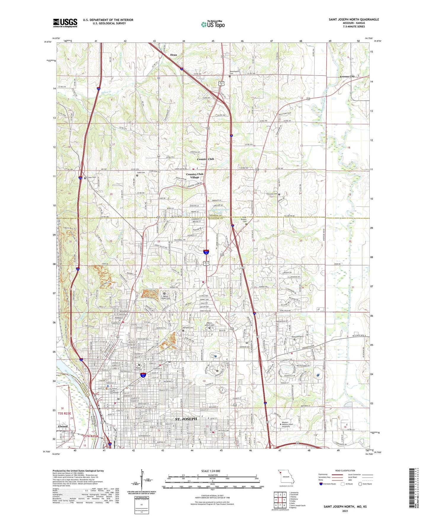
2021 topographic map quadrangle Saint Joseph North in the states of Missouri, Kansas. Scale: 1:24000. Based on the newly updated USGS 7.5' US Topo map series, this map is in the following counties: Buchanan, Andrew, Doniphan. The map contains contour data, water features, and other items you are used to seeing on USGS maps, but also has updated roads and other features. This is the next generation of topographic maps. Printed on high-quality waterproof paper with UV fade-resistant inks.
Quads adjacent to this one:
West: Wathena
Northwest: Amazonia
North: Savannah
Northeast: Helena
East: Cosby
Southeast: Agency
South: Saint Joseph South
Southwest: Halls
This map covers the same area as the classic USGS quad with code o39094g7.
Contains the following named places: Ashland Cemetery, Avenue City, Avenue City Elementary School, Bartlett Park, Beeler School, Bishop Le Blond High School, Blair School, Bliss Junior High School, B'nai Sholem Cemetery, Bode Middle School, Breckenridge School, Buchanan County Academy, Buchanan County Sheriff's Office, Building Bridges School, Camp Geiger, Castle School, Central High School, Charles A Lindbergh Elementary School, Christian Brothers High School, City of Saint Joseph, Colemen Elementary School, Country Club Village, County Boys Home, Crowley Creek, Dean, Eastside Post Office, Edison Elementary School, Elwood, Eugene Field Elementary School, Eureka School, Fairleigh Post Office, Fairview Church, Fairview Cumberland Presbyterian Cemetery, Faith Church, France Park, Green Acres Rest Home, Green Cemetery, Green Valley Church, Green Valley School, Hall Elementary School, Harry S Truman Middle School, Heartland Hospital West Heliport, Hebrew School, Hillyard School, Hillyard Technical Center, Horace Mann School, Humboldt Elementary School, Huston Wyeth Park, Immaculate Conception School, Jesse James Home, Jimtown Church, John Glenn Elementary School, John J Pershing Elementary School, Keller Lake, Keller Lake Dam, KFEQ-AM (St Joseph), KQTV-TV (St Joseph), Krug Park, Ladd Cemetery, Lafayette High School, Lakeland Estates Lake, Lakeland Estates Lake Dam, Lewis Park, Living Hope Church, Long Branch, Mark Twain Elementary School, Maxwell School, Miller School, Missouri Department of Conservation Forestry Northwest Regional Field Fire Office Saint Joseph, Missouri State Highway Patrol Troop H, Missouri Western State University Western Campus, Mitchell Park, Moila Golf Course, Mononame 278 Dam, Mosaic Life Care at Saint Joseph, Mount Auburn Cemetery, Mount Mora Cemetery, Mount Olivet Cemetery, Northwest Missouri Psychiatric Rehabilitation Center, Noyes Elementary School, Oak Grove Chapel, Oak Grove Church, Oak Grove School, Parkway Elementary School, Patee Home, Patee Park, Prescott Seventh Day Adventist School, River Bluffs Park, Riverbend Treatment Center, Riverview School, Robidoux Middle School, Roys Branch, Ruth Huston Learning Center, Saint Francis Xavier School, Saint Joseph, Saint Joseph Cathedral School, Saint Joseph Christian School, Saint Joseph Fire Department Station 1, Saint Joseph Fire Department Station 12, Saint Joseph Fire Department Station 4, Saint Joseph Fire Department Station 5, Saint Joseph Fire Department Station 8, Saint Joseph Fire Department Station 9, Saint Joseph Memorial Park, Saint Joseph Post Office, Saint Marys School, Saint Patricks Elementary School, Saint Paul Church, Saint Paul Lutheran School, Saint Peter Church, Savannah Rural Fire Protection, Sherwood School, Todd School, Township of Jefferson, Township of Washington, Vanschoiack Cemetery, Vatterott College, Village of Country Club, Washington School, Water Works, Webster Elementary School, Western Reception Diagnostic and Correctional Center, Woodbine Church, Woodbine School, Woodson's Children's Hospital School, ZIP Codes: 64501, 64505, 64506