MyTopo
Dillon West Montana US Topo Map
Couldn't load pickup availability
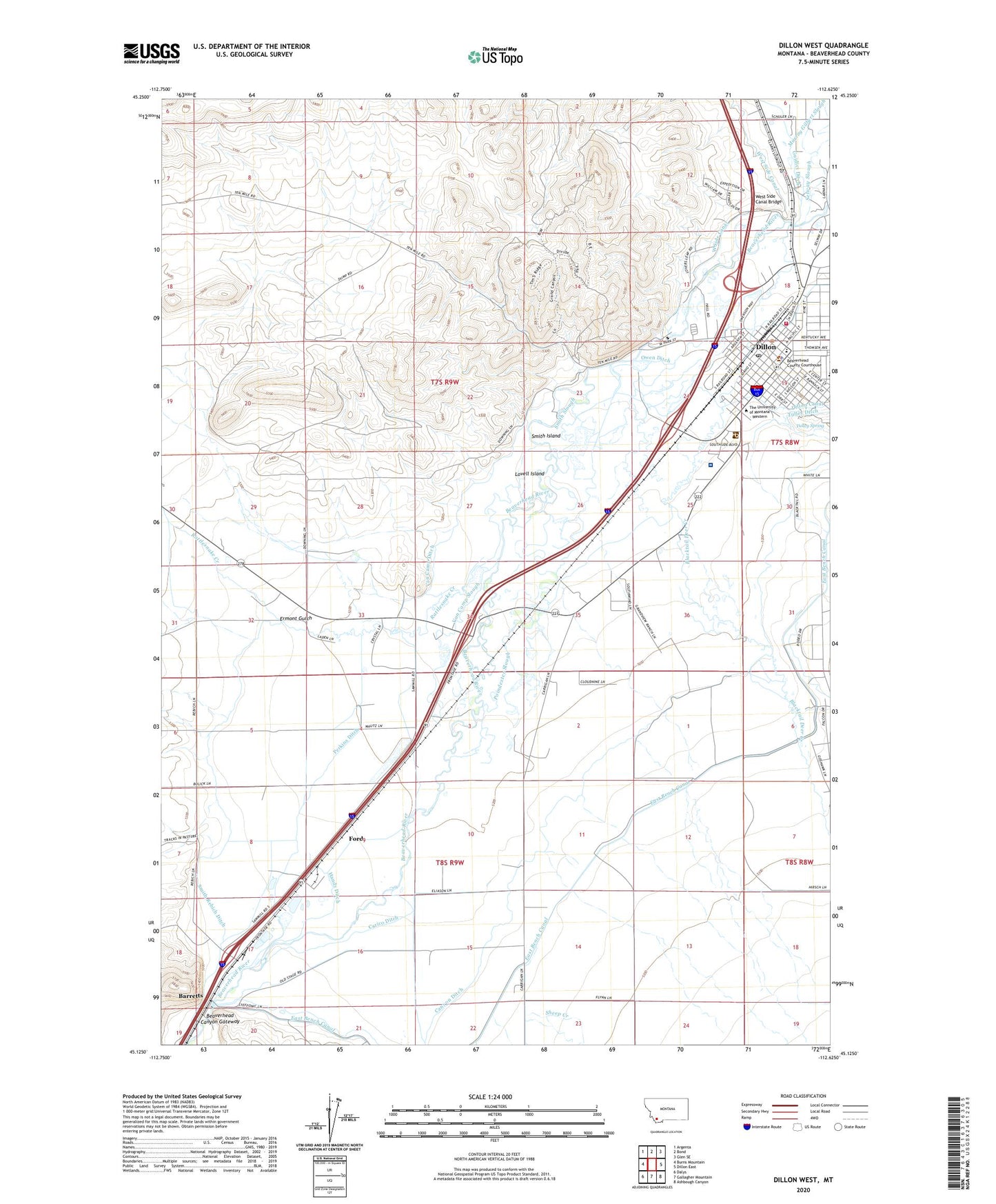
2024 topographic map quadrangle Dillon West in the state of Montana. Scale: 1:24000. Based on the newly updated USGS 7.5' US Topo map series, this map is in the following counties: Beaverhead. The map contains contour data, water features, and other items you are used to seeing on USGS maps, but also has updated roads and other features. This is the next generation of topographic maps. Printed on high-quality waterproof paper with UV fade-resistant inks.
Quads adjacent to this one:
West: Burns Mountain
Northwest: Argenta
North: Bond
Northeast: Glen SE
East: Dillon East
Southeast: Ashbough Canyon
South: Gallagher Mountain
Southwest: Dalys
This map covers the same area as the classic USGS quad with code o45112b6.
Contains the following named places: 07S08W18BDCB01 Well, 07S08W18CDCC01 Well, 07S08W19BADD01 Well, 07S08W19BADD02 Well, 07S08W27CCDC01 Well, 07S08W30CADC01 Well, 07S08W31BDBC01 Well, 07S09W23BDAC01 Well, 07S09W23CACD01 Well, 07S09W24BBAA01 Well, 07S09W24CBCD01 Well, 07S09W24DDDD01 Well, 07S09W25AADD01 Well, 07S09W25ACAB01 Well, 07S09W25DCCC01 Well, 07S09W26DADC01 Well, 07S09W26DADC02 Well, 07S09W28CDDB01 Well, 07S09W29CCCC01 Well, 07S09W30DDBB01 Well, 07S09W31DAAA01 Well, 07S09W32ABCC01 Well, 07S09W32ACDC01 Well, 07S09W33ACBA01 Well, 07S09W33ADDA01 Well, 07S09W33ADDC01 Well, 07S09W33ADDD01 Well, 07S09W33CACC01 Well, 07S09W35AAA_01 Well, 07S09W35ACBD01 Well, 07S09W35CDCC01 Well, 08S08W06CBDD01 Well, 08S08W07DCC_01 Well, 08S08W19ABAB01 Well, 08S09W01CCCC01 Well, 08S09W01DDAA01 Well, 08S09W03BDDD01 Well, 08S09W03DAA_01 Well, 08S09W03DDBB01 Well, 08S09W03DDBB02 Well, 08S09W03DDCD01 Well, 08S09W08ABCA01 Well, 08S09W08CCDB01 Well, 08S09W09ADDB01 Well, 08S09W09ADDB02 Well, 08S09W09BCDD01 Well, 08S09W10CDBB01 Well, 08S09W10DDAA01 Well, 08S09W11BDDB01 Well, 08S09W14ADBB01 Well, 08S09W14CBB_01 Well, 08S09W14CBBB01 Well, 08S09W14CBBC01 Well, 08S09W14CDD_01 Well, 08S09W15BBB01_ Well, 08S09W15CBAB01 Well, 08S09W16BDBD01 Well, 08S09W16BDBD02 Well, 08S09W17CAAA01 Well, 08S09W19ADBB01 Well, 08S09W23ACBD01 Well, 08S09W23BDB_01 Well, 08S09W24BBBC01 Well, 08S09W34ACDC01 Well, A L Gilbert Company Elevator, Bagley School, Bahai'i Faith, Bannack Historical Marker, Barratts School, Barrett Hospital and HealthCare, Barretts, Barretts Dam, Barretts Park Campground, Barretts Rest Area, Barretts Station Park, Beaverhead Canyon Gateway, Beaverhead Chiropractic Clinic, Beaverhead Community Foursquare Church, Beaverhead County Courthouse, Beaverhead County Fairgrounds, Beaverhead County High School, Beaverhead County Museum, Beaverhead County Sheriff's Office, Beaverhead Emergency Medical Services Corporation, Beaverhead Southern Baptist Church, Bethany Baptist Church, Big Sky Missionary Baptist Church, Blacktail Deer Creek, Blacktail School, C and C Farm and Ranch Supply Elevator, Canyon Ditch, Carico Ditch, Centennial Residence Hall, Church of Christ, City of Dillon, Clarks Lookout State Park, Cornell Park/Kiwanis Family Project, Davis Residence Hall, Dillon, Dillon Assembly of God Church, Dillon Baptist Church, Dillon Christian School, Dillon City Library, Dillon Clinic, Dillon Division, Dillon Fire Department, Dillon KOA Kampground, Dillon Middle School, Dillon Police Department, Dillon Post Office, Dillon Radiology Clinic, Dillon Ranger District Office, Dillon Visitor Information Center, East Bench Grain and Machinery Incorporated Elevator, Edgerton Post Office, Emmanuel Worship Center, Ermont Gulch, First Baptist Church, First Evangelical Lutheran Church, First Presbyterian Church, Ford, Girl Scout Shelter, Glendale, Grace Baptist Church of Dillon, Grace United Methodist Church, Hands Ditch, Heating Plant, Industrial Arts - Metals Building, Industrial Arts - Woods Building, James Short Administration Building, Jaycee Park, Jordan Residence Hall, KDBM-AM (Dillon), KDBM-FM (Dillon), Kingdom Hall of Jehovahs Witnesses, Lovell Island, Lovell School, Lucy Carson Library, Main Hall, Mary Innes School, Matthews Residence Hall, Museum and Depot Park, NE SE Section 19 Mine, Office-Classroom Complex, Owen Ditch, Perkins Ditch, Physical Education Complex, Poindexter Slough, Poindexter Slough Fishing Access Site, Presidents Residence, Rattlesnake Creek, Religious Society of Friends, Ryan Post Office, Saint James Episcopal Church, Saint Rose of Lima Parish, Sawyer, Selway Park, Seventh Day Adventist Church, Sheep Creek, Sim Estes Station, Smith Island, Smith Rebich Ditch, Smith Slough, Southside RV Park, Straugh Gymnasium, Student Union Building, The Church of Jesus Christ of Latter Day Saints, The University of Montana - Western, Tulley Spring, United States Forest Service Law Enforcement Dillon Office, Van Camp Ditch, Van Camp Slough, Veterans Memorial Park, Vigilante Park, Watson Post Office, West Side Canal Bridge, West Side Park, Western Montana College Gallery/Museum