MyTopo
Elmo Montana US Topo Map
Couldn't load pickup availability
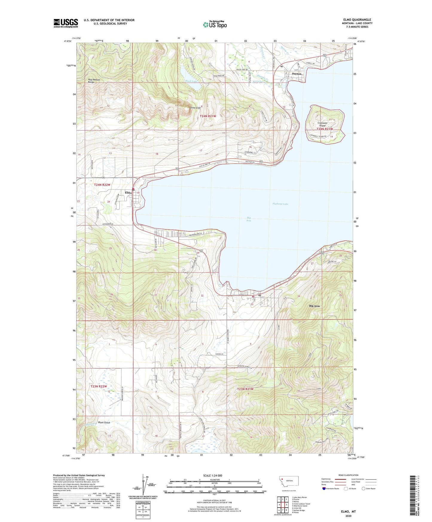
2024 topographic map quadrangle Elmo in the state of Montana. Scale: 1:24000. Based on the newly updated USGS 7.5' US Topo map series, this map is in the following counties: Lake. The map contains contour data, water features, and other items you are used to seeing on USGS maps, but also has updated roads and other features. This is the next generation of topographic maps. Printed on high-quality waterproof paper with UV fade-resistant inks.
Quads adjacent to this one:
West: Irvine Lookout Tower
Northwest: Lake Mary Ronan
North: Proctor
Northeast: Rollins
East: Wild Horse Island
Southeast: Polson
South: Buffalo Bridge
Southwest: Irvine Hill
This map covers the same area as the classic USGS quad with code o47114g3.
Contains the following named places: 23N21W04CBD_01 Well, 23N21W04CCD_01 Well, 23N21W05CDD_01 Well, 23N21W09CCD_01 Well, 23N21W09CCDA01 Well, 23N21W14BBB_01 Well, 23N21W18DBB_01 Well, 23N22W12DDC_01 Well, 24N21W02ACD_01 Well, 24N21W03CDB_01 Well, 24N21W04CDDC01 Well, 24N21W10BDCA01 Well, 24N21W16DAB_01 Well, 24N21W19BBD_01 Well, 24N21W19BCB_01 Well, 24N21W19BCCB01 Well, 24N21W26CBB_01 Well, 24N21W29ABB_01 Well, 24N21W32DDDD01 Well, 24N21W33ACC_01 Well, 24N21W33DBD_01 Well, 24N22W13DDB_01 Well, 24N22W14DDD_01 Well, 59910, 59914, Arrowhead Resort, Barnacle Bobs RV Park/Campground, Big Arm, Big Arm Campground, Big Arm Census Designated Place, Big Arm Mobile Home Park, Big Arm Post Office, Big Arm Resort and Marina, Big Arm School, Black Lake, Chief Cliff, Chief Cliff Volunteer Fire Department, Cromwell Island, Dayton, Dayton Census Designated Place, Dayton Creek, Dayton Post Office, Dayton Presbyterian Church, Dayton School, Dillons Resort and Marina, Elmo, Elmo Census Designated Place, Elmo Post Office, Elmo School, Elmo-Dayton District, Flathead Lake State Park - Big Arm Unit, Fort Lazy Y Trailer Park, Happy Landen II Resort, Indian Cemetery, Kootenai Creek, KQRK-FM (Ronan), Polson Rural Fire District - Station 2, Proctor Creek, Snowberg Court, Spring Creek, Tribal Health Department, Walstad Fishing Access Site, Walstead Park