MyTopo
Lewistown Montana US Topo Map
Couldn't load pickup availability
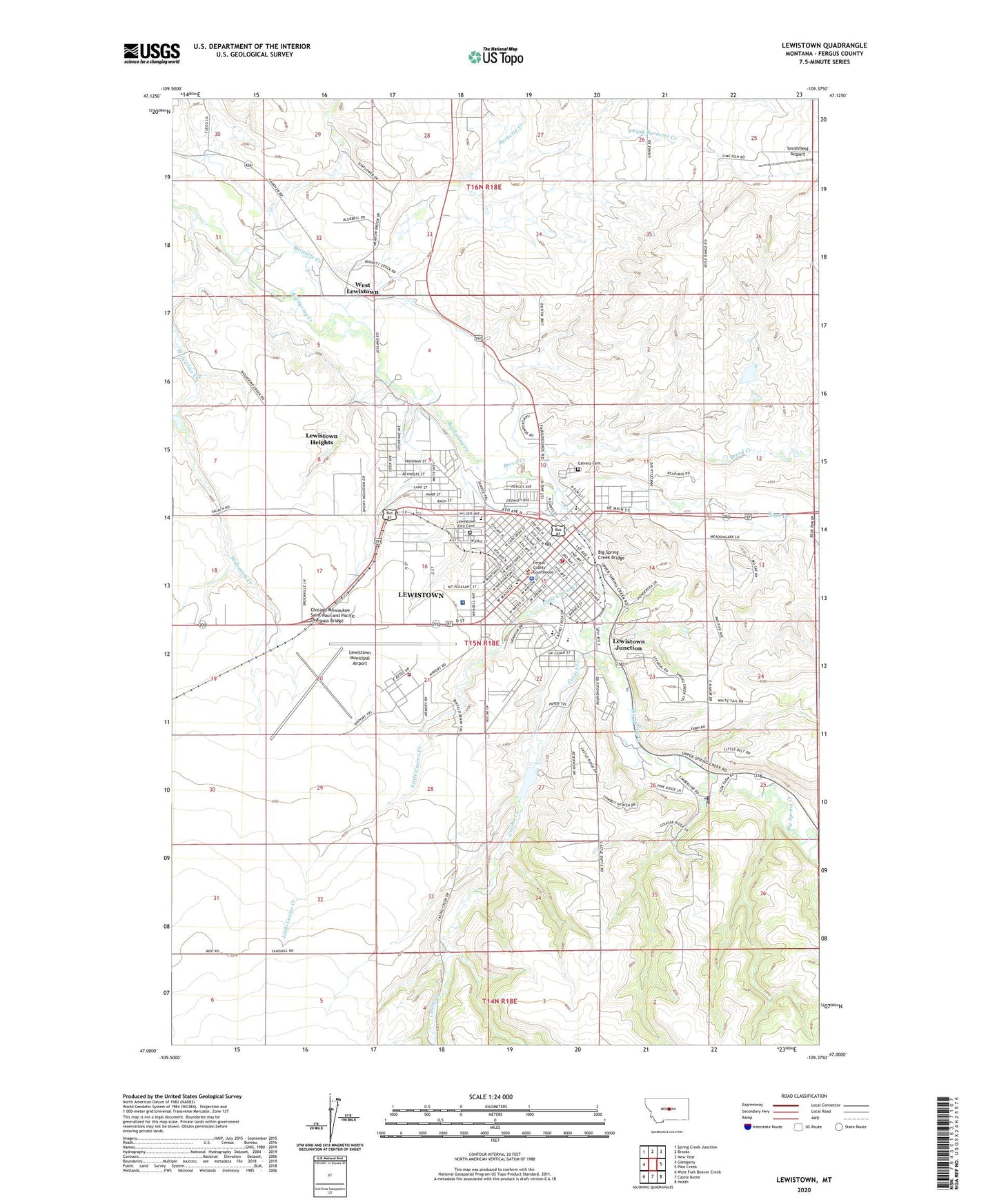
2024 topographic map quadrangle Lewistown in the state of Montana. Scale: 1:24000. Based on the newly updated USGS 7.5' US Topo map series, this map is in the following counties: Fergus. The map contains contour data, water features, and other items you are used to seeing on USGS maps, but also has updated roads and other features. This is the next generation of topographic maps. Printed on high-quality waterproof paper with UV fade-resistant inks.
Quads adjacent to this one:
West: Glengarry
Northwest: Spring Creek Junction
North: Brooks
Northeast: New Year
East: Pike Creek
Southeast: Heath
South: Castle Butte
Southwest: West Fork Beaver Creek
This map covers the same area as the classic USGS quad with code o47109a4.
Contains the following named places: 14N18E01DBAD01 Well, 14N18E04DBB_01 Well, 15N17E31ACBD01 Well, 15N18E04DCCA01 Well, 15N18E05ADAA01 Well, 15N18E05ADAA02 Well, 15N18E07DDBC01 Well, 15N18E09BBAB01 Well, 15N18E09CADA01 Well, 15N18E09CBC_01 Well, 15N18E09CCAA01 Well, 15N18E09CD__01 Well, 15N18E09DBAD01 Well, 15N18E10BAA_01 Well, 15N18E11AACC01 Well, 15N18E11DCB_01 Well, 15N18E12CBAA01 Well, 15N18E13AAC_01 Well, 15N18E14CD__01 Well, 15N18E14CDAD01 Well, 15N18E14DB__01 Well, 15N18E15ADD_01 Well, 15N18E15BBBA01 Well, 15N18E16AB__01 Well, 15N18E16CCC_01 Well, 15N18E16CDD_01 Well, 15N18E16DCCC01 Well, 15N18E16DDBB01 Well, 15N18E16DDBC01 Well, 15N18E17AAB_01 Well, 15N18E18DCC_01 Well, 15N18E20AAAB01 Well, 15N18E22ADDA01 Well, 15N18E22BAA_01 Well, 15N18E22BBBB01 Well, 15N18E22BBBC01 Well, 15N18E22BDDA01 Well, 15N18E22CCC_01 Well, 15N18E23BAB_01 Well, 15N18E23BABB01 Well, 15N18E23BDBC01 Well, 15N18E23BDCA01 Well, 15N18E23BDCD01 Well, 15N18E25ADC_01 Well, 15N18E25CBCB01 Well, 15N18E25CBCB02 Well, 15N18E26CCBA01 Well, 15N18E26CCDA01 Well, 15N18E26CCDC01 Well, 15N18E26DB__01 Well, 15N18E26DBBA01 Well, 15N18E27AA__01 Well, 15N18E27BBBB01 Well, 15N18E33ACA_01 Well, 15N18E33ACAB01 Well, 15N18E33ACBB01 Well, 15N18E33DCDC01 Well, 15N18E35AABA01 Well, 16N18E32DCB_01 Well, 16N18E32DCD_01 Well, 16N18E33ACAD01 Well, 16N18E33ACAD02 Well, 16N18E33CCB_01 Well, Akerville, Assembly of God Church, Big Casino Creek Dam, Big Casino Creek Reservoir Fishing Access Site, Big Spring Creek Bridge, Boyd Creek, Breed Creek, Brewery Flats Fishing Access Site, Bureau of Land Management Fire Dispatch, Burnette Creek, Butcher Dam, Calvary Cemetery, Calvary Community Church, Camp Lewis, Carroll Trail Fishing Access Site, Casino Creek, Central Baptist Church, Central Montana Christian School, Central Montana Historical Society and Museum, Central Montana Hospital and Nursing Home Heliport, Central Montana Medical Center, Chicago Milwaukee Saint Paul and Pacific Overpass Bridge, Christian and Missionary Alliance Church, Christian Science Society, Church of Christ, Church of God, Church of the Nazarene, City of Lewistown, Community Chiropractic Clinic, D'Autremont Complex, Elks Country Club, Emmanuel Baptist Church, Fergus Athletic Field, Fergus County Courthouse, Fergus County Fairgrounds, Fergus County Sheriff's Department, Fergus High School, First Baptist Church, First Christian Church, First Presbyterian Church, Fort Sherman, Frank Day Park, Fred Robinson Park, Garfield Elementary School, Gillett Landing Strip, Harvest States Cooperatives Elevator, Hawthorne Park, Highland Park Elementary School, Janeauxs Post, Jaycees Park, Judith Basin Country Historical Marker, Judith Park, Kingdom Hall of Jehovahs Witness, Kiwanis Club Campground, Kiwanis Park, KLCM-FM (Lewistown), KXLO-AM (Lewistown), Lewis and Clark Elementary School, Lewistown, Lewistown Army Air Field, Lewistown City Cemetery, Lewistown Elks Country Club, Lewistown Fire Rescue, Lewistown Heights, Lewistown Heights Census Designated Place, Lewistown Historical Marker, Lewistown Junction, Lewistown Junior High School, Lewistown Municipal Airport, Lewistown Police Department, Lewistown Post Office, Lewistown Public Library, Lincoln School, Little Casino Creek, Mental Health Center, Mill Ditch Park, Montana Center for the Aged, Mountain Acres Mobile Home Park, Mountain Acres RV Park and Campground, Puppie Tail Dam, Reed and Bowles Trading Post, Reedsfort Post Office, Roy-Winifred Junction, Saint James Episcopal Church, Saint Leos Catholic Church, Saint Marys School, Saint Pauls Lutheran Church, Sawyers Trailer Park, Schroder Hospital, Seventh Day Adventist Church, Smithfield Airport, South Fork Burnette Creek, Spring Creek Fishing Access Site, Sunrise Personal Care Home, Symmes Park, The Church of Jesus Christ of Latter Day Saints, United Methodist Church, Valle Vista Manor, Valley View Castle Mobile Home Park, West Lewistown, Westernaire Drive-In Theater, WIC Clinic, Wolverine Creek, Zion Lutheran Church