MyTopo
Saint Ignatius Montana US Topo Map
Couldn't load pickup availability
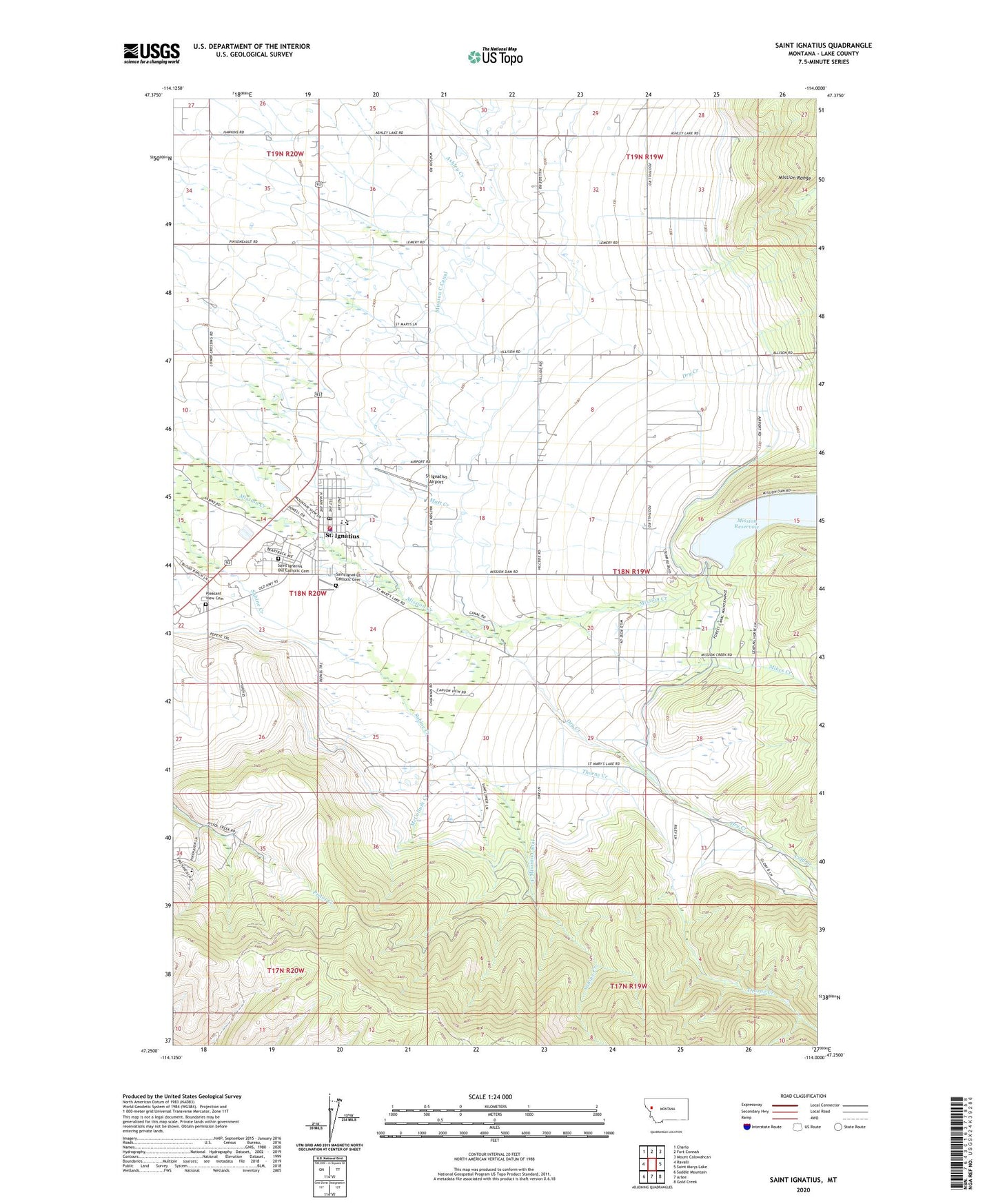
2024 topographic map quadrangle Saint Ignatius in the state of Montana. Scale: 1:24000. Based on the newly updated USGS 7.5' US Topo map series, this map is in the following counties: Lake. The map contains contour data, water features, and other items you are used to seeing on USGS maps, but also has updated roads and other features. This is the next generation of topographic maps. Printed on high-quality waterproof paper with UV fade-resistant inks.
Quads adjacent to this one:
West: Ravalli
Northwest: Charlo
North: Fort Connah
Northeast: Mount Calowahcan
East: Saint Marys Lake
Southeast: Gold Creek
South: Arlee
Southwest: Saddle Mountain
This map covers the same area as the classic USGS quad with code o47114c1.
Contains the following named places: 18N19W04DDBB01 Well, 18N19W05BBC_01 Well, 18N19W05CCC_01 Well, 18N19W06CBC_01 Well, 18N19W08CBC_01 Well, 18N19W10BCCC01 Well, 18N19W17ADD_01 Well, 18N19W17BBBB01 Well, 18N19W19ADC_01 Well, 18N19W19CBAC01 Well, 18N19W19CBCB01 Well, 18N19W19CCB_01 Well, 18N19W20ACA_01 Well, 18N19W21BBD_01 Well, 18N19W22CADD01 Well, 18N19W28CCDB01 Well, 18N19W29DACC01 Well, 18N19W30ADA_01 Well, 18N19W30CCCA01 Well, 18N19W30DCBB01 Well, 18N20W01CCAC01 Well, 18N20W02AAAD01 Well, 18N20W02CDD_01 Well, 18N20W10ADD_01 Well, 18N20W11DDA_01 Well, 18N20W12CCC_01 Well, 18N20W12DDD_01 Well, 18N20W13DCCD01 Well, 18N20W14DBD_01 Well, 18N20W14DBD_02 Well, 18N20W14DBDC01 Well, 18N20W14DCA_01 Well, 18N20W15DCAD01 Well, 18N20W23DADA01 Well, 18N20W25ADA_01 Well, 18N20W25DBDD01 Well, 19N19W28CDD_01 Well, 19N19W29CDC_01 Well, 19N20W25DDD_01 Well, 19N20W27DDD_01 Well, 19N20W35AAA_01 Well, 19N20W36ABB_01 Well, 59865, Assembly of God Church, Christian and Missionary Alliance Church, Cold Creek, Doug Allards Flathead Indian Museum, Dry Creek, F Mission Canal, Four Winds Historical Village, Industrial Arts School, Kingdom Hall of Jehovahs Witnesses, McCollum Creek, Medicine Tree, Mikes Creek, Mission B Canal, Mission C Canal, Mission Dam, Mission District, Mission Hospital, Mission Reservoir, Mission Valley Ambulance, Mission Valley Health Center, Pinehaven Christian Children's Ranch and School, Pleasant View Cemetery, Saint Ignatius, Saint Ignatius Camping, Saint Ignatius Catholic Cemetery, Saint Ignatius Christian Church, Saint Ignatius Elementary School, Saint Ignatius Fire Department, Saint Ignatius Mission, Saint Ignatius Mission Church, Saint Ignatius Old Catholic Cemetery, Saint Ignatius Police Department, Saint Ignatius Post Office, Saint Ignatius Public Library, Saint Joseph School, St Ignatius Airport, Statue of the Sacred Heart, Taelman Park, The Church of Jesus Christ of Latter day Saints, Thorne Creek, Town of Saint Ignatius, United Methodist Church, Villa Ursula, Zion Lutheran Church