MyTopo
Arlee Montana US Topo Map
Couldn't load pickup availability
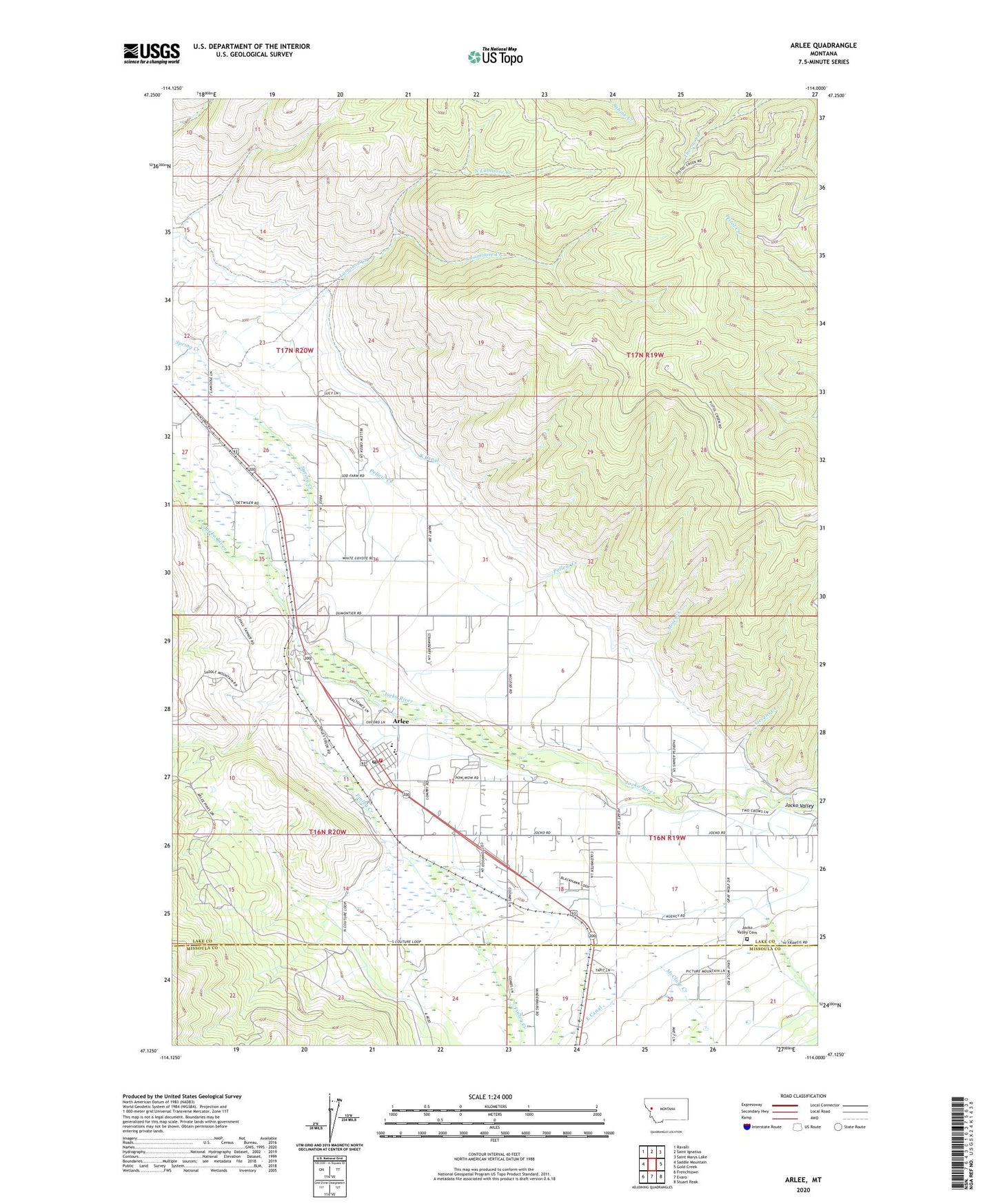
2024 topographic map quadrangle Arlee in the state of Montana. Scale: 1:24000. Based on the newly updated USGS 7.5' US Topo map series, this map is in the following counties: Lake, Missoula. The map contains contour data, water features, and other items you are used to seeing on USGS maps, but also has updated roads and other features. This is the next generation of topographic maps. Printed on high-quality waterproof paper with UV fade-resistant inks.
Quads adjacent to this one:
West: Saddle Mountain
Northwest: Ravalli
North: Saint Ignatius
Northeast: Saint Marys Lake
East: Gold Creek
Southeast: Stuart Peak
South: Evaro
Southwest: Frenchtown
This map covers the same area as the classic USGS quad with code o47114b1.
Contains the following named places: 16N19W06BBB_01 Well, 16N19W06CCBB01 Well, 16N19W07AAB_01 Well, 16N19W07DBCA01 Well, 16N19W08ACBD01 Well, 16N19W08CADB01 Well, 16N19W08DCAA01 Well, 16N19W08DCAA02 Well, 16N19W08DCAA03 Well, 16N19W08DCAA04 Well, 16N19W08DCAA05 Well, 16N19W08DCAA06 Well, 16N19W08DCD_01 Well, 16N19W09BCAD01 Well, 16N19W09CADB01 Well, 16N19W09CCAB01 Well, 16N19W09CCAB02 Well, 16N19W09CDBA01 Well, 16N19W09DDCC01 Well, 16N19W16BABA01 Well, 16N19W16CCA_01 Well, 16N19W16DCCD01 Well, 16N19W16DDCA01 Well, 16N19W18AABD01 Well, 16N19W18BBAA01 Well, 16N19W18BBBC01 Well, 16N19W18BCA_01 Well, 16N19W19DCA_01 Well, 16N19W20CAAD01 Well, 16N19W20DDA_01 Well, 16N20W01BCC_01 Well, 16N20W01CABA01 Well, 16N20W02BBDD01 Well, 16N20W02CDD_01 Well, 16N20W10CCBA01 Well, 16N20W11AAC_01 Well, 16N20W11AAD_01 Well, 16N20W11ADDC01 Well, 16N20W11DAAA01 Well, 16N20W11DAAB01 Well, 16N20W11DBBD01 Well, 16N20W12BBBD01 Well, 16N20W12CBB_01 Well, 16N20W12CDAB01 Well, 16N20W13ACAC01 Well, 16N20W13CCC_01 Well, 16N20W24ABA_01 Well, 17N19W31BCC_01 Well, 17N20W25CBD_01 Well, 17N20W25CCCA01 Well, 17N20W26DCAA01 Well, 17N20W26DCC_01 Well, 17N20W27ACA_01 Well, 17N20W27ADC_01 Well, 17N20W35BAAA01 Well, 17N20W35BDAD01 Well, 17N20W35DABD01 Well, 17N20W36BBBA01 Well, 22N20W26AAAA01 Well, 22N20W36BBAB01 Well, 59821, Agency Creek, Agency Post Office, Arlee, Arlee Alliance Church, Arlee Ambulance Service, Arlee Census Designated Place, Arlee District, Arlee Post Office, Arlee Public Schools, Arlee Volunteer Fire Department, E Canal, Finley Creek, FIP_CANAL_____ Well, Flat Head Post Office, Hurley, Jocko Agency School, Jocko Hollow Campground, Jocko Post Office, Jocko Valley Cemetery, Jocko Valley Historical Marker, Jocko Valley Library, Jocko Valley Lutheran Church, K Canal, Lamoose Creek, McClure Creek, Medicine Tree, Mission Church, Moiese Creek, North Lamoose Creek, Pellew Creek, R Canal, Sacred Heart Mission, South Lamoose Creek, Stevens Creek