MyTopo
Stuart Peak Montana US Topo Map
Couldn't load pickup availability
Also explore the Stuart Peak Forest Service Topo of this same quad for updated USFS data
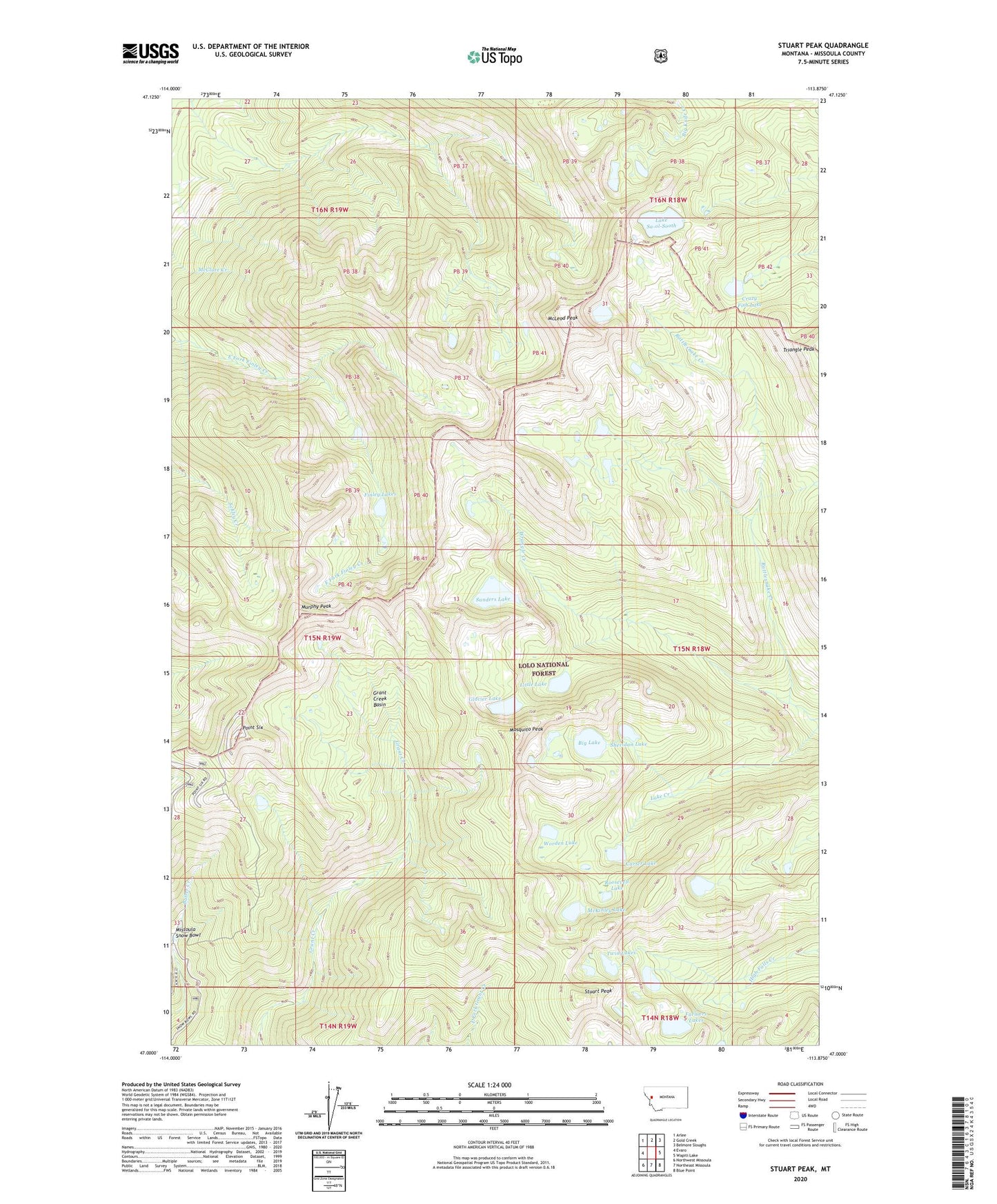
2024 topographic map quadrangle Stuart Peak in the state of Montana. Scale: 1:24000. Based on the newly updated USGS 7.5' US Topo map series, this map is in the following counties: Missoula. The map contains contour data, water features, and other items you are used to seeing on USGS maps, but also has updated roads and other features. This is the next generation of topographic maps. Printed on high-quality waterproof paper with UV fade-resistant inks.
Quads adjacent to this one:
West: Evaro
Northwest: Arlee
North: Gold Creek
Northeast: Belmore Sloughs
East: Wapiti Lake
Southeast: Blue Point
South: Northeast Missoula
Southwest: Northwest Missoula
This map covers the same area as the classic USGS quad with code o47113a8.
Contains the following named places: Angle Face Ski Trail, Big Lake, Big Lake Number 3 Dam, Big Sky Ski Trail, Bowl Outrun Ski Trail, Carter Lake, Carter Lake Dam, Centennial Trail Ski Trail, Chicken Chute Ski Trail, Crazy Fish Lake, East Bowls Ski Trail, Far East Ski Trail, Farmers Lakes, Finley Lakes, First Run Ski Trail, Foxtrot Ski Trail, Glacier Lake, Glacier Lake Dam, Grandstand Ski Trail, Grant Creek Basin, Grizzly Chute Ski Trail, Grizzly Ski Trail, High Roller Ski Trail, Huckleberry Ski Trail, KDXT-FM (Missoula), KUFM-FM (Missoula), KYSS-FM (Missoula), Lake Sa-ol-Sooth, Levitation Ski Trail, Little Lake, Little Lake Dam, Longhorn Ski Trail, Lower High Park Ski Trail, Lower Hot Fudge Ski Trail, Lower Lake Dam Number 2, Lower Lake of Twin Lakes, Lower Paradise Ski Trail, Lower Second Thought Ski Trail, Lower Sunrise Bowl Ski Trail, McKinley Lake, McKinley Lake Dam, McLeod Peak, Mission Magic Ski Trail, Missoula County, Missoula Snow Bowl, Mogul Alley Ski Trail, Montana Snow Bowl Ski Area, Mosquito Peak, Murphy Peak, North Dakota Downhill Ski Trail, Point Six, Purgatory Ski Trail, Rattlesnake Wilderness, Roosevelt Lake, Sanders Lake, Sanders Lake Dam Number 1, Sanders Lake Dam Number 2, Second Thought Ski Trail, Sheridan Lake, Sheridan Lake Dam Number 2, Spartan Headwall Ski Trail, Stuart Peak, Time Out Cat Walk Ski Trail, Triangle Peak, Twin Lakes, Upper High Park Ski Trail, Upper Hot Fudge Ski Trail, Upper Lake, Upper Paradise Ski Trail, Upper Second Thought Ski Trail, Upper Spartan Ski Trail, Upper Sunrise Bowl Ski Trail, Upper Twin Lake Dam, West Bowls Ski Trail, West Ridge Ski Trail, Whipped Cream Ski Trail, Worden Lake, Worden Lake Dam, Wrangle Creek