MyTopo
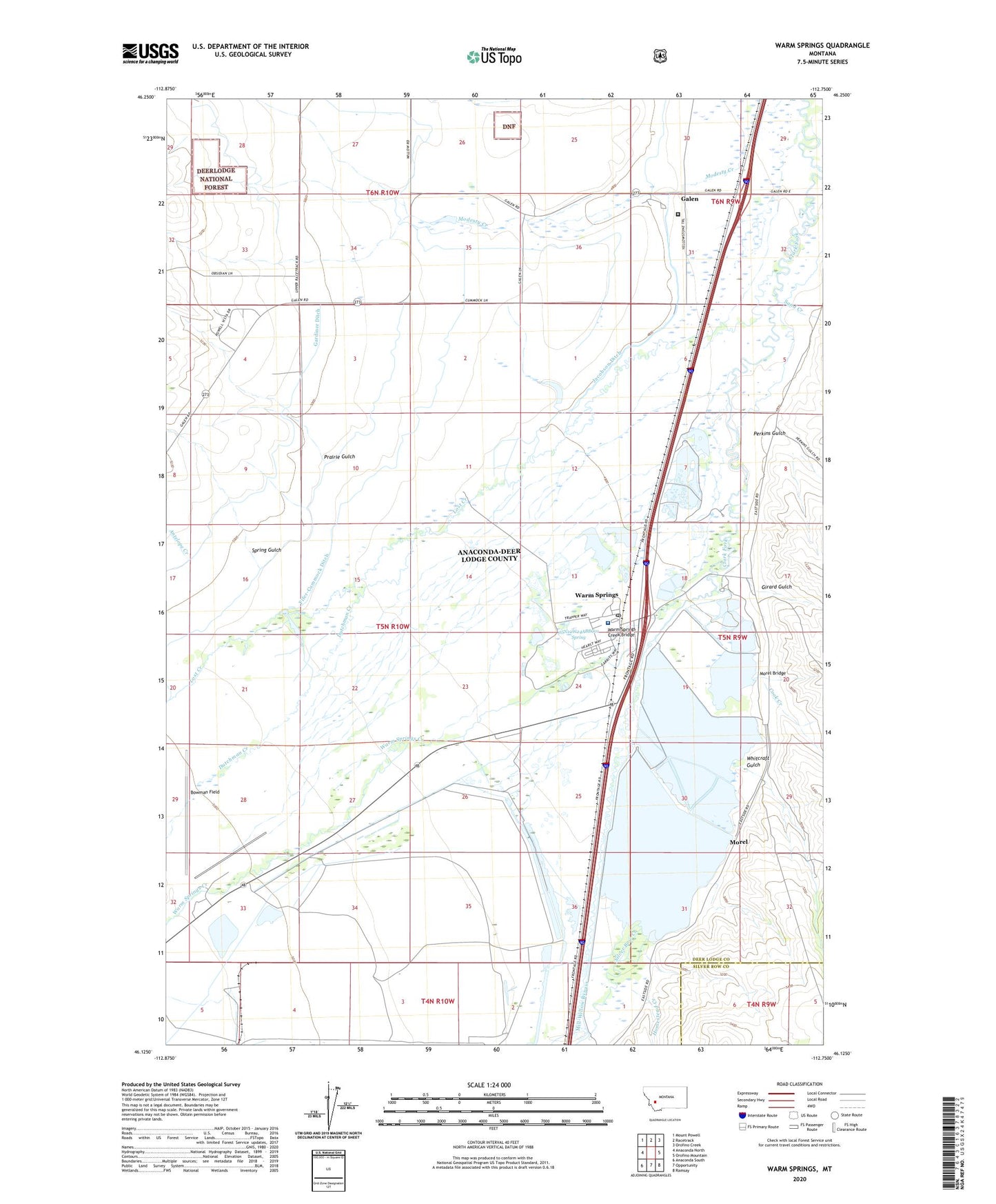
Warm Springs Montana US Topo Map
Couldn't load pickup availability
Also explore the Warm Springs Forest Service Topo of this same quad for updated USFS data
2024 topographic map quadrangle Warm Springs in the state of Montana. Scale: 1:24000. Based on the newly updated USGS 7.5' US Topo map series, this map is in the following counties: Deer Lodge, Silver Bow. The map contains contour data, water features, and other items you are used to seeing on USGS maps, but also has updated roads and other features. This is the next generation of topographic maps. Printed on high-quality waterproof paper with UV fade-resistant inks.
Quads adjacent to this one:
West: Anaconda North
Northwest: Mount Powell
North: Racetrack
Northeast: Orofino Creek
East: Orofino Mountain
Southeast: Ramsay
South: Opportunity
Southwest: Anaconda South
This map covers the same area as the classic USGS quad with code o46112b7.
Contains the following named places: 04N10W05AACC01 Well, 04N10W05AACC02 Well, 04N10W05AB__01 Well, 05N09W05BA__01 Well, 05N09W05CDAD01 Well, 05N09W05CDBB01 Well, 05N09W05CDDD01 Well, 05N09W07CAAC01 Well, 05N09W07CB__01 Well, 05N09W07DABC01 Well, 05N09W07DCCC01 Well, 05N09W07DCDC01 Well, 05N09W08BCAB01 Well, 05N09W17BC__01 Well, 05N09W17BCCA01 Well, 05N09W17BCDB01 Well, 05N09W17BCDC01 Well, 05N09W17CACA01 Well, 05N09W18AB__01 Well, 05N09W18ADCD01 Well, 05N09W18ADCD02 Well, 05N09W24ABAA01 Well, 05N09W29BC__01 Well, 05N10W02AA__01 Well, 05N10W02AAAB01 Well, 05N10W03AA__01 Well, 05N10W03BBBB01 Well, 05N10W03CB__01 Well, 05N10W03CBCC01 Well, 05N10W03DD__01 Well, 05N10W04AA__01 Well, 05N10W10CB__01 Well, 05N10W10CCBC01 Well, 05N10W13BC__01 Well, 05N10W13DA__01 Well, 05N10W14DC__01 Well, 05N10W15BA__01 Well, 05N10W16AC__01 Well, 05N10W16DC__01 Well, 05N10W22DD__01 Well, 05N10W23DC__01 Well, 05N10W23DD__01 Well, 05N10W23DDCD01 Well, 05N10W24AA__01 Well, 05N10W24ABBC01 Spring, 05N10W24CB__01 Well, 05N10W24DA__01 Well, 05N10W25DA__01 Well, 05N10W27DADA01 Well, 05N10W27DCBD01 Well, 05N10W33AB__01 Well, 05N10W33BCCC01 Well, 05N10W33BCDB01 Well, 05N10W33DA__01 Well, 06N09W29AC__01 Well, 06N09W29BB__01 Well, 06N09W30AB__02 Well, 06N09W30CD__01 Well, 06N09W31BB__01 Well, 06N09W31CD__01 Well, 06N09W31CDAB01 Well, 06N09W31DD__01 Well, 06N10W26DC__01 Well, 06N10W27CCCC01 Well, 06N10W34AD__01 Well, 06N10W35AB__01 Well, 59756, Babcock Dam, Beck Ditch, Beckstead Ditch, Bowman Field, Cook Creek, Dry Cottonwood Creek, Dutchman Creek, Fifer-Cummock Ditch, Fredrickson, Galen, Galen Spur, Gardiner Ditch, Girard Gulch, Heapby Reservoir Dam, Homestead Creek, Jacobson Ditch, Lost Creek, Mill-Willow Bypass, Montana State Hospital, Montana State Hospital Galen Campus, Montana State Hospital Warm Springs Campus, Morel, Morel Bridge, Opportunity Tailings Ponds Dam, Perkins Gulch, Prairie Gulch, Reintegrating Youthful Offenders Juvenile Correctional Facility, Ruby Mine, Sand Creek, Silver Bow Creek, Spring Gulch, Warm Springs, Warm Springs Bridge Fishing Access Site, Warm Springs Creek, Warm Springs Creek Bridge, Warm Springs Division, Warm Springs Post Office, Warm Springs School, Warm Springs State Wildlife Management Area, Warm Springs Tailing Dam Number 1, Warm Springs Tailing Dam Number 2, Warm Springs Tailing Dam Number 3, Whitcraft Gulch, Willow Glen School, Willowglen Post Office