MyTopo
Wolf Point Montana US Topo Map
Couldn't load pickup availability
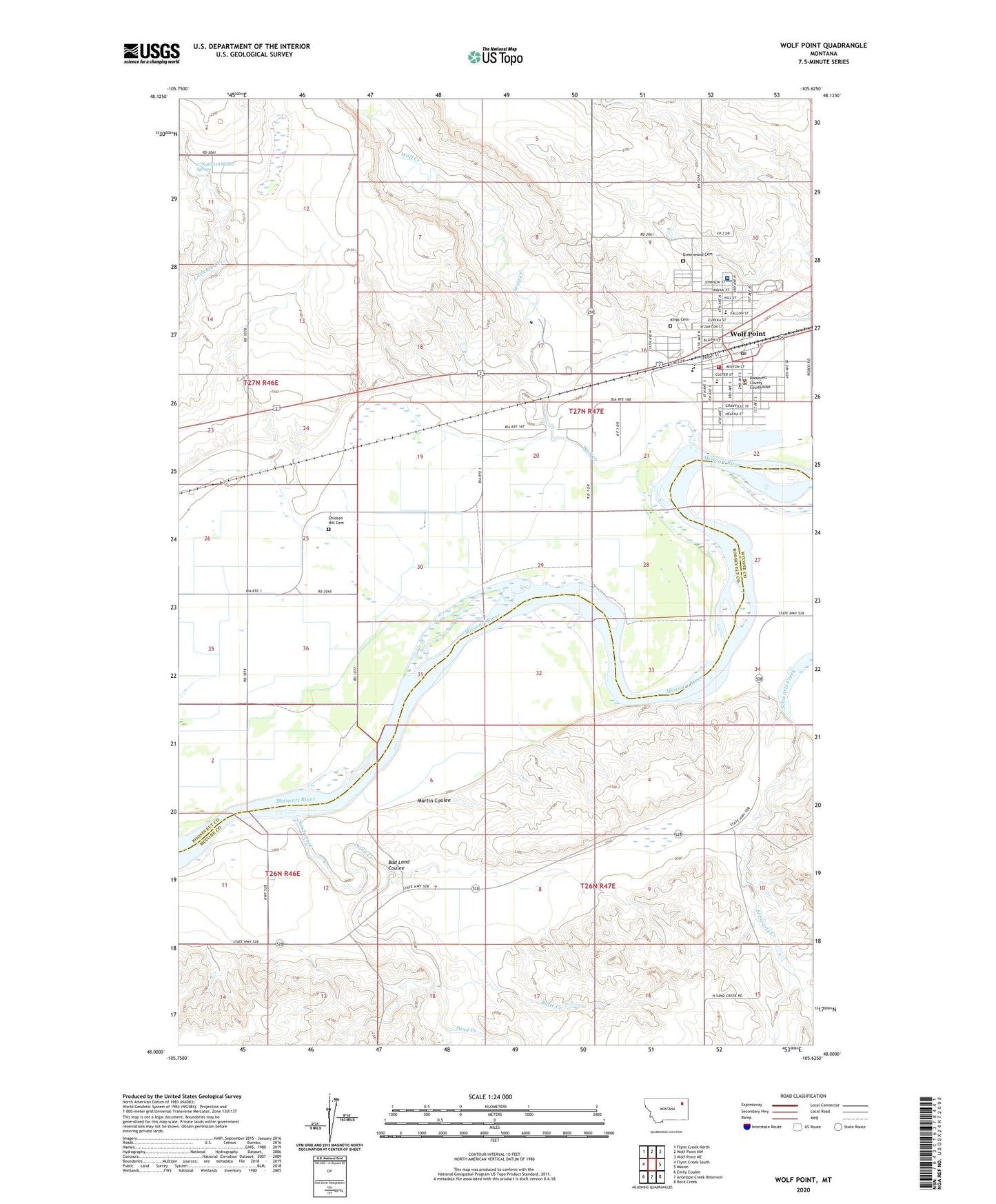
2024 topographic map quadrangle Wolf Point in the state of Montana. Scale: 1:24000. Based on the newly updated USGS 7.5' US Topo map series, this map is in the following counties: Roosevelt, McCone. The map contains contour data, water features, and other items you are used to seeing on USGS maps, but also has updated roads and other features. This is the next generation of topographic maps. Printed on high-quality waterproof paper with UV fade-resistant inks.
Quads adjacent to this one:
West: Flynn Creek South
Northwest: Flynn Creek North
North: Wolf Point NW
Northeast: Wolf Point NE
East: Macon
Southeast: Rock Creek
South: Antelope Creek Reservoir
Southwest: Emily Coulee
This map covers the same area as the classic USGS quad with code o48105a6.
Contains the following named places: 26N46E01BA__01 Well, 26N46E01BA__02 Well, 26N46E01DA__01 Well, 26N46E01DA__02 Well, 26N46E02AA__01 Well, 26N46E02AB__01 Well, 26N46E11DD__03 Well, 26N46E12BB__01 Well, 26N46E13AA__01 Well, 26N46E14AA__01 Well, 26N46E14AA__02 Well, 26N46E14BA__01 Well, 26N46E14BA__02 Well, 26N47E06CB__01 Well, 26N47E09AA__01 Well, 26N47E10BA__01 Well, 26N47E10BC__01 Well, 27N46E11ABCB01 Spring, 27N46E11DD__01 Well, 27N46E11DD__02 Well, 27N46E11DD__04 Well, 27N46E13BB__01 Well, 27N46E14AA__01 Well, 27N46E23AAAB01 Well, 27N46E24BB__01 Well, 27N46E24CB__01 Well, 27N46E25AD__01 Well, 27N46E25BA__01 Well, 27N46E35AA__01 Well, 27N46E36AA__01 Well, 27N46E36AC__01 Well, 27N46E36AC__02 Well, 27N47E03BC__01 Well, 27N47E03BC__02 Well, 27N47E03BC__03 Well, 27N47E03CD__01 Well, 27N47E04BDBB01 Well, 27N47E04DA__01 Well, 27N47E09DD__01 Well, 27N47E09DD__02 Well, 27N47E10BD__01 Well, 27N47E15AB__01 Well, 27N47E15AC__01 Well, 27N47E15BD__01 Well, 27N47E15CB__01 Well, 27N47E15CB__02 Well, 27N47E17AC__01 Well, 27N47E17AC__02 Well, 27N47E17AC__03 Well, 27N47E17BD__01 Well, 27N47E17BD__02 Well, 27N47E17DD__01 Well, 27N47E19AD__01 Well, 27N47E19AD__02 Well, 27N47E19AD__03 Well, 27N47E19BB__01 Well, 27N47E19DC__01 Well, 27N47E20AC__01 Well, 27N47E20BC__01 Well, 27N47E20DC__01 Well, 27N47E20DD__01 Well, 27N47E20DD__02 Well, 27N47E21DDDA01 Well, 27N47E22BB__01 Well, 27N47E27DB__01 Well, 27N47E30AABD01 Well, 27N47E30DB__01 Well, 27N47E34CA__01 Well, 27N47E34DB__01 Well, 27N47E34DC__01 Well, Anderson Private Field, Assembly of God Church, Bad Land Coulee, Blue Sky Ministries, Borge Park, Burnison Maternity Hospital, Butte Creek, Canipa Presbyterian Church, Chicken Hill Cemetery, Church of Christ, City of Wolf Point, Community Bible Church, Cusker School, Equity Co-op Association Elevator, Faith Lutheran Home, Firehall Park, First Baptist Church, First Lutheran Church, First Presbyterian Church, General Mills Incorporated Elevator, Good Shepherd Lutheran Church, Gospel Fellowship Church, Greenwood Cemetery, Harvest States Cooperatives Elevator, Immaculate Conception Catholic Church, Immaculate Conception School, Jehovah's Witnesses, Kings Cemetery, KTYZ-AM (Wolf Point), Listerud Clinic, Littleman Creek, Martin Coulee, Moes Trailer Court, Morning Star Baptist Church, Nellies Park, Northeast Montana Medical Group, Northside School, Peavey Company Elevator, Rancho Campground and Motel, Roosevelt County Courthouse, Roosevelt County Fire Department, Roosevelt County Library, Roosevelt County Sheriff's Office, Sand Creek, Schwartz Creek, Sherman Park, Southside School, Sundown Drive-In, The Church of Jesus Christ of Latter Day Saints, Triangle Park, Trinity Hospital, Trinity Lutheran Church, Tyner Post Office, United Dakota Presbyterian Church, Wolf Creek, Wolf Point, Wolf Point Area Historical Society Museum, Wolf Point High School, Wolf Point Historical Marker, Wolf Point Police Department, Wolf Point Post Office, Wolf Point Sewage Lagoon Dam, Wolf Point Volunteer Fire Department