MyTopo
Plattsmouth Nebraska US Topo Map
Couldn't load pickup availability
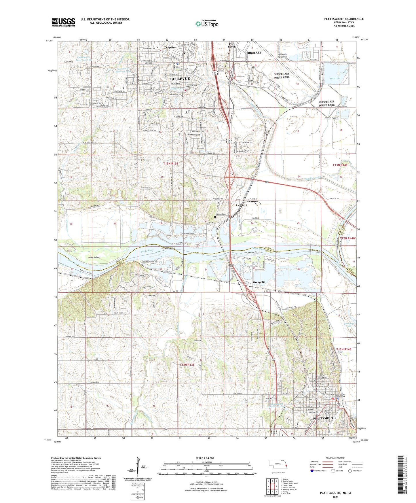
2021 topographic map quadrangle Plattsmouth in the state of Nebraska. Scale: 1:24000. Based on the newly updated USGS 7.5' US Topo map series, this map is in the following counties: Sarpy, Cass, Mills. The map contains contour data, water features, and other items you are used to seeing on USGS maps, but also has updated roads and other features. This is the next generation of topographic maps. Printed on high-quality waterproof paper with UV fade-resistant inks.
Quads adjacent to this one:
West: Cedar Creek
Northwest: Ralston
North: Omaha South
Northeast: Council Bluffs South
East: Pacific Junction
Southeast: Rock Bluff
South: Murray
Southwest: Weeping Water NE
This map covers the same area as the classic USGS quad with code o41095a8.
Contains the following named places: Accent Mobile Home Parks, Base Lake, Bay Hills Golf Course, Bellevue Fire Department - District 4 Station, Bellevue Historical Marker, Bellevue Loop Trail, Bellevue Second III Election Precinct, Bellevue Second IV Election Precinct, Bester School, Cass County Courthouse, Cass County Historical Museum, Cass County Sheriff's Office, Cedar Island, Central School, Church of Christ, Church of the Holy Spirit, City of Plattsmouth, Columbian Elementary School, Company A - First Nebraska Infantry Historical Marker, Dentention Dam 10-A, Ehrling Bergquist Medical Clinic, Eightmile Creek, Eppley Camp, Eye Specialties, Fairview Creek, Faith Alliance Church, First Baptist Church, First Christian Church, First Lutheran Church, First Presbyterian Church, First United Methodist Church, Fort Creek School, Fort Crook Elementary School, Fourmile Creek, Frasher School, Garfield Park, Grade Stabilization Dam S-32, Hefner Chiropractic Center, Hill City Mobile Home Park, HiVue Mobile Home Park, Hosanna Lutheran Church, Immanuel Camp, Kansas-Nebraska Convention of Southern Baptist, Kingdom Hall of Jehovahs Witnesses, KOTD-AM (Plattsmouth), KZPG-FM (Plattsmouth), La Platte, La Platte Cemetery, La Platte Census Designated Place, La Platte Election Precinct, La Platte Post Office, LaPlatte I Election Precinct, LaPlatte II Election Precinct, LaPlatte School, Larimer City Post Office, Larimer Mills Post Office, Leawood Oaks II Park, Leonard Lawrence Elementary School, Lewis and Clark Camp Site Historical Marker, Living Truth Fellowship Church, Memorial Park, Merrill Mission, Moses Merrill Mission Site, New Life Assembly of God Church, North Whitted Creek, Oak Hill Cemetery, Offutt Air Force Base, Offutt Air Force Base Catholic Church, Offutt Air Force Base Census Designated Place, Offutt Air Force Base Post Office, Offutt Fire Department, Oreapolis, Oreapolis Post Office, Oto Mission Historical Marker, Papillion Creek Dam S-31, Papillion Creek Reservoir S-31, Papillion Creek Reservoir S-32, Pappio, Paradise Park, Peter Sarpy Elementary School, Platte River, Platteview Country Club, Plattsmouth, Plattsmouth Chiropractic Center, Plattsmouth Country Club, Plattsmouth Election Precinct, Plattsmouth Elementary School, Plattsmouth Family Dentistry, Plattsmouth Family Physicians, Plattsmouth High School, Plattsmouth Manor, Plattsmouth Police Department, Plattsmouth Post Office, Plattsmouth Public Library, Plattsmouth Reservoir 10-A, Plattsmouth Volunteer Fire Department, Plattsmouth Volunteer Rescue Squad, Rhylander Park, Saint John the Baptist School, Saint Lukes Episcopal Church, Saint Matthew the Evangelist Catholic Church, Saint Pauls United Church of Christ, Sands Trailer Park, Schilling State Wildlife Area, Stull School, Taylor School, Thiering School, Thomas S Power Base Library, Tregaron Golf Course, Trumble School, Two Springs Elementary School, University Medical Associates of Plattsmouth Building, Warrior Nine Golf Course, Wesleyan Church, Whitted Creek, Willow Lakes Golf Course, Zwiebel Creek, ZIP Codes: 68113, 68123, 68133