MyTopo
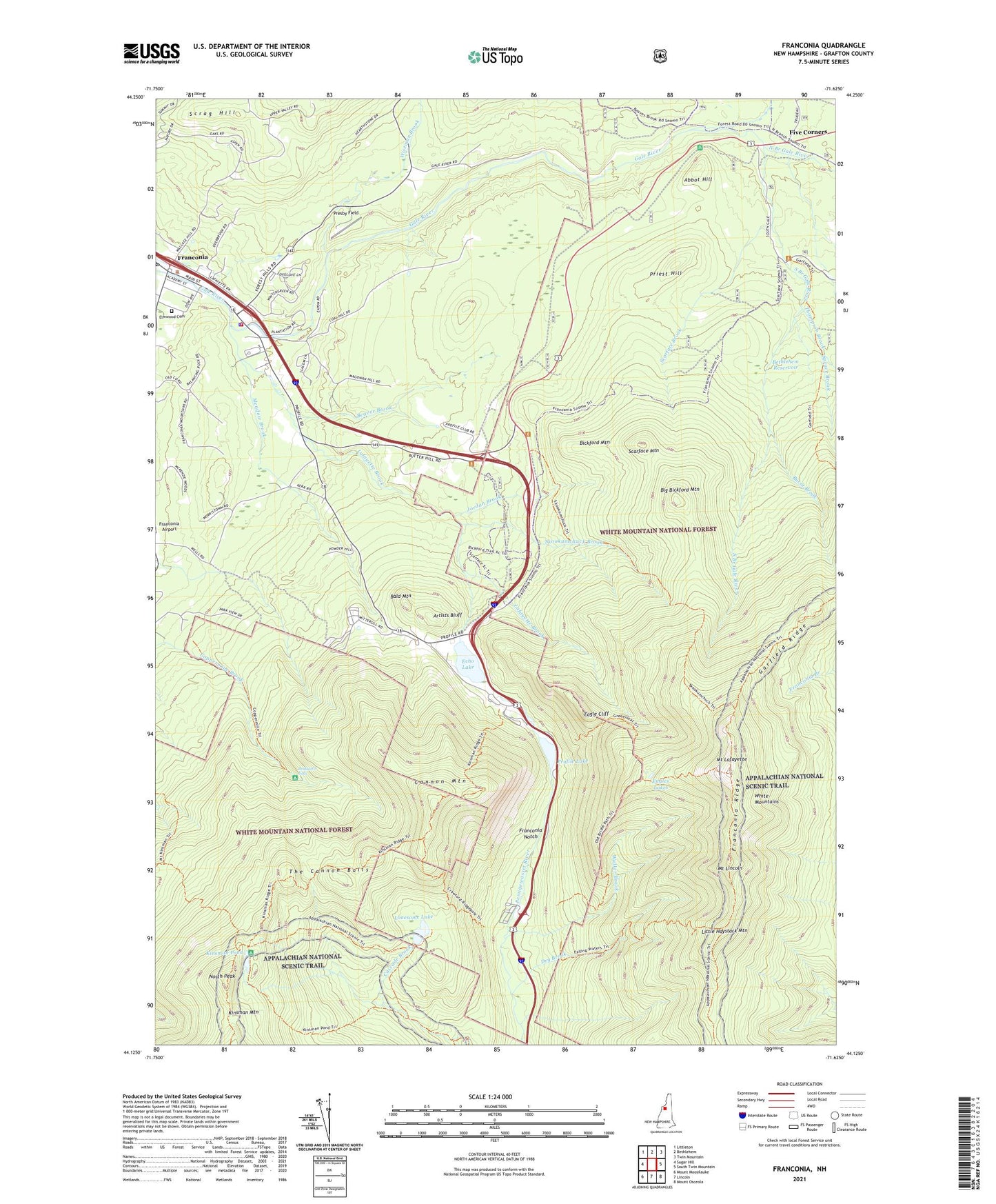
Franconia New Hampshire US Topo Map
Couldn't load pickup availability
Also explore the Franconia Forest Service Topo of this same quad for updated USFS data
2024 topographic map quadrangle Franconia in the state of New Hampshire. Scale: 1:24000. Based on the newly updated USGS 7.5' US Topo map series, this map is in the following counties: Grafton. The map contains contour data, water features, and other items you are used to seeing on USGS maps, but also has updated roads and other features. This is the next generation of topographic maps. Printed on high-quality waterproof paper with UV fade-resistant inks.
Quads adjacent to this one:
West: Sugar Hill
Northwest: Littleton
North: Bethlehem
Northeast: Twin Mountain
East: South Twin Mountain
Southeast: Mount Osceola
South: Lincoln
Southwest: Mount Moosilauke
This map covers the same area as the classic USGS quad with code o44071b6.
Contains the following named places: Abbie Greenleaf Memorial Library, Abbot Hill, AMC Kingsman Pond Shelter, Around the Lake Trail, Artists Bluff, Bald Mountain, Beaver Brook, Bethlehem Reservoir, Bickford Mountain, Big Bickford Mountain, Bridalveil Falls, Burnt Brook, Cannon Mountain, Cannon Mountain Aerial Passenger Tramway, Cannon Mountain Aerial Tramway, Cannon Mountain Ski Area, Cannon Mountain Winter Sports Area, Cascade Brook Trail, Cleveland Mountain Overlook, Community Church of Christ, Coppermine Shelter WMNF, Dry Brook, Eagle Cliff, Eagle Lakes Hut, Eagles Lakes, Echo Lake, Elmwood Cemetery, Falling Water Trail, Fishin Jimmy Trail, Five Corners, Franconia, Franconia College, Franconia Fire Department, Franconia Life Squad, Franconia Notch, Franconia Notch State Park, Franconia Police Dept, Franconia Post Office, Franconia Ridge, Franconia Ridge Trail, Franconia Town Hall, Franconia-Sugar Hill-Easton Chamber of Commerce, Gale River Campground, Gale River Trail, Garfield Ridge, Garfield Trail, Greenleaf Hut, Greenleaf Trail, High Cannon Trail, Jordan Brook, Kinsman Cabin, Kinsman Mountain, Kinsman Pond, Kinsman Pond Trail, Lafayatte Brook Scenic Area, Lafayette Brook, Lafayette Campground, Little Haystack Mountain, Lonesome Lake, Lonesome Lake Hut, Lonesome Lake Trail, Meadow Brook, Mittersill, Mittersill Alpine Resort, Mount Kinsman Trail, Mount Lafayette, Mount Lincoln, North Branch Gale River, North Peak, Old Bridle Path, Old Man of the Mountain, Our Lady of the Snows Roman Catholic Church, Presby Field, Priest Hill, Profile Golf Club, Profile Lake, Scarface Brook, Scarface Mountain, Scrag Hill, Skookumchuck Brook, Skookumchuck Trail, South Branch Gale River, Spruce Brook, Stone Iron Furnace Museum, The Cannon Balls, Thompson Brook, Town of Franconia, Walker Brook, Wiseman Brook, ZIP Code: 03580