MyTopo
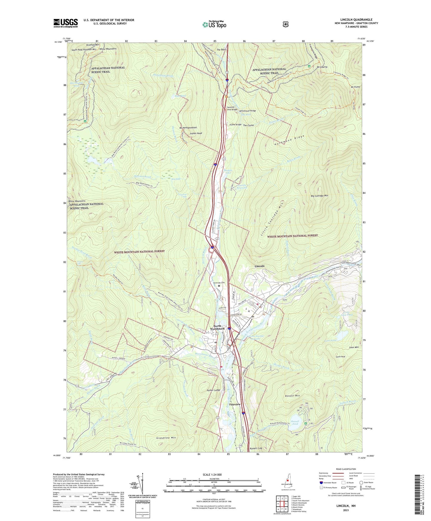
Lincoln New Hampshire US Topo Map
Couldn't load pickup availability
Also explore the Lincoln Forest Service Topo of this same quad for updated USFS data
2024 topographic map quadrangle Lincoln in the state of New Hampshire. Scale: 1:24000. Based on the newly updated USGS 7.5' US Topo map series, this map is in the following counties: Grafton. The map contains contour data, water features, and other items you are used to seeing on USGS maps, but also has updated roads and other features. This is the next generation of topographic maps. Printed on high-quality waterproof paper with UV fade-resistant inks.
Quads adjacent to this one:
West: Mount Moosilauke
Northwest: Sugar Hill
North: Franconia
Northeast: South Twin Mountain
East: Mount Osceola
Southeast: Waterville Valley
South: Woodstock
Southwest: Mount Kineo
This map covers the same area as the classic USGS quad with code o44071a6.
Contains the following named places: Basin Cascade Trail, Big Coolidge Mountain, Bog Eddy, Boles Brook, Boyce Brook, Boyle Brook, Campers World Campground, Cascade Brook, Church of the Messiah Episcopal Church, Crooked Brook, East Branch Pemigewasset River, Eliza Brook, Eliza Brook Shelter, Fairview, Fay State Forest, Fay Wayside, Flume Bridge, Flume Brook, Georgiana Falls, Gordon Falls, Gordon Pond Brook, Gordon Pond Trail, Grandview Mountain, Hanson Brook, Hardwood Ridge, Harrington Pond, Harvard Brook, Hobo Hill Adventure Golf, Horner Brook, Indian Head, Jackman Brook, Kinsman Ridge Trail, Liberty Spring Trail, Liberty Springs Campsite AMC, Lincoln, Lincoln Census Designated Place, Lincoln Center Shopping Center, Lincoln Fire Department, Lincoln Green Senior Housing, Lincoln Police Department, Lincoln Post Office, Lincoln Public Library, Lincoln Reservoir, Lincoln Sewage Lagoon Dikes, Lincoln Sewage Lagoons, Lincoln Square Mall Shopping Center, Lincoln Town Offices, Lincoln Woodstock Elementary School, Lincoln Woodstock High School, Lincoln Woodstock Middle School, Linwood Ambulance Service, Linwood Medical Center, Little Coolidge Mountain, Little Loon Pond, Loon Mountain, Loon Mountain Park, Loon Mountain Ski Area, Loon Mountain Winter Sports Area, Loon Pond, Loon Pond Brook, Loon Pond Dam, Lost River, Lost River Valley Campground, Moosilauke Brook, Mount Cilley Trail, Mount Flume, Mount Liberty, Mount Pemigewasset, Mount Pemigewasset Trail, Mud Pond, North Country Home Health Care Center, North Woodstock, North Woodstock Census Designated Place, North Woodstock Civilian Conservation Corps Camp, North Woodstock Post Office, North Woodstock Reservoir, Parker Ledge, Pike Brook, Pollard Brook, Riverside Cemetery, Russell Crag, Russell Farm, Russell Mountain, Russell Pond, Russell Pond Recreation Area, Saint Josephs Catholic Church, Saint Josephs Roman Catholic Church, Sentinel Pine Bridge, Shadow Lake, Shadow Lake Dam, Smith Brook, South Peak, South Peak Kinsman Mountain, The Basin, The Depot Retail Center Shopping Center, The Flume, The Mill at Loon Shopping Center, The Pool, The Village of Loon Mountain, Upper Pemi Historical Society Building, Walker Brook, White Mountain Motorsports Park, White Mountains Attractions Visitors Center, Whitehouse Bridge, Whitehouse Brook, Whitehouse Trail, Woodstock Fire Department, Woodstock Police Department