MyTopo
Gallup East New Mexico US Topo Map
Couldn't load pickup availability
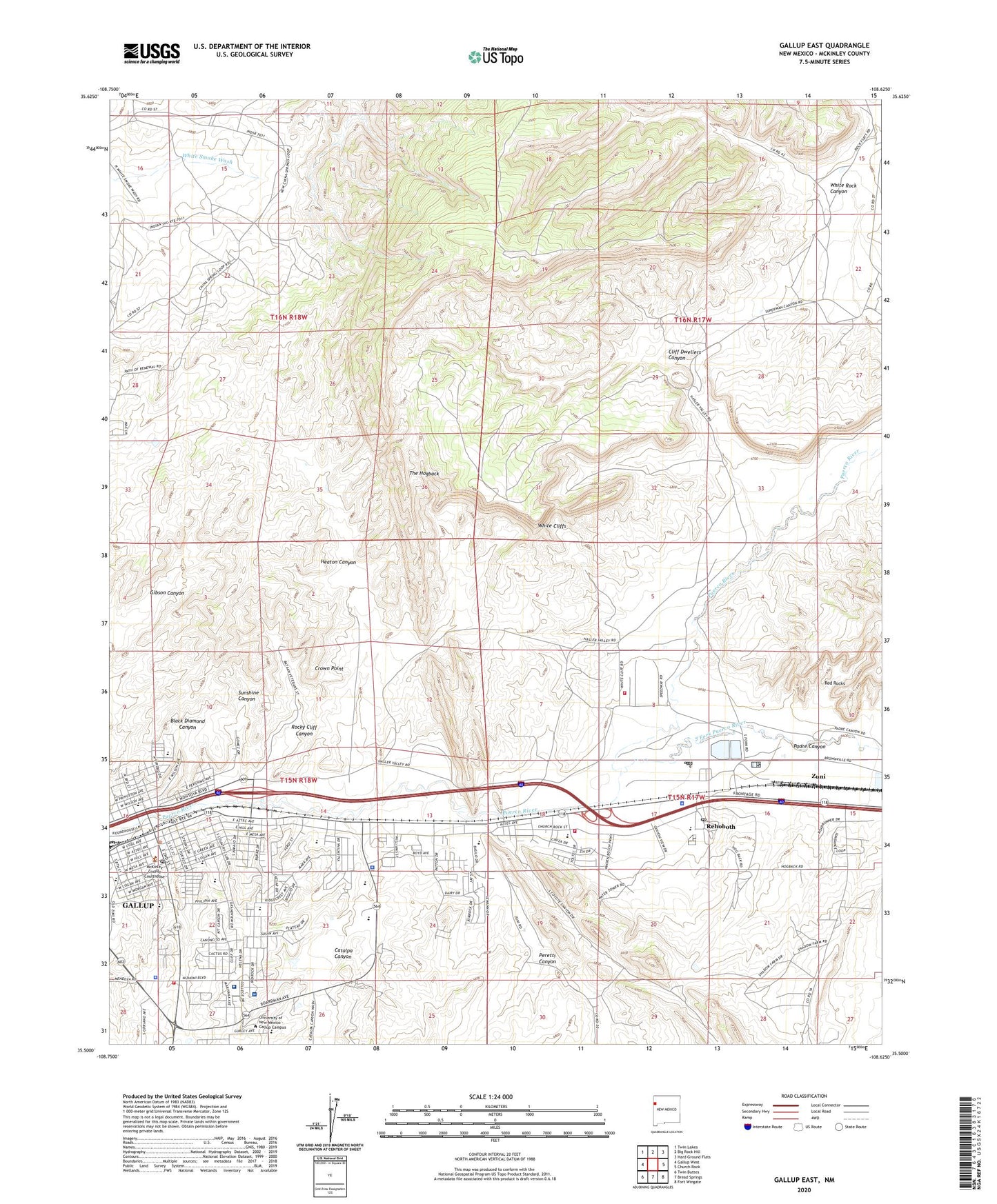
2023 topographic map quadrangle Gallup East in the state of New Mexico. Scale: 1:24000. Based on the newly updated USGS 7.5' US Topo map series, this map is in the following counties: McKinley. The map contains contour data, water features, and other items you are used to seeing on USGS maps, but also has updated roads and other features. This is the next generation of topographic maps. Printed on high-quality waterproof paper with UV fade-resistant inks.
Quads adjacent to this one:
West: Gallup West
Northwest: Twin Lakes
North: Big Rock Hill
Northeast: Hard Ground Flats
East: Church Rock
Southeast: Fort Wingate
South: Bread Springs
Southwest: Twin Buttes
This map covers the same area as the classic USGS quad with code o35108e6.
Contains the following named places: 10023 Water Well, 16K-303C Water Well, 87301, 87322, Atchison Topeka and Santa Fe Railway Depot Gallup Historic Site, Aztec Montessori School, Babe Ruth Park, Ba'hai Community of Gallup Church, Bethany Christian Reformed Church, Black Diamond Canyon, C N Cotton House, C N Cotton Warehouse Historic Site, Calvary Southern Baptist Church, Casa San Martin, Catalpa Canyon, Cathedral High School, Cathedral of the Sacred Heart, Catholic Diocese of Gallup Church, Catholic Indian Center, Central Junior High School, Chee Dodge Elementary School, Chiaramonte Mine, Church of the Holy Spirit, Church Rock Elementary School, City of Gallup, Cliff Dwellers Canyon, Crown Point, Dal Paso Center, Drake Hotel Historic Site, Educational Development Center, El Moro Theater Historic Site, El Rancho Hotel Historic Site, Elkins Pit, Emanuel Baptist Temple and Christian Academy, Enterprise Mine, Fellin Prospect, First Assembly of God Church, First Baptist Church, First Baptist Church Fellowship Center, First Indian Baptist Church, First United Methodist Church, Gallup, Gallup Baptist Church, Gallup Christian Center, Gallup Christian School, Gallup Church of Christ, Gallup Fire Department Station 1Main, Gallup Fire Department Station 3, Gallup Fire Department Station 5, Gallup Fuel Company Mine, Gallup High School, Gallup Historical Marker, Gallup Indian Medical Center, Gallup Indian Medical Center Library, Gallup Middle School, Gallup Police Department, Gallup Post Office, Gallup Weather Station, Gamerco Mine Smokestack Historic Site, Gibson, Gibson Mine, Gibson Post Office, Golino Mine, Good News Parish, Grand Hotel Historic Site, Grand Mission Mine, Grenko Mine, Harrison House Historic Site, Harvey Hotel Historic Site, Heaton, Heaton Canyon, Heaton Mine, Hillside Mine, Hyde Mine, Indian Assembly of God Church, Indian Hills Elementary School, J and P Mine, Jefferson School, John F Kennedy Middle School, Juan De Onate Elementary School, Juliano Mine, Kauzlarich Mine, Keepers Mine, KGAK-AM (Gallup), KGLX-FM (Gallup), KKJI-FM (Gallup), KOAV-TV (Gallup), KQNM-FM (Gallup), KXTC-FM (Thoreau), KYVA-AM (Gallup), Lebanon Lodge Number 22 Historic Site, Lincoln Elementary School, Lincoln School, McKinley County Courthouse Historic Site, McKinley County Sheriff's Office Gallup, Med Star Ambulance, Mentmore Meadows Historic Site, Morelli Mine, Myers Mine, Nance Mine, New Mexico State Police District 6 Gallup, New Mutual Mine, New Otero Mine, Octavia Fellen Public Library, Padre Canyon, Palace Hotel Historic Site, Parron Mine, Peacock Number Two Mine, Peacock Numbers 2 3 and 4 Mines, Pentecostal Church of God Navajo Mission, Peretti Canyon, Pinedale Indian Assebly of God Church, Pinon Placita Shopping Center, Red Rock Elementary School, Rehoboth, Rehoboth Christian Elementary School, Rehoboth Christian High School, Rehoboth McKinley Christian Health Care Services Hospital, Rehoboth McKinley Christian Health Care Services Inc Library, Rehoboth McKinley Christian Health Care Services Incorporated, Rehoboth McKinley Christian Hospital Library, Rehoboth Post Office, Rex Hotel Historic Site, Roberts Coal Mine, Rocky Cliff Canyon, Roosevelt Elementary School, Roosevelt School, Sacred Heart Cathedral Elementary and Middle School, Saint Francis of Assisi Church, Saint Francis of Assisi School, Saint Francis School, Saint Jeromes Church, Saint John Vianney Parish, Saint Valerian Catholic Church, Saint William Church, Seventh Day Adventist Church, Sky City School, South Fork Puerco River, Spanish Assembly of God Church, Spanish Baptist Church, Stagecoach Elementary School, Sundance Census Designated Place, Sunnyside School, Sunshine Canyon, Thacther Mine, Thatcher Mine, The Church of Jesus Christ of Latter Day Saints - Gallup Stake, Trinity Lutheran Church, Twin Buttes Church of the Nazarene, Twin Buttes High School, Twin Lakes Elementary School, United Pentecostal Church, University of New Mexcio - Gallup Campus Zollinger Library, University of New Mexico Gallup Branch, University of New Mexico-Gallup Campus Zollinger Library, Washington Elementary School, Weaver, Weaver Mine, West Mesa Assembly of God Church, Westminister United Presbyterian Church, Westminster Presbyterian Church, White Cafe, White Cliffs, White Cliffs Census Designated Place, White Cliffs Volunteer Fire Department, White Rock Canyon, Wildcat Christian Academy, William Coal Company Mine, Wilson School, Zuni, Zuni High School, Zuni Middle School