MyTopo
Kingston New Mexico US Topo Map
Couldn't load pickup availability
Also explore the Kingston Forest Service Topo of this same quad for updated USFS data
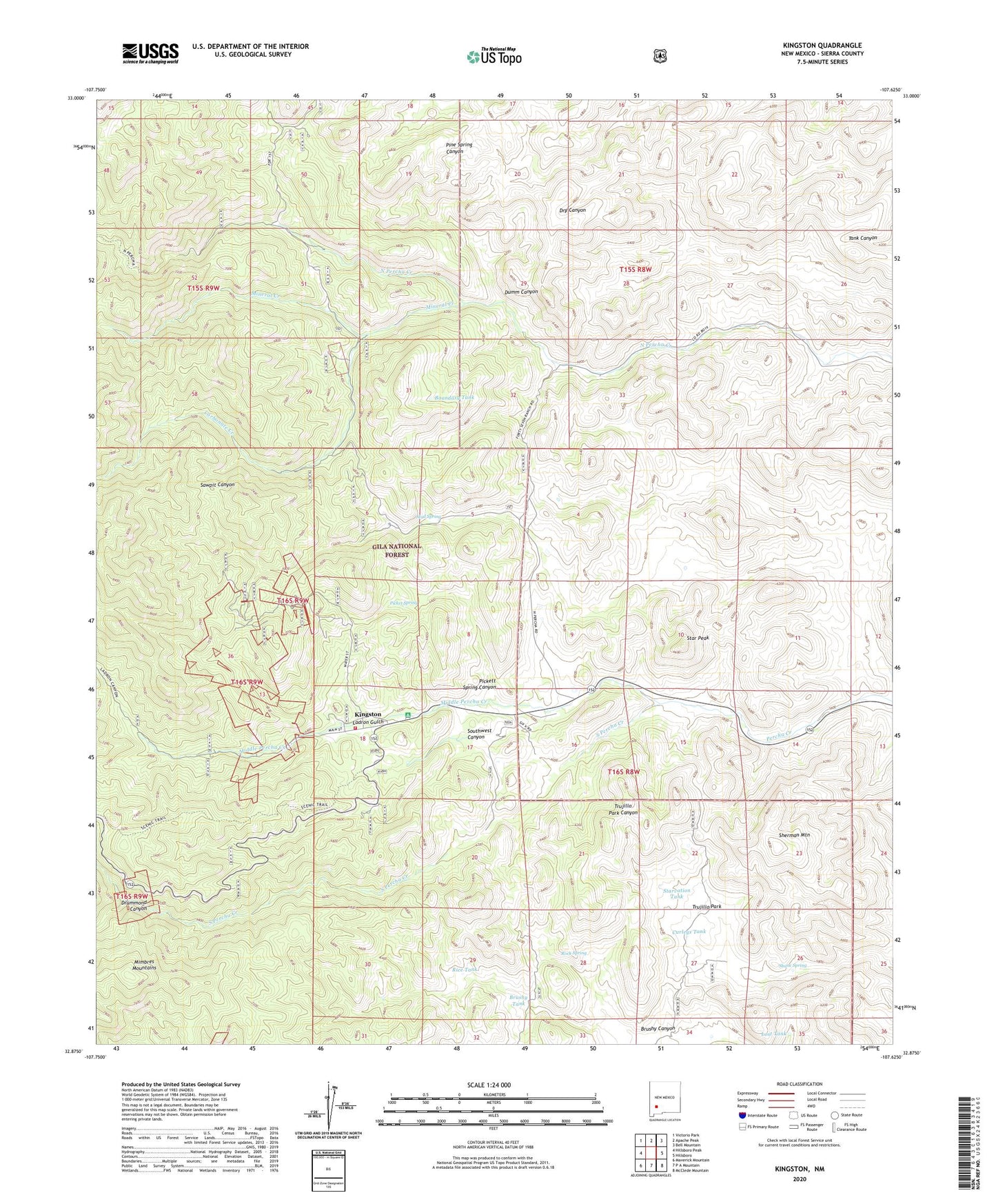
2023 topographic map quadrangle Kingston in the state of New Mexico. Scale: 1:24000. Based on the newly updated USGS 7.5' US Topo map series, this map is in the following counties: Sierra. The map contains contour data, water features, and other items you are used to seeing on USGS maps, but also has updated roads and other features. This is the next generation of topographic maps. Printed on high-quality waterproof paper with UV fade-resistant inks.
Quads adjacent to this one:
West: Hillsboro Peak
Northwest: Victorio Park
North: Apache Peak
Northeast: Bell Mountain
East: Hillsboro
Southeast: McClede Mountain
South: P A Mountain
Southwest: Maverick Mountain
This map covers the same area as the classic USGS quad with code o32107h6.
Contains the following named places: Andy Johnson and Brush Heap Mine, Andy Johnson Mine, Barite Hill Number 1, Basin and Cox Ranch, Basin Tank, Black Colt Claim - North Kingston, Black Colt Mine, Black Magic Mine, Black Sheep Group Mine, Black Sheep-North Kingston D Mine, Blackeyed Susan Mine, Blackie Number 1 Mine, Blackie Number One Mine, Bloodgood A and B Group, Bloodgood Mine, Boundary Tank, Brush Heap Mine, Brushy Canyon, Brushy Tank, Calamity Jane Mine, Caledonia Mine, Carbonate Creek, Climax Mine, Comstock Claim, Comstock Mine, Cruise Shaft, Curleys Tank, Dove Mine, Drummond Canyon, Dumm Canyon, Enterprise Mine, Fabian MIne, General Jackson Mine, Gray Eagle, Gray Eagle Mine, Gypsy IV Group, Gypsy Mine, Hillsboro Volunteer Fire Department - Kingston Substation, Illinois Mine, Iron King Mine, Kangaroo Mine, Kingston, Kingston Campground, Kingston Cemetery, Kingston Census Designated Place, Kingston Post Office, Kingston Ranger Station, Ladron Gulch, Lady Franklin Mine, Lost Tank, Matchless Mine, Middle Percha Creek, Mineral Creek, Miners Dream, Mud Spring, New York Group, O K Mine, Percha Bank Historic Site, Petaluma, Picket Spring, Picket Springs Mine, Pickett Spring Canyon, Pride of the Camp and Blackeye Mine, Rice Tank, Rock Spring, Sally B Number One Mine, Samoa 992-B Mine, Sawpit Canyon, Shane Spring, Sherman Mountain, Sherman Tank, Silver King Mine, Silver Queen, So Mine Number One, South Percha Creek, Southwest Canyon, Star Peak, Starvation Tank, Stowe Mine, Superior Mine, Superior-North Kingston District, Tall Pine Claim-N. Kinston D, Tall Pine Mine, TR Ranch, Trujillo Park, United States and Illinois, United States Mine, Victoria Mine, Viola Mine, Virginia, Wagon Wheel and Prospect, Wagon Wheel and Prospect Group, Yorin-Superior Tunnel