MyTopo
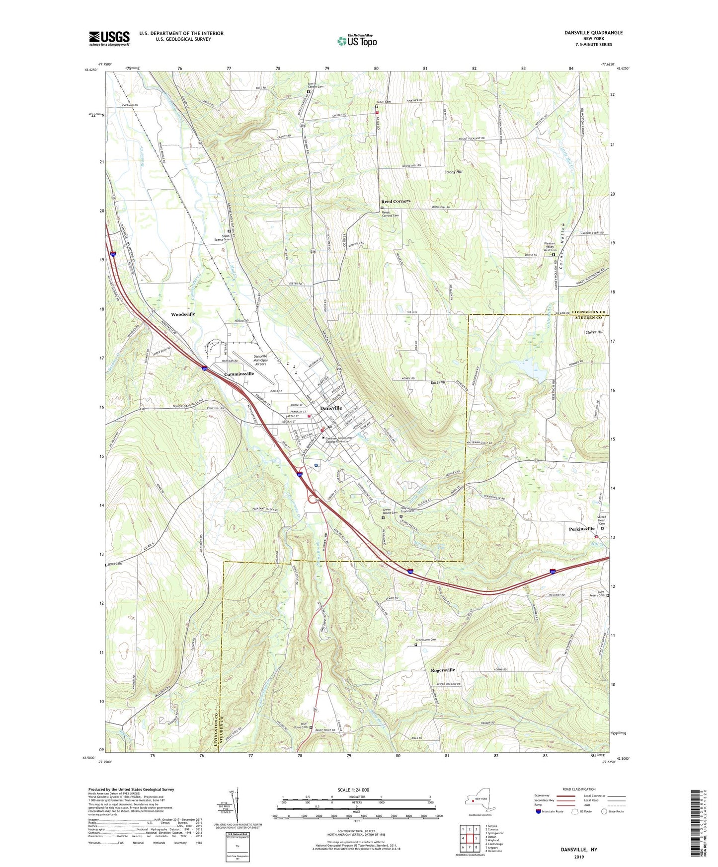
Dansville New York US Topo Map
Couldn't load pickup availability
2023 topographic map quadrangle Dansville in the state of New York. Scale: 1:24000. Based on the newly updated USGS 7.5' US Topo map series, this map is in the following counties: Livingston, Steuben. The map contains contour data, water features, and other items you are used to seeing on USGS maps, but also has updated roads and other features. This is the next generation of topographic maps. Printed on high-quality waterproof paper with UV fade-resistant inks.
Quads adjacent to this one:
West: Ossian
Northwest: Sonyea
North: Conesus
Northeast: Springwater
East: Wayland
Southeast: Haskinville
South: Arkport
Southwest: Canaseraga
This map covers the same area as the classic USGS quad with code o42077e6.
Contains the following named places: Alexanders Tree Farm, Assembly of God Church, Bluff Point Cemetery, Brae Burn Golf Course, Carney Hollow, Cumminsville, Cumminsville Census Designated Place, Dansville, Dansville Ambulance Company, Dansville City Hall, Dansville Fearless Hook and Ladder Fire Department, Dansville Fire Department, Dansville Memorial Hospital, Dansville Middle School, Dansville Municipal Airport, Dansville Post Office, Dansville Presbyterian Church, Dansville Primary School, Dansville Public Library, Dansville Public School, Dansville Reservoir, Dansville Revival Tabernacle, Dansville Senior High School, Dansville Station, Dansville Wastewater Treatment Plant, Dutch Cemetery, East Hill, Ellis B Hyde Elementary School, Elm Park, First Methodist Church, Free Methodist Church, Grace Baptist Church, Green Mount Cemetery, Greenlawn Cemetery, Grunmount Court Mobile Home Park, Holy Cross Cemetery, Holy Family School, James Jackson Hose Company Number 2, Kingdom Hall of Jehovah's Witnesses, King's Daughters' and Sons Home Assisted Living Center, Little Mill Creek, Marks Trailer Park, Mill Creek, Mud Creek, New Apostolic Church, North Dansville Town Hall, Noyes Memorial Hospital, Patterson Gully, Perkinsville, Perkinsville Fire Department, Perkinsville Post Office, Pleasant Valley Church, Pleasant Valley West Cemetery, Poags Hale Mobile Home Court, Pokamoonshine Hollow, Reed Corners, Reeds Corners Cemetery, Rogersville, Rolling Hills Mobile Home Park, Rotary Park, Sacred Heart Cemetery, Saint Mary's Roman Catholic Church, Saint Patrick's Parochial School, Saint Patrick's Roman Catholic Church, Saint Paul's United Lutheran Church, Saint Peters Cemetery, Saint Peter's Episcopal Church, School Number 1, School Number 2, School Number 3, School Number 5, School Number 9, South Sparta Cemetery, Sparta Center Cemetery, Sparta Center United Methodist Church, Sparta Center Volunteer Fire Company, Sponable Gully, Star Theatre, Stone Falls, Stony Brook, Stony Brook Glen, Stony Brook State Park, Strong Hill, Town of North Dansville, Union Hose Company Number 1, Village of Dansville, WACZ-FM (Dansville), Washington Park, WDNY-AM (Dansville), West Sparta Station, White Bridge, Whiteman Gully, Woodsville, Woodsville Census Designated Place, Wright Church, ZIP Codes: 14437, 14529