MyTopo
Hornell New York US Topo Map
Couldn't load pickup availability
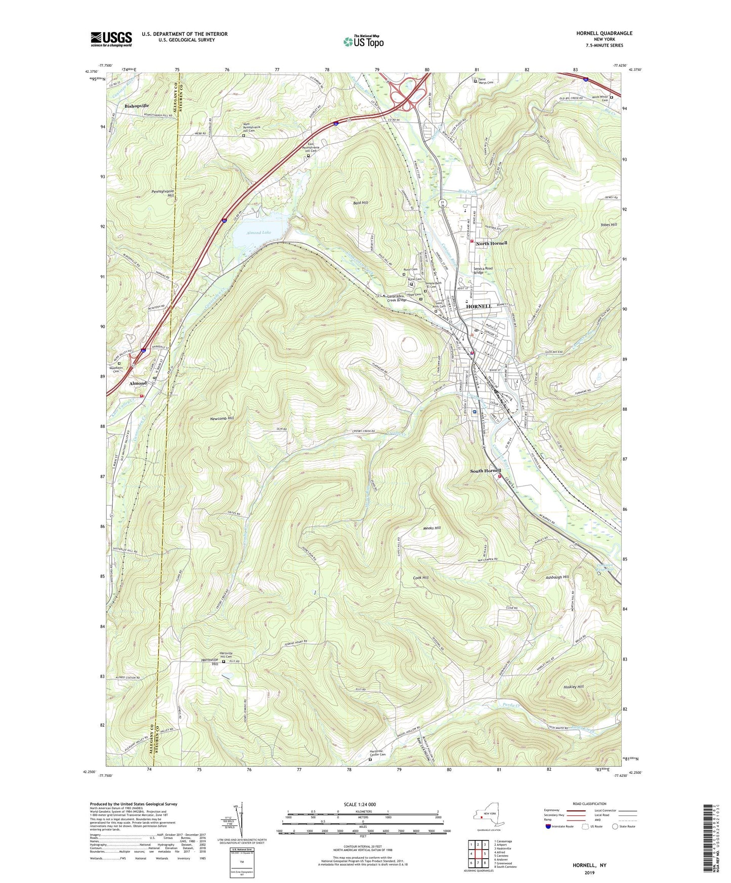
2023 topographic map quadrangle Hornell in the state of New York. Scale: 1:24000. Based on the newly updated USGS 7.5' US Topo map series, this map is in the following counties: Steuben, Allegany. The map contains contour data, water features, and other items you are used to seeing on USGS maps, but also has updated roads and other features. This is the next generation of topographic maps. Printed on high-quality waterproof paper with UV fade-resistant inks.
Quads adjacent to this one:
West: Alfred
Northwest: Canaseraga
North: Arkport
Northeast: Haskinville
East: Canisteo
Southeast: South Canisteo
South: Greenwood
Southwest: Andover
This map covers the same area as the classic USGS quad with code o42077c6.
Contains the following named places: Abundant Life Ministries, Almond, Almond Lake, Almond Post Office, Almond Town Hall, Almond Volunteer Fire Company and Ambulance, Amos White Cemetery, Ashbaugh Hill, Bald Hill, Bear Lick Hollow, Bethesda Community Hospital, Bethesda Hospital, Big Creek, Bishopville, Bryant School, Canacadea Creek, Canacadea Creek Bridge, Canisteo Reservoir, Chauncey Run, Christ Episcopal Church, Christian and Missionary Alliance Church, City of Hornell, Columbian School, Cook Hill, Crosby Creek, Crosby School, East Avenue Methodist Church, East Pennsylvania Hill Cemetery, Edgewood School, Eells School, Erie Building, First Church of Christ Scientist, First Universalist Church, Free Methodist Church, Gladtidings Assembly of God Church, Grange Creek, Green Acres Mobile Home Park, Hartsville Center Cemetery, Hartsville Church, Hartsville Hill, Hartsville Hill Cemetery, Hillside Baptist Church, Hinkley Hill, Honey Run, Hope Cemetery, Hornell, Hornell Armory, Hornell Bible Church, Hornell Children's Home, Hornell City Ambulance Service, Hornell City Hall, Hornell City Wastewater Pollution Control Point, Hornell Country Club, Hornell Fire Department, Hornell First Baptist Church, Hornell Gardens, Hornell Intermediate School, Hornell Junior High School, Hornell Mobile Home Park - Edgeview Estates, Hornell Post Office, Hornell Public Library, Hornell Senior High School, Karr Valley Creek, Lincoln School, Majestic Theatre, Maple City Park, Marsh Ditch, McAuley Manor at Mercycare, Meeks Hill, Meeks School, Newcomb Hill, North Hornell, North Hornell School, North Hornell Village Hall, North Hornell Volunteer Fire Company, Park Methodist Church, Pennsylvania Hill, Rehoboth Deliverance Ministries, Rural Cemetery, Saint Anns Cemetery, Saint Ann's Convent of Mercy, Saint Ann's Parochial School, Saint Ann's Roman Catholic Church, Saint Brendans Church, Saint Ignatius Loyola Roman Catholic Church, Saint James Mercy Hospital, Saint Marys Cemetery, Saint Paul's Evangelical Lutheran Church, Saint Paul's United Church of Christ, Seeley Creek, Seneca Road Bridge, South Hornell, South Hornell Fire Company, Southside Baptist Church, Spencer Methodist Church, Starlite Drive-In, Temple Beth - El, Temple Beth - El Cemetery, The Church of Jesus Christ of Latter Day Saints, Tobes Hill, Town of Hornellsville, Twentieth Century Club Library, Twin Hickory Golf Club, Union Park, United Presbyterian Church, Updyke's Willow Ridge Quality Care Facility, Village of Almond, Village of North Hornell, Washington School, WCKR-FM (Hornell), Webbs Crossing, West Pennsylvania Hill Cemetery, Westminster Presbyterian Church, WHHO-AM (Hornell), WKPQ-FM (Hornell), WLEA-AM (Hornell), Woodlawn Cemetery, ZIP Codes: 14803, 14843