MyTopo
Asheville North Carolina US Topo Map
Couldn't load pickup availability
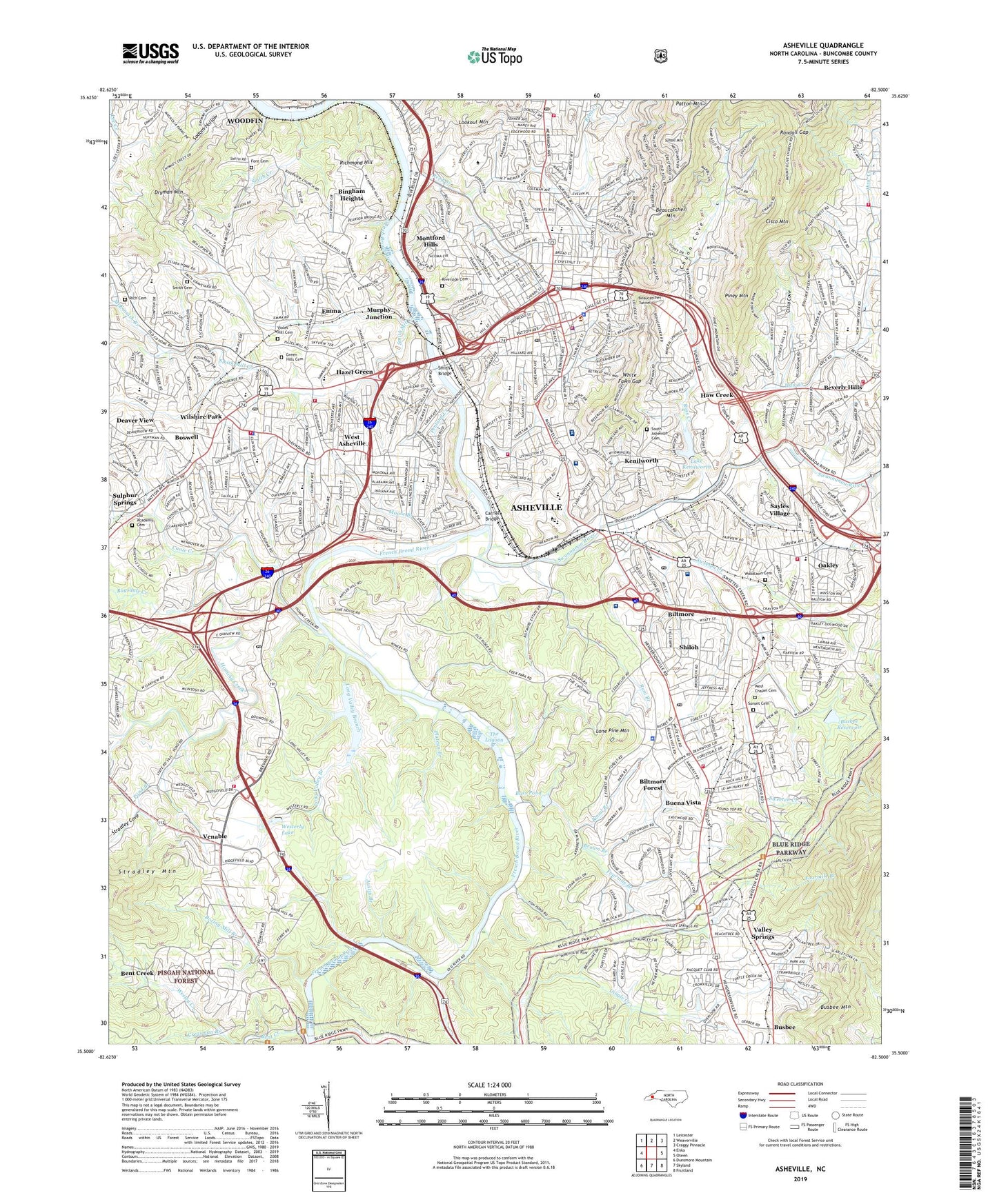
2019 topographic map quadrangle Asheville in the state of North Carolina. Scale: 1:24000. Based on the newly updated USGS 7.5' US Topo map series, this map is in the following counties: Buncombe. The map contains contour data, water features, and other items you are used to seeing on USGS maps, but also has updated roads and other features. This is the next generation of topographic maps. Printed on high-quality waterproof paper with UV fade-resistant inks.
Quads adjacent to this one:
West: Enka
Northwest: Leicester
North: Weaverville
Northeast: Craggy Pinnacle
East: Oteen
Southeast: Fruitland
South: Skyland
Southwest: Dunsmore Mountain
Contains the following named places: AB Tech College, Albemarle, Antioch Church, Appalachian Hall Hospital, Arden Plaza, Asheville, Asheville Airpark, Asheville Biltmore College, Asheville Country Day School, Asheville Fire and Rescue Station 1, Asheville Fire and Rescue Station 11, Asheville Fire and Rescue Station 2, Asheville Fire and Rescue Station 3, Asheville Fire Department Station 12, Asheville Fire Department Station 5, Asheville Fire Department Station 6, Asheville Fire Department Station 7, Asheville Fire Department Station 8, Asheville Fire Department Station 9, Asheville Mall, Asheville Police Department, Asheville Police Department Adam District West Office, Asheville Post Office, Asheville School for Boys, Asheville Specialty Hospital, Asheville Surgery Center, Asheville-Buncombe Technical Community College, Aston Park, Aston Park Hospital, Austin Branch, Aycock School, Bacoate Branch, Bass Pond, Beaucatcher Mountain, Beaucatcher Tunnel, Ben Lippen School, Bent Creek, Bent Creek Census Designated Place, Bent Creek Church, Bent Creek Experimental Station, Bent Creek Ranch Lake, Bethany Church, Bethel Church, Bethesda Church, Beverly Hills, Biltmore, Biltmore Forest, Biltmore Forest Center, Biltmore Forest Country Club, Biltmore Forest Police Department, Biltmore House, Biltmore Post Office, Biltmore Square, Bingham Heights, Boring Mill Branch, Boswell, Broadview, Brooklawn Park, Brooklyn Church, Brown Branch, Buena Vista, Buncombe County, Buncombe County Courthouse, Buncombe County Detention Facility, Buncombe County Emergency Medical Services, Buncombe County Home, Buncombe County Rescue Squad - Ambulance, Buncombe County Sheriff's Office, Busbee Reservoir, Buttermilk Creek, Camelot, Canie Creek, CarePartners Rehabilitation Hospital, Carmel Monastery, Carrier Bridge, Chunn Cove, Cisco Cove, Cisco Mountain, City of Asheville, Claxton School, Country Club of Asheville, Craggy Prison, Creasman Branch, Deaver View, Dellwood Lake, Dingle Creek, Dogwood Grove, Downtown Asheville Post Office, Dryman Mountain, East Biltmore, Eastvale Shopping Center, Echo Hills, Eliada Home for Children, Eliada Plaza, Emma, Emma Census Designated Place, Emma Elementary School, Eugene Rankin School, Fairview, Fore - Rutledge Cemetery, Fourmile Branch, Fox Creek, Gashes Creek, Gibson Creek, Gordon Branch, Grace Post Office, Great Smokies Hilton, Green Hills Cemetery, Grove Park, Haith Branch, Hall Fletcher School, Happy Valley, Haw Creek, Hawthorne, Hazel Green, Highland Gate, Highland Hospital, Hill Street School, Hillcrest Apts, Hominy Creek, Innsbruck Mall, Johnston School, Kenilworth, Knollwood, Lake Ashnoca, Lake Ashnoca Dam, Lake Kenilworth, Lake Kenilworth Dam, Lee Edwards School, Lee Walker Hots, Linwood Park, London Road Annex Post Office, Lone Pine Mountain, Long Valley Branch, Long Valley Lake, Lookout Mountain, Lucy B Herring Elementary School, Malvern Hills, Malvern Hills Park, McKinnish Branch, Memorial Stadium, Mission Children's Hospital, Mission Hospital, Mission Hospital - Saint Joseph Campus, Montford Hills, Montford Park, Moore Branch, Mountainbrook, Municipal Golf Course, Murphy Junction, Murry Hill Park, Newton School, North Carolina State Highway Patrol Troop G District 4, North Carolina State Highway Patrol Troop G Headquarters District 4, Norwood Park, Oakley, Oakley Elementary School, Old Academy Cemetery, Orchard Creek, Parkway Plaza, Patton Avenue Park, Patton Mountain, Penland Creek, Piney Mountain, Pisgah View, Plateau Branch, Pond Branch, Ragsdale Creek, Ram Branch, Randall Gap, Randolph School, Redwood Village, Reed Creek, Rhododendron Creek, Rhododendron Park, Rich Cemetery, Richmond Hill, Richmond Hill Park, River Ridge Market Place, Riverside Cemetery, Rolling Green, Rooul Branch, Rosebank Park, Ross Creek, Saint Joseph Hospital, Sayles Village, Shiloh, Smith Bridge, Smith Cemetery, Smith Creek, Smith Mill Creek, South Asheville Cemetery, Spring Time, Stephens Lee High School, Stockwood, Stradley Cove, Sulphur Springs, Sunset Cemetery, Sunset Mountain, Swannanoa River, Sweeten Creek, The Lagoon, Town and Country Shopping Center, Town of Biltmore Forest, Turtle Creek Shopping Center, University of North Carolina - Botanical Gardens, University of North Carolina at Asheville, Valley Springs, Vance School, Venable, Venable Community, Venable Elementary School, Violet Hill Cemetery, Walton Street Park, Weaver Park, West Asheville, West Asheville Post Office, West Chapel Cemetery, Westerly Lake, Westgate Regional Shopping Center, Westside Community Park, White Fawn Gap, White Fawn Reservoir, WHNS-TV (Asheville), Wilshire Park, WISE-AM (Asheville), Woodlawn Cemetery, Woolsey, WRAQ-AM (Asheville), WSKY-AM (Asheville), WUNF-FM (Asheville), WWNC-AM (Asheville), ZIP Codes: 28801, 28803, 28806