MyTopo
Weaverville North Carolina US Topo Map
Couldn't load pickup availability
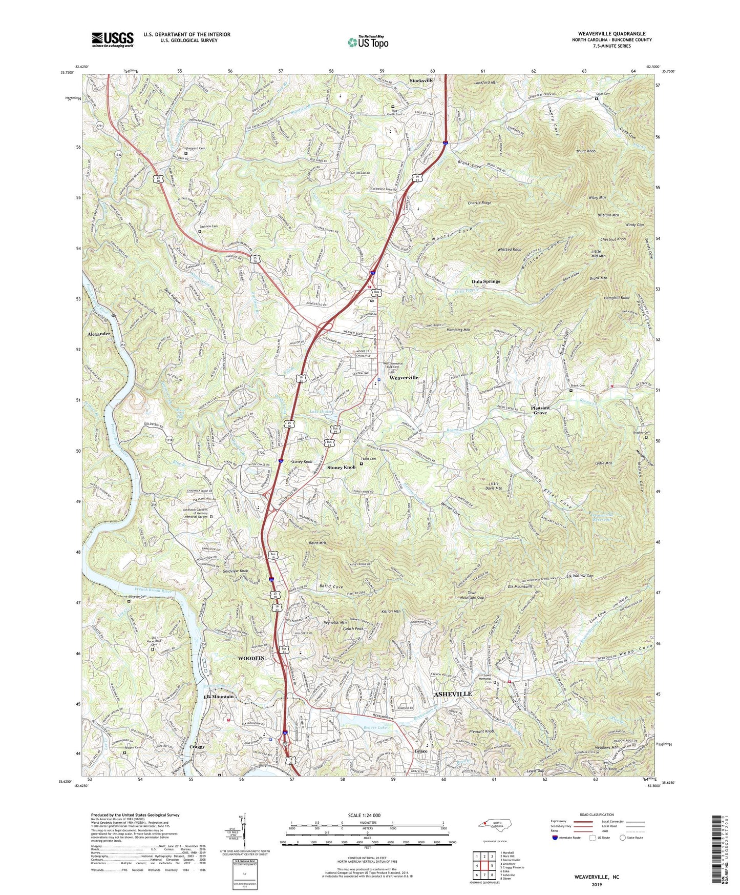
2022 topographic map quadrangle Weaverville in the state of North Carolina. Scale: 1:24000. Based on the newly updated USGS 7.5' US Topo map series, this map is in the following counties: Buncombe. The map contains contour data, water features, and other items you are used to seeing on USGS maps, but also has updated roads and other features. This is the next generation of topographic maps. Printed on high-quality waterproof paper with UV fade-resistant inks.
Quads adjacent to this one:
West: Leicester
Northwest: Marshall
North: Mars Hill
Northeast: Barnardsville
East: Craggy Pinnacle
Southeast: Oteen
South: Asheville
Southwest: Enka
This map covers the same area as the classic USGS quad with code o35082f5.
Contains the following named places: Alexander, Alexander Chapel, Alexander Post Office, Asbury Memorial Church, Ashelawn Gardens of Memory Memorial Garden, Asheville-Weaverville Speedway, Baird Cove, Baird Mountain, Beaver Lake, Beaver Lake Dam, Beaver Lake Golf Course, Beaverdam Church, Beaverdam Creek, Beaverdam Volunteer Fire Department, Belew Hollow, Blue Branch, Boyds Union Chapel, Bradley Cemetery, Brank Cemetery, Brank Cove, Brank Mountain, Brittain Cove, Brittain Cove Church, Brittain Mountain, Carter Cove, Charlie Ridge, Chestnut Knob, Clarks Chapel, Coles Cemetery, Coles Cove, Coles Cove Church, Craggy, Craggy Correctional Center, Craggy Dam, Craggy Dam Reservoir, Dark Hollow, Davis - Capps Cemetery, Dick Branch, Dula Springs, Elk Mountain, Elk Mountains, Elk Wallow Gap, Eller Cove, Flat Creek Cemetery, Flat Creek Church, Garrison Branch, Garrison Cemetery, Gill Branch, Goldview Knob, Gouch Peak, Grace, Grace Plaza, Hamburg Mountain, Hemphill Knob, Herron Cove, Herron Cove Branch, Indian Camp Branch, Ira B Jones School, Jenkins Branch, Jones View Church, Killian Mountain, Lake Louise, Lake View Park, Lankford Mountain, Lee Creek, Lewis Gap, Lewis Memorial Cemetery, Linn Cove, Little Davis Mountain, Little Flat Creek, Little Middle Mountain, Little Mount Zion Church, Long Chapel, Lowery Cove, Lydie Mountain, Maple Springs Church, Meadows Mountain, Mount Bethel Church, Mount Sheba Church, Munday Cove, Mundy Cove, New Hope Church, New Liberty Church, North Buncombe High School, Northland Shopping Center, Old Macedonia Cemetery, Olivette Cemetery, Ox Creek, Pine Burr Park Church, Pink Fox Cove, Pleasant Grove, Pleasant Grove Church, Pleasant Hill Church, Pleasant Knob, Rays Chapel, Reems Creek, Reems Creek Church, Reems Creek Falls, Reems Creek Fire Department, Reynolds Mountain, Rhodes Cemetery, Rice Branch, Rich Knob, Salem Church, Sheppard Branch, Sheppard Cemetery, Sodom Hollow, Spooks Branch, Stanfield Branch, Stocksville, Stoney Knob, Thurz Knob, Town Mountain Gap, Town of Weaverville, Town of Woodfin, Township of Asheville, Township of Reems Creek, Union Chapel, Vance Homestead, Victory Church, Wagner Branch, Weaversville Fire Department, Weaverville, Weaverville Police Department, Weaverville Post Office, Weaverville Primary School, Weaverville Reservoir, Webb Cove, West Buncombe School, West Memorial Park Cemetery, White Branch, Whitted Knob, Whittington Branch, Wiley Mountain, Windy Gap, Wolf Cove, Woodfin, Woodfin Elementary School, Woodfin Reservoir, Woodfin Volunteer Fire Department, Wooten Cove, ZIP Codes: 28787, 28804