MyTopo
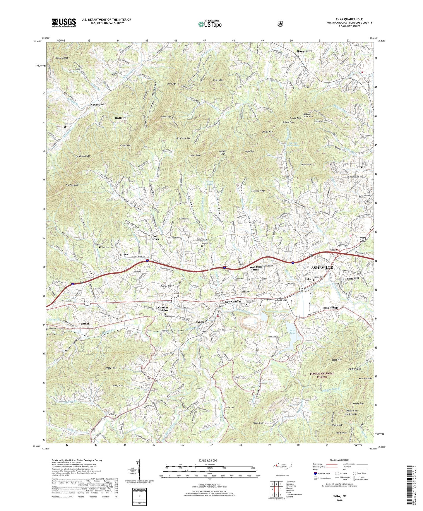
Enka North Carolina US Topo Map
Couldn't load pickup availability
Also explore the Enka Forest Service Topo of this same quad for updated USFS data
2022 topographic map quadrangle Enka in the state of North Carolina. Scale: 1:24000. Based on the newly updated USGS 7.5' US Topo map series, this map is in the following counties: Buncombe. The map contains contour data, water features, and other items you are used to seeing on USGS maps, but also has updated roads and other features. This is the next generation of topographic maps. Printed on high-quality waterproof paper with UV fade-resistant inks.
Quads adjacent to this one:
West: Canton
Northwest: Sandymush
North: Leicester
Northeast: Weaverville
East: Asheville
Southeast: Skyland
South: Dunsmore Mountain
Southwest: Cruso
This map covers the same area as the classic USGS quad with code o35082e6.
Contains the following named places: Acton, Asheville Fire and Rescue Station 10, Baldwin Field Branch, Baldwin Gap, Beaverdam Creek, Beaverdam Wildlife Restoration Area, Bert Mountain, Big Cove, Bill Moore Creek, Brooks Branch, Brooks Cemetery, Brooks Cove, Bryson Branch, Candler, Candler Heights, Candler Post Office, Candler School, Case Cove, Cedar Hill Baptist Church Cemetery, Clyde A Erwin High School, Cole Cemetery, Corinth Church, Cowan Cove, Curtis Creek, Deaver View Mountain, Dix Creek Chapel, Dix Creek Gap, Edgewood Church, Enka, Enka Candler Fire and Rescue, Enka High School, Enka Lake, Enka Lake Dam, Enka Post Office, Enka Quarry, Enka Village, Erwin Hills Shopping Center, Forest Lawn Memorial Park, Francis Ashbury Church, George Branch, Georgetown, Glady, Grace Chapel, Happy Valley Church, Harkins Cemetery, Hayes Cove, Hayes Top, Herren Cove, Hice Hill Cemetery, High Point, High Top, Holcombe Cove, Hominy, Hominy Church, Hooker Gap, J and J Fishing Lake, J and J Trout Lake, Jugtown, Justice Cemetery, Justice Ridge, Liberty Church, Little Pole Creek, Luther, Luther Cemetery, Luther Cove, Luther Gap, Luther Knob, Mease Gap, Milksick Cove, Miller Mountain, Montmorenci Church, Moore Creek, Moors Gap, Morgan Branch, Morgan Cove, Mount Moriah Church, Mount Pisgah Academy, Mount View Church, New Candler, New Morgan Hill Church, Newfound, Oak Forest Church, Oak Hill Church, Owltown, Peggy Peak, Piney Mountain, Piney Mountain Church, Pisgah School, Pisgah View Church, Pisgah View Memorial Park, Pleasant Hill Church, Pole Creek, Pole Creek Church, Potato Gap, Potato Knob, Reeves Chapel, Rice Pinnacle, Ridgeway Cemetery, Ridgeway Church, Samuel Bell Gudger Cemetery, Sand Hill, Sand Hill Middle School, Sand Hill Primary School, Scott Mountain, Sheep Gap, Snow Hill Church, South Hominy Creek, Spivey Gap, Spivey Mountain, Starnes Cove, Starnes Cove Church, Starnes Cove Fishing Lake Dam, Starnes Cove Lakes, Starnes Ridge, Sunrise Church, The Pinnacle, Thrash Dam, Thrash Lake, Township of Lower Hominy, Township of Upper Hominy, Trull Cemetery, WBMU-FM (Asheville), Webb Branch, West Buncombe Volunteer Fire and Rescue, White Rock Church, Wise Branch, Wise Knob, Wolf Knob, Woodland Terrace Church, Woodside Hills, Young Branch, Young Cove, Zion Hill Church, ZIP Code: 28715