MyTopo
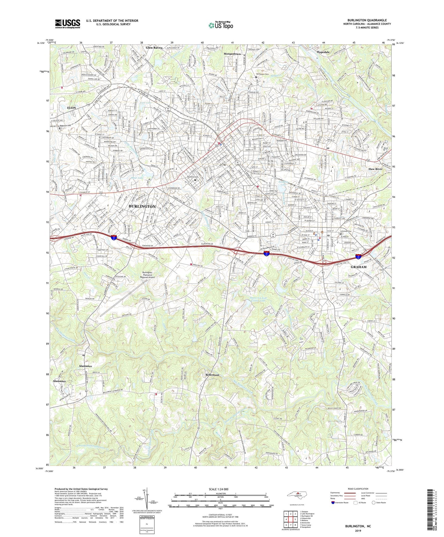
Burlington North Carolina US Topo Map
Couldn't load pickup availability
2023 topographic map quadrangle Burlington in the state of North Carolina. Scale: 1:24000. Based on the newly updated USGS 7.5' US Topo map series, this map is in the following counties: Alamance. The map contains contour data, water features, and other items you are used to seeing on USGS maps, but also has updated roads and other features. This is the next generation of topographic maps. Printed on high-quality waterproof paper with UV fade-resistant inks.
Quads adjacent to this one:
West: Gibsonville
Northwest: Ossipee
North: Lake Burlington
Northeast: Burlington NE
East: Mebane
Southeast: Saxapahaw
South: Snow Camp
Southwest: Kimesville
This map covers the same area as the classic USGS quad with code o36079a4.
Contains the following named places: Alamance, Alamance Acres, Alamance County, Alamance County Emergency Medical Services, Alamance County Rescue Unit, Alamance County Sheriff's Office, Alamance Industrial Park, Alamance Post Office, Avalon Valley, Back Creek, Bellemont, Bethany Church, Beverly Hills, Blessed Sacrament School, Bowden Branch, Boyds Creek, Broad Acres, Broadview Junior High School, Burlington, Burlington Fire Department Headquarters, Burlington Fire Department Station 3, Burlington Fire Department Station 4, Burlington Fire Department Station 5, Burlington Fire Station No. 2, Burlington Fire Training Center, Burlington Police Department, Burlington Post Office, Burlington Square Mall, Burlington-Alamance Regional Airport, Cedar Crest, Central Heights, Christ Church, City of Burlington, City of Graham, Country Club Estates, Country Club Forest, Crestwood, Cummings High School, Cum-Park Plaza, Dogwood Acres, E M Holt Fire Department, Eastlawn School, Edgewood Church, Edgewood Village Shopping Center, Elmira School, Elon Fire Department Station 18, Fairchild Park, Faith Church, Fellowship Church, Fisher Street School, Forest Hill School, Forest Hills, Gant Lake, Glen Raven, Glen Raven Census Designated Place, Glen Raven Shopping Center, Graber Heights, Graham, Graham Fire Department, Graham High School, Graham Middle School, Graham Municipal Park, Graham Police Department, Graham Post Office, Greenbrier, Greenway Park Church, Grove Park, Grove Park School, Gum Creek, Gunn School, Harvey R Newlin Elementary School, Hillcrest Avenue School, Holt School, Hopedale, Hunting Hills, Jackson Park, Kellam Place, Kmart Plaza, Knollwood, Lakeside, Lee Acres, Linwood Cemetery, Little Alamance Creek, Longview Acres, Magnolia Cemetery, Maple Avenue School, Maple Grove Acres, Martindale Acres, Mays Lake, Mays Lake Dam, Morgantown, North Burlington Post Office, North Graham School, North Park, North Prong Stinking Quarter Creek, Northgate Plaza, Northlawn Cemetery, Northwood, Oakdale Town and Country Park, Oakley Street Park, Overland Heights, Pickwood Hills, Piedmont Heights, Pine Hill Cemetery, Pinewood Acres, Pinewood Forest, Quail Hollow, R Homer Andrews Elementary School, Ray Street Recreation Center, Red Oak Acres, Riverdale Church, Robinson Park, Rock Creek, Rockwood, Rockwood Acres, Saint Pauls Church, Sellars High School, Sellars Memorial Park, Service Creek, Shamrock Golf Course, Shamrock Golf Course Lake, Shamrock Golf Course Lake Dam, Sherwood Forest, Smith School, Snoffers Lake, Snoffers Lake Dam, South Graham School, South Prong Stinking Quarter Creek, Southern High School, Spoon Plaza, Spring Valley, Staley Creek, Stinking Quarter Creek, Stony Creek, Sunset Acres, Technical Institute of Alamance, The Farm, Township 12-Burlington, Township 2-Coble, Township 6-Graham, Turrentine Estates, Turrentine Junior High School, Village of Alamance, WBAG-FM (Burlington-Graham), WBBB-AM (Burlington-Graham), Wedgewood West, Westerwood, Williams High School, Woodshire Estates, WPCM-FM (Burlington-Graham), WQRB-AM (Burlington-Graham), WSML-AM (Graham), ZIP Codes: 27201, 27215