MyTopo
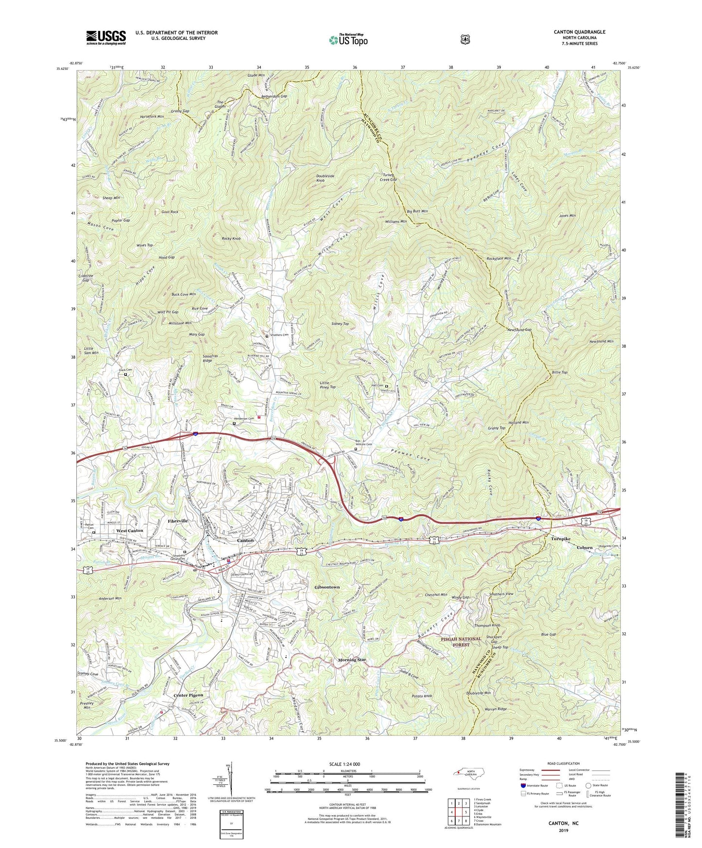
Canton North Carolina US Topo Map
Couldn't load pickup availability
Also explore the Canton Forest Service Topo of this same quad for updated USFS data
2022 topographic map quadrangle Canton in the state of North Carolina. Scale: 1:24000. Based on the newly updated USGS 7.5' US Topo map series, this map is in the following counties: Haywood, Buncombe. The map contains contour data, water features, and other items you are used to seeing on USGS maps, but also has updated roads and other features. This is the next generation of topographic maps. Printed on high-quality waterproof paper with UV fade-resistant inks.
Quads adjacent to this one:
West: Clyde
Northwest: Fines Creek
North: Sandymush
Northeast: Leicester
East: Enka
Southeast: Dunsmore Mountain
South: Cruso
Southwest: Waynesville
This map covers the same area as the classic USGS quad with code o35082e7.
Contains the following named places: Beaverdam Church, Beaverdam Creek, Beaverdam Gap, Beaverdam School, Big Briar Cove, Big Butt Mountain, Billie Top, Blue Gap, Bon - A - Venture Cemetery, Bowen Branch, Buck Cove Mountain, Buckeye Cove, Burnett Cove, Calvary Church, Canton, Canton Fire Department, Canton Junior High School, Canton Plaza, Canton Police Department, Canton Post Office, Canton Reservoir, Center Pigeon, Center Pigeon Fire Department, Chestnut Mountain, Clark Chapel Cemetery, Coburn, Coffee Branch, Crabtree Gap, Doubleside Knob, Doubletop Mountain, Dutch Cove Church, Dutch Cove Creek, Fibreville, Fishers Lake, Frenchmans Creek Mall, Garden Creek, Gibsontown, Glade Mountain, Goat Rock, Grassy Gap, Grassy Top, Hall Cemetery, Harmony Grove Church, Haywood County Emergency Medical Services Medic 4, Haywood County Emergency Medical Services Medic 6, Haywood County Rescue Squad, Haywood Memorial Church, Henderson Cemetery, High Street Church, Hipps Cove, Holland Mountain, Hood Gap, Horsefork Mountain, Jo Ab Branch, Jodie B Cove, Jones Mountain, Little Piney Top, Long Branch, Long Branch Church, Lukes Cove, Maple Grove Church, Mary Gap, Mason Cove, Millstone Mountain, Mingus Branch, Morning Star, Mount View Golf Course, Murray Branch, Newfound Gap, North Canton Church, North Canton Fire Department - Station 13, North Canton School, North Hominy Creek, Oak Grove Church, Patton Cemetery, Patton School, Peepeye Cove, Peewee Cove, Pennsylvania Avenue School, Piney Grove Church, Pinnacle View Church, Pisgah High School, Plains Church, Plott Farm Addition, Poplar Gap, Potato Knob, Rhinehart Cove, Rhodarmer Cove, Rice Cove, Rice Cove Creek, Ridgeway Church, Rockwood Church, Rocky Cove, Rocky Knob, Rockyface Church, Rockyface Mountain, Rough Creek, Sassafras Ridge, Sheep Mountain, Sheep Top, Shuckpen Gap, Sidney Top, Smathers Cemeteries, Smathers Cemetery, Smathers View, Stamey Cove, Stamey Cove Branch, Sunnypoint Church, The Glades, Thickety Creek, Thompson Knob, Town of Canton, Township of Beaverdam, Turkey Creek Gap, Turnpike, Wade Branch, Warren Ridge, Welcome Hill Church, West Canton, West Canton Census Designated Place, West Cove, Williams Mountain, Willis Cove, Wilson Cove, Windy Gap, Wines Top, Wolf Pit Gap, Worley Cove, WPTL-AM (Canton), WWIT-AM (Canton)