MyTopo
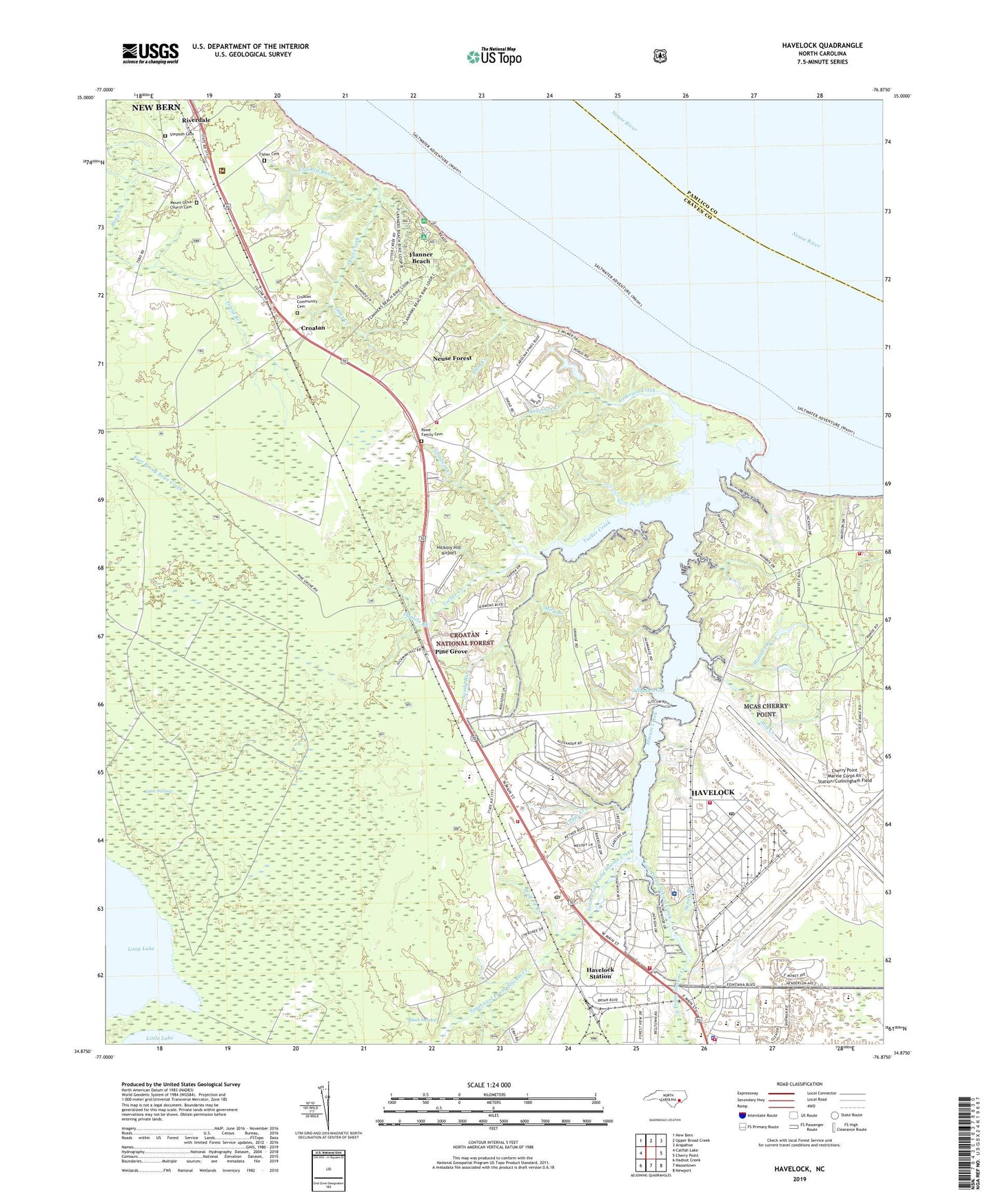
Havelock North Carolina US Topo Map
Couldn't load pickup availability
Also explore the Havelock Forest Service Topo of this same quad for updated USFS data
2022 topographic map quadrangle Havelock in the state of North Carolina. Scale: 1:24000. Based on the newly updated USGS 7.5' US Topo map series, this map is in the following counties: Craven, Pamlico. The map contains contour data, water features, and other items you are used to seeing on USGS maps, but also has updated roads and other features. This is the next generation of topographic maps. Printed on high-quality waterproof paper with UV fade-resistant inks.
Quads adjacent to this one:
West: Catfish Lake
Northwest: New Bern
North: Upper Broad Creek
Northeast: Arapahoe
East: Cherry Point
Southeast: Newport
South: Masontown
Southwest: Hadnot Creek
This map covers the same area as the classic USGS quad with code o34076h8.
Contains the following named places: Alligator Gut, Anderson Creek, Black Swamp, Brice Creek Church, Britthaven of Havelock, Carolina Pines, Cedar Creek, Cherry Point Baptist Church, Cherry Point Church of Christ, Cherry Point Marine Base Mobile Home Park, Cherry Point Marine Corps Air Station/Cunningham Field, Cherry Point Post Office, City of Havelock, Commercial Shopping Center, Croatan, Croatan Community Cemetery, Croatan Game Land, Croatan Lookout Tower, Croatan Ranger District Office, Crooked Run, Dam Creek, Daniels Branch, Dogwood Farm Airport, East Prong Slocum Creek, First United Methodist Church, Fisher Cemetery, Flanner Beach, Gateway Shopping Center, Goodwin Creek, Greenfield Mobile Home Park, Greenfields Heights, Gum Swamp, Hancock Village, Havelock, Havelock - Craven County Public Library, Havelock City Hall, Havelock Fire and Rescue Department, Havelock Manor, Havelock Mobile Court, Havelock Park, Havelock Police Department, Havelock Post Office, Havelock Shopping Center, Havelock Station, Havelock Wastewater Treatment Plant, Hickory Hill Airport, Hunters Branch, Jackson Mobile Home Park, Joe Hughes Pond, Joe Hughes Pond Dam, Ketner Heights, Lake Road Baptist Church, Manteo, Marine Corp Air Station Cherry Point Fire and Emergence Services Department Station 2, Marine Corp Air Station Cherry Point Fire and Emergency Services Department Station 1, Marine Corp Air Station Cherry Point Fire Department Station 3, Marine Corps Air Station Cherry Point, Marman Terrace, McCotter Boulevard Baptist Church, Mill Creek, Miry Branch, Mount Olive Church Cemetery, Neuse Forest, Neuse Forest Census Designated Place, Neuse River Recreation Site, Norris Mobile Home Village, Otter Creek, Pine Grove, Riverdale, Rowe Family Cemetery, Saint Timothy Lutheran Church, Sanderson Mobile Home Park, Sandy Branch, Sandy Run, Sherwood Forest, Simpson Cemetery, Slocum Creek, Slocum Village Shopping Center, Slocun Village, Southwest Prong Slocum Creek, Township 6, Township Six Fire Department, Township Six Fire Department Station 2, Tucker Creek, United States Naval Hospital Cherry Point, US Military Police, WCPQ-AM (Havelock), Westbrooke Shopping Center, WMSQ-FM (Havelock), Wolf Pit Branch, WSMQ-FM (Havelock), ZIP Codes: 28532, 28533