MyTopo
Kings Mountain North Carolina US Topo Map
Couldn't load pickup availability
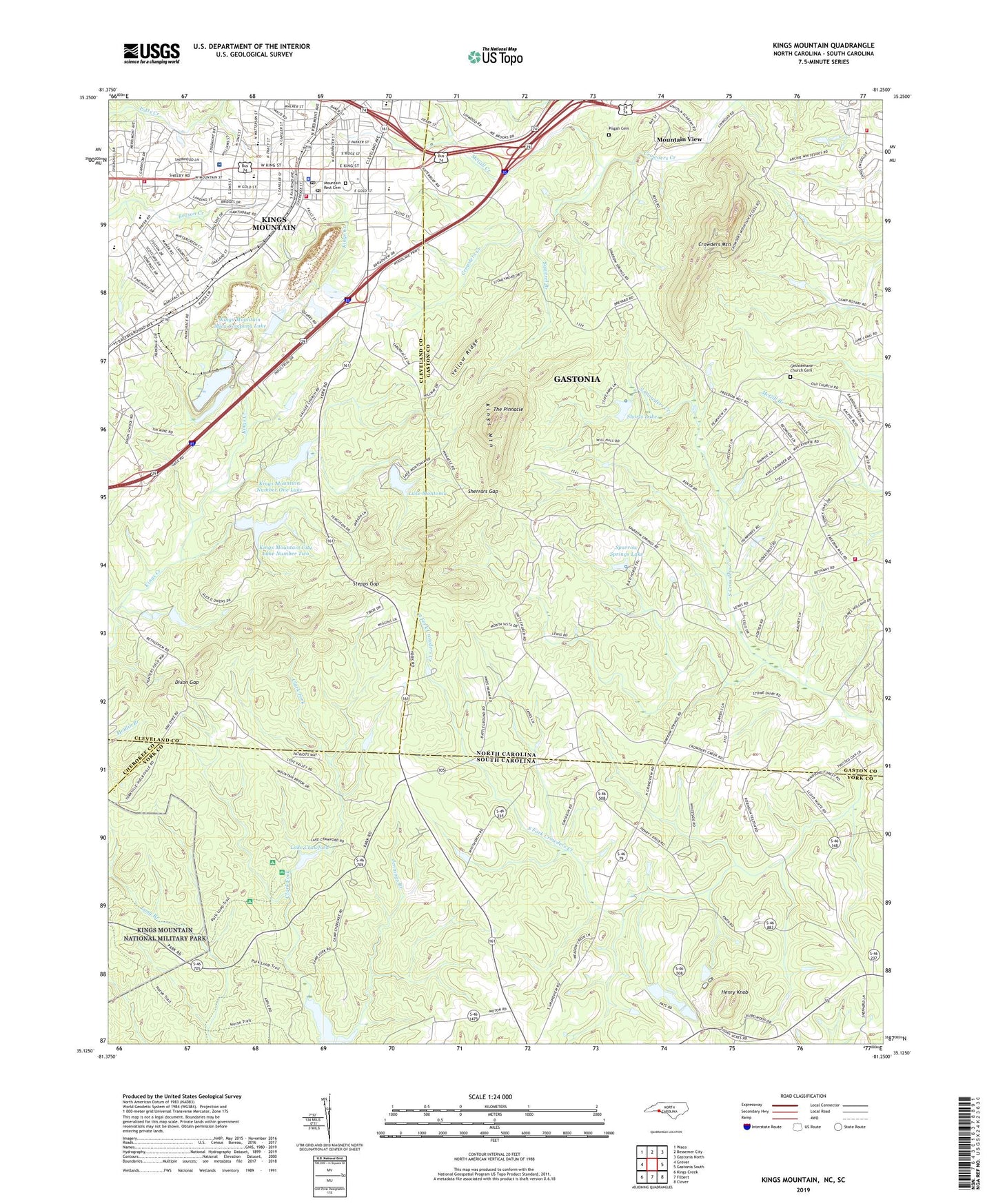
2022 topographic map quadrangle Kings Mountain in the states of North Carolina, South Carolina. Scale: 1:24000. Based on the newly updated USGS 7.5' US Topo map series, this map is in the following counties: Gaston, York, Cleveland, Cherokee. The map contains contour data, water features, and other items you are used to seeing on USGS maps, but also has updated roads and other features. This is the next generation of topographic maps. Printed on high-quality waterproof paper with UV fade-resistant inks.
Quads adjacent to this one:
West: Grover
Northwest: Waco
North: Bessemer City
Northeast: Gastonia North
East: Gastonia South
Southeast: Clover
South: Filbert
Southwest: Kings Creek
Contains the following named places: Barnes Auditorium, Boyce Memorial Associate Reformed Presbyterian Church, Camp Rotary, Carson Memorial Church, Central Middle School, Central United Methodist Church, Chapel School, Cherokee Street Church, City of Kings Mountain, Cleveland County Lifesaving and Rescue Squad, Crowders Mountain, Crowders Mountain State Park, Crowders Mountain Volunteer Fire and Rescue Station 1, Davidson School, Deal Park, Dixon Gap, East Elementary School, Executive Club Dam, Executive Club Lake, Fairview School, Faith Church, First Baptist Church of Kings Mountain, Foote Mineral Reservoir, Foote Mineral Reservoir Dam, Foote Mineral Tailings Pond, Foote Mineral Tailings Pond Dam, Galilee Methodist Church, Gastonia City Fire Department Station 8, Gethsemane Church, Gethsemane Church Cemetery, Henry Knob, Hill Top Open Door Mission, J S Mauney Memorial Library, Jennings Branch, Kings Mountain, Kings Mountain Baptist Church, Kings Mountain City Lake Number Two, Kings Mountain Crushed Rock Quarry, Kings Mountain Fire Department Main Station, Kings Mountain Fire Department Station 2, Kings Mountain High School, Kings Mountain Hospital, Kings Mountain Mica Company Dam, Kings Mountain Mica Company Lake, Kings Mountain Number One Dam, Kings Mountain Number One Lake, Kings Mountain Police Department, Kings Mountain Post Office, Kings Mountain State Park, Kings Mountain Township 4, Lake Crawford, Lake Crawford Dam D-3639, Lake Montonia, Lake Montonia Dam, Lake York, Laurel Woods, Leslie Mills, Little Theater, Love Valley, Love Valley Church, Macedonia Church, McGill Creek, Mount Olive Church, Mountain Rest Cemetery, Mountain View, Mountain View Golf Course, Oak View Church, Pisgah Cemetery, Saint Matthews Lutheran Church, Sherrars Gap, Shorts Lake, Shorts Lake Dam, Sparrow Springs Lake, Sparrow Springs Lake Dam, Squirrel Branch, Stepps Gap, The Pinnacle, Township of Crowders Mountain, Trinity Church, Unity Church, Upper Whiteside Dam, West Elementary School, West Palm Acres, WZXI-FM (Gastonia), Yellow Ridge