MyTopo
Lincolnton West North Carolina US Topo Map
Couldn't load pickup availability
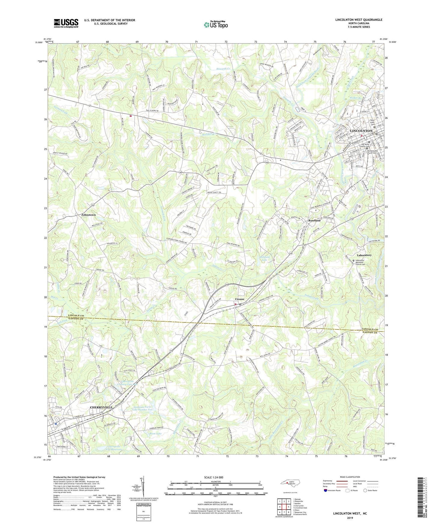
2022 topographic map quadrangle Lincolnton West in the state of North Carolina. Scale: 1:24000. Based on the newly updated USGS 7.5' US Topo map series, this map is in the following counties: Lincoln, Gaston. The map contains contour data, water features, and other items you are used to seeing on USGS maps, but also has updated roads and other features. This is the next generation of topographic maps. Printed on high-quality waterproof paper with UV fade-resistant inks.
Quads adjacent to this one:
West: Cherryville
Northwest: Banoak
North: Reepsville
Northeast: Maiden
East: Lincolnton East
Southeast: Gastonia North
South: Bessemer City
Southwest: Waco
This map covers the same area as the classic USGS quad with code o35081d3.
Contains the following named places: Anthony Grove Church, Antioch Church, Baptist Church Fellowship Building, Battleground Elementary School, Beam Lake, Beam Lake Dam, Bethphage Church, Calvary Church, Carolina, Cherry Hill Center, Cherryville City Pool, Cherryville City Reservoir, Cherryville City Reservoir Dam, Cherryville Country Club Lake, Cherryville Country Club Lake Dam, Cherryville Plaza, Cherryville Police Department, Church of God, Clark Creek, Crouse, Crouse Census Designated Place, Crouse Elementary School, Crouse Post Office, Crouse Volunteer Fire Department, Daniels, East School, First Presbyterian Church, First Wesleyan Church, Gainsville Church, Gordon Crowell Memorial Hospital, Hinter United Methodist Church, Hollifield Lake, Hollifield Lake Dam, Howards Creek, Howards Creek School, Howard's Creek Volunteer Fire Department Substation, Hoyles Store, Johnstown, Kenwood Park, Laboratory, Laboratory Methodist Church Cemetery, Landers Chapel, Leonard Fork, Leonards Fork Church, Lick Fork, Lincoln Airport, Lincoln Avenue Baptist Church, Lincoln County Lifesaving Crew, Lincolnton, Lincolnton Fire Department, Lincolnton High School, Lincolnton Junior High School, Lincolnton Post Office, Lincolnton Water Treatment Plant, Lithia Branch, Little Beaverdam Creek, Love Memorial Elementary School, Massopoag Church, Mill Creek, Oaklawn Elementary School, Old Methodist Church Cemetery, Old White Church Cemetery, Our Savior Episcopal Church, Park Elementary School, Pentecostal Holiness Church, Pleasant Grove Church, Polkadot, Rhyne Heights Methodist Church, River View Church, Rockdam Creek, Roseland, Saint Dorothys Catholic Church, Saint Lukes Cemetery, Saint Lukes Lutheran Church, Saint Marks Church, Saint Pauls Church, Smiths Store, Stagecoach House, Sunbeam Farm, Sunbeam Farm Lake Dam Number Two, Sunbeam Farm Lake Number Two, Tanyard Creek, Township of Howards Creek, Walker Branch, WCSL-AM (Cherryville), Webbs Chapel, West Lincolnton Church, White Pines, WLON-AM (Lincolnton), ZIP Codes: 28033, 28092