MyTopo
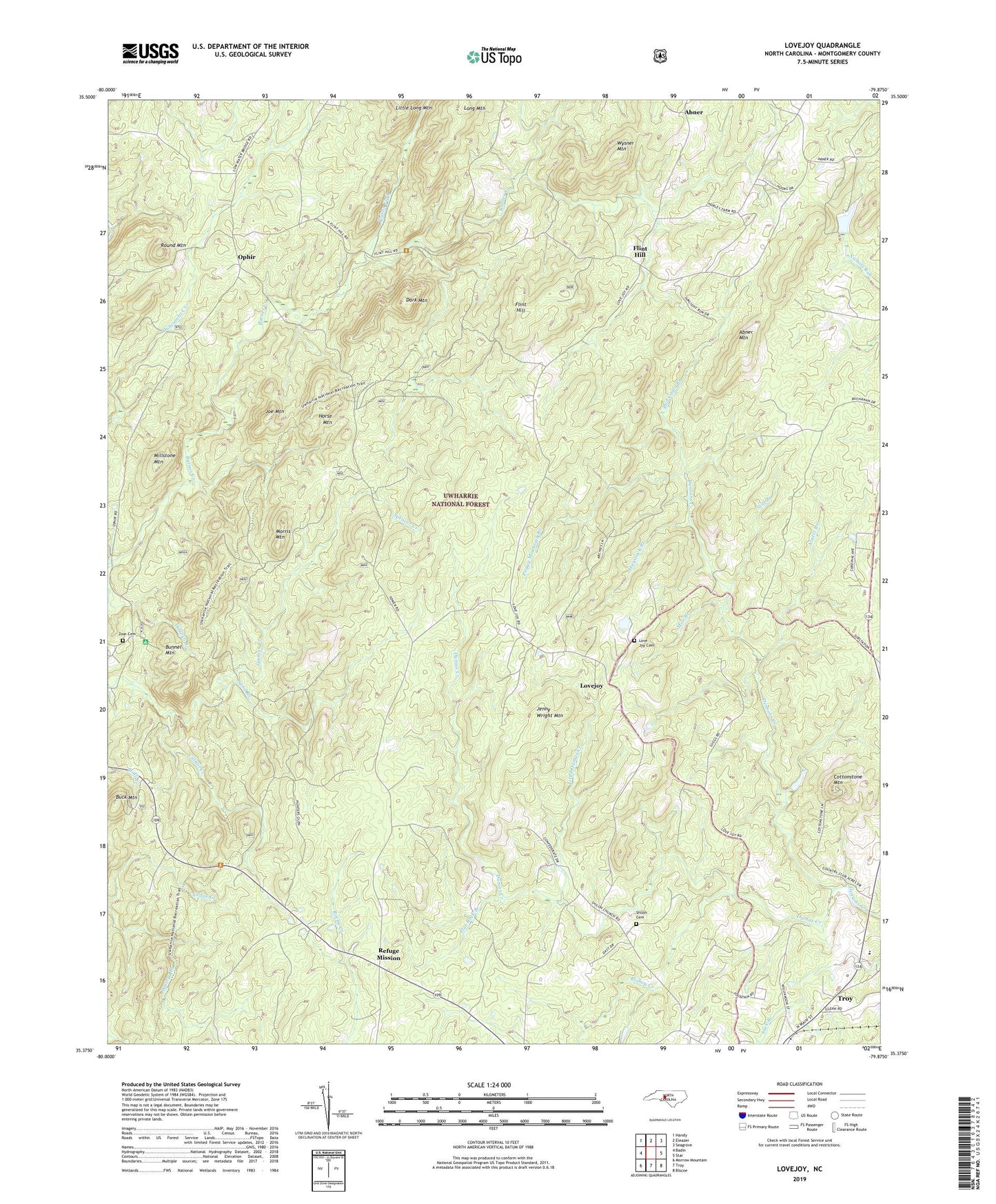
Lovejoy North Carolina US Topo Map
Couldn't load pickup availability
Also explore the Lovejoy Forest Service Topo of this same quad for updated USFS data
2022 topographic map quadrangle Lovejoy in the state of North Carolina. Scale: 1:24000. Based on the newly updated USGS 7.5' US Topo map series, this map is in the following counties: Montgomery. The map contains contour data, water features, and other items you are used to seeing on USGS maps, but also has updated roads and other features. This is the next generation of topographic maps. Printed on high-quality waterproof paper with UV fade-resistant inks.
Quads adjacent to this one:
West: Badin
Northwest: Handy
North: Eleazer
Northeast: Seagrove
East: Star
Southeast: Biscoe
South: Troy
Southwest: Morrow Mountain
This map covers the same area as the classic USGS quad with code o35079d8.
Contains the following named places: Abner, Abner Mountain, Arnett Branch, Bishop Creek, Buck Mountain, Buck Mountain Lookout Tower, Bud Cagle Branch, Bunnel Mountain, Cattail Creek, Cottonstone Mountain, Dark Mountain, Dumas Creek, East Morris Mountain Hunt Camp, Flat Rock Branch, Flint Hill, Flint Hill Church, Flint Hill School, Haystack Branch, Hewitt Pond, Hewitt Pond Dam, Hogpen Branch, Horse Mountain, Immer, Jenny Wright Mountain, Joe Mountain, Little Dumas Creek, Lomax Memorial Church, Long Mountain, Love Joy Cemetery, Love Joy Methodist Church, Lovejoy, Macedonia Church, McNair Lake, McNair Lake Dam, Mile Branch, Millstone Mountain, Morris Mountain, Mount Olivet Church, Ophir, Ophir Methodist Episcopal Church South, Ophir School, Panther Branch, Peggy Mountain Branch, Poison Fork, Refuge Mission, Round Mountain, Sand Branch, Shiloh, Shiloh Cemetery, Shiloh Methodist Church, State Prison Camp 804, Still Branch, Township of Ophir, Uwharrie Jeep Trail, Uwharrie National Forest, West Morris Mountain Camp, Wysner Mountain, Zoar Cemetery, Zoar Church, ZIP Code: 27371