MyTopo
Rainbow Springs North Carolina US Topo Map
Couldn't load pickup availability
Also explore the Rainbow Springs Forest Service Topo of this same quad for updated USFS data
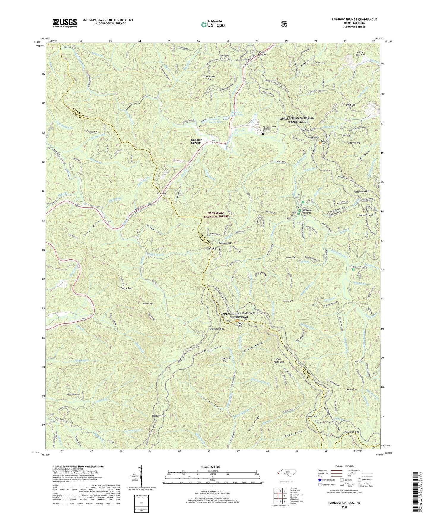
2022 topographic map quadrangle Rainbow Springs in the state of North Carolina. Scale: 1:24000. Based on the newly updated USGS 7.5' US Topo map series, this map is in the following counties: Macon, Clay. The map contains contour data, water features, and other items you are used to seeing on USGS maps, but also has updated roads and other features. This is the next generation of topographic maps. Printed on high-quality waterproof paper with UV fade-resistant inks.
Quads adjacent to this one:
West: Shooting Creek
Northwest: Topton
North: Wayah Bald
Northeast: Franklin
East: Prentiss
Southeast: Dillard
South: Hightower Bald
Southwest: Macedonia
This map covers the same area as the classic USGS quad with code o35083a5.
Contains the following named places: Angel Mountain, Ascension Chapel Episcopal Graveyard, Barnards Creek, Barrett Branch, Bear Gap, Bear Knob, Bearpen Creek, Bee Tree Knob, Beech Gap, Bell Knob, Big Indian Creek, Big Kitchens Ridge, Big Laurel, Big Laurel Branch, Big Scaly, Big Shoal Branch, Black Branch, Black Creek, Black Gap, Blackwell Gap, Blackwell Ridge, Brushy Mountain, Bryson Branch, Buck Creek, Buck Creek Barrens, Buck Knob, Bull Cove, Bullscrape Branch, Buzzard Knob, Byrd Gap, Byrd Hollows, Case Knife Gap, Cherry Cove, Chestnut Branch, Chestnut Ridge, Chimney Rock Branch, Clear Spring Branch, Coleman Gap, Collary Cove, Courthouse Bald, Cowl Cove, Crawford Flats, Curtis Creek, Davenport Branch, Deadening Knob, Deep Gap, Deep Gap Branch, Deep Gap Campground, Deep Gap Primitive Campground, Devils Prong, Dismal Cove, Doe Knob, Factory Branch, Fairfield Ridge, Firescald Ridge, Fork Ridge, Frank Gap, Frog Mountain, Glade Branch, Glassmine Gap, Grassy Gap, Gulf Fork, Hogan Cove, Hogan Ridge, Holden Cove, Hurricane Creek, Hurricane Top, Indian Ridge, Jake Branch, Jake Ridge, Joel Cove, John Branch, John Gap, Johnson Branch, Kilby Creek, Kilby Gap, Kimsey Bald, Kimsey Creek, Kimsey Creek Recreation Site, Kitchens Knob, Kitty Ridge, Laurel Branch, Little Buck Creek, Little Indian Creek, Little Kitchens Ridge, Little Lyman Prong, Little Mountain, Little Rock Branch, Loggy Branch, Long Branch, Lower Trail Ridge, Marbleyard Ridge, Middle Gap, Middle Ridge, Middle Trail Ridge, Milksick Knob, Mooney Creek, Moore Creek, Moore Creek Lower, Moore Creek Lower Lake, Moore Creek Upper, Moore Creek Upper Lake, Mossy Back Gap, Mountainside Branch, Muskrat Creek Shelter, Nichols Branch, Nova Scotia Branch, Park Creek, Park Gap, Pat Stable Branch, Pat Stable Ridge, Penland Gap, Pine Mountain, Rainbow Springs, Rattlesnake Gap, Rattlesnake Knob, Ravenrock Ridge, Riley Cove, Riley Knob, Rock Gap, Rock Gap Shelter, Rocky Cove Knob, Rough Cove, Runaway Gap, Runaway Knob, Runaway Ridge, Sassafras Gap, Scaly Ridge, Scream Ridge, Siler Creek, Standing Indian Recreation Site, Standing Indian Shelter, Sugar Cove, Swinging Lick Gap, Thomas Branch, Township of Cartoogechaye, Trough Branch, Upper Trail Ridge, Wallace Gap, Water Spout Branch, Wateroak Creek, Wateroak Gap, Whiteoak Bottoms, Whiteoak Stamp, Winding Stair Gap, Wyant Branch, Yellow Mountain