MyTopo
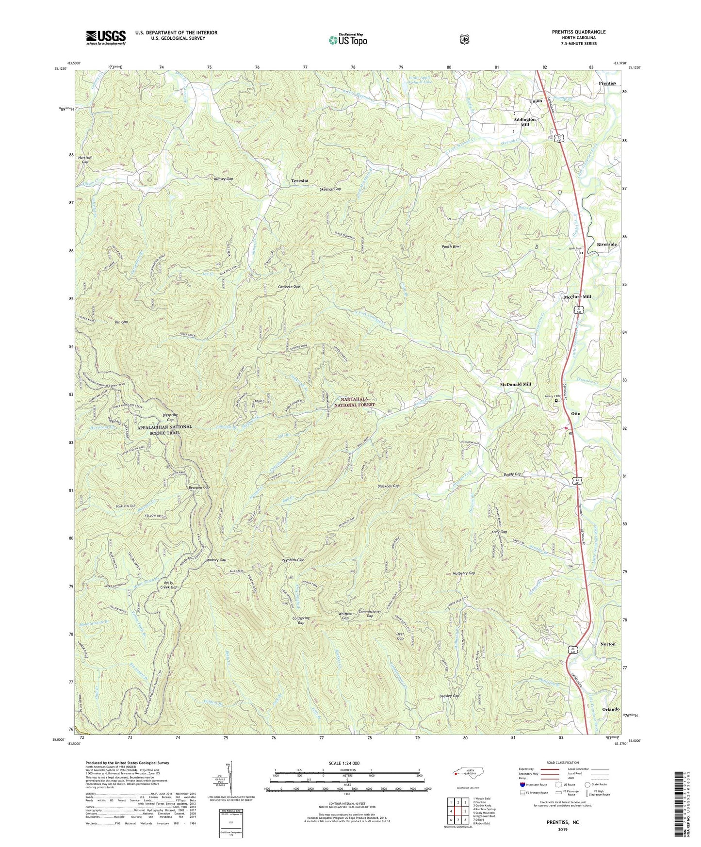
Prentiss North Carolina US Topo Map
Couldn't load pickup availability
Also explore the Prentiss Forest Service Topo of this same quad for updated USFS data
2022 topographic map quadrangle Prentiss in the state of North Carolina. Scale: 1:24000. Based on the newly updated USGS 7.5' US Topo map series, this map is in the following counties: Macon, Clay. The map contains contour data, water features, and other items you are used to seeing on USGS maps, but also has updated roads and other features. This is the next generation of topographic maps. Printed on high-quality waterproof paper with UV fade-resistant inks.
Quads adjacent to this one:
West: Rainbow Springs
Northwest: Wayah Bald
North: Franklin
Northeast: Corbin Knob
East: Scaly Mountain
Southeast: Rabun Bald
South: Dillard
Southwest: Hightower Bald
This map covers the same area as the classic USGS quad with code o35083a4.
Contains the following named places: Addington Mill, Albert Mountain, Albert Mountain Fire Tower, Allen Mountain, Allison Creek, Anderson Branch, Andy Gap, Asbury Cemetery, Asbury Church, Ash Flat Branch, Ball Creek, Bates Branch, Bates Mountain, Battle Branch, Bearpen Gap, Bearpen Mountain, Beasley Gap, Betty Creek Gap, Big Butt, Bigspring Gap, Bigspring Gap Shelter, Black Mountain, Black Mountain Branch, Black Mountain Church, Blackoak Gap, Blaine Knob, Bradley Branch, Brushy Ridge, Buddy Gap, Calvary Church, Camprock Branch, Carpenters Branch, Carrol Knob, Carter Gap Appalachian Trail Shelter, Cedar Cliff Mountain, Chimney Knob, Cloer Branch, Coldspring Gap, Commissioner Gap, Coweeta Church, Coweeta Creek, Coweeta Experiment Forest Headquarters, Coweeta Experiment Station, Coweeta Gap, Coweeta Hydrologic Laboratory, Craig Mountain, Cunningham Creek, Deer Gap, Doubletop Mountain, Dowdle Branch, Downs Mountain, Dryman Fork, Falls Branch, Fork Ridge, Foster Knob, Foster Ridge, Gage Trail, Gillespie Church, Granny Green Mountain, Gulf Branch, Hannah Mountain, Harrison Gap, Henson Creek, Hickory Knoll Creek, High Knob, Hoglot Branch, Howard Branch, Hurricane Creek Trail, James Creek, Kate Knob, Kimsey Gap, Lee Creek, Little Chimney Knob, Little Mountain, Little Pinnacle, Little Ridgepole Mountain, Long Ridge, Maidens Chapel, McClure Mill, McDonald Mill, Mill Branch, Mill Knob, Mooney Branch, Mooney Gap, Morrison Church, Mulberry Church, Mulberry Creek, Mulberry Gap, Nantahala Game Lands, Newman Chapel, North Fork Coweeta Creek, North Fork Skeenah Creek, Norton, Norton Branch, Orlando, Otto, Otto Elementary School, Otto Fire and Rescue, Otto Post Office, Pickens Nose, Pin Gap, Pine Mountain, Pine Ridge, Pinnacle Branch, Pinnacle Mountain, Pleasant Hill Church, Prentiss, Prentiss Church, Punch Bowl, Reynolds Gap, Rich Knob, Riverside, Rock Branch, Rockhouse Knob, Rockyface Mountain, Rush Cemetery, Sanders Knob, Sassafras Ridge, Scream Ridge, Shope Fork, Skeenah Creek, Skeenah Gap, Snakeden Knob, Soco Ridge, South Fork Skeenah Creek, Steeltrap Knob, Stewart Trail, Teresita, Tessentee Creek, Thompson Prong, Timber Ridge, Township of Smithbridge, Trail Ridge, Union, Vitale Apple Orchard Dam, Vitale Apple Orchard Lake, Waterloo Branch, Wildcat Branch, Wolfpen Gap, Yellow Bald, Yellow Patch Branch, ZIP Code: 28763