MyTopo
Gold Beach Oregon US Topo Map
Couldn't load pickup availability
Also explore the Gold Beach Forest Service Topo of this same quad for updated USFS data
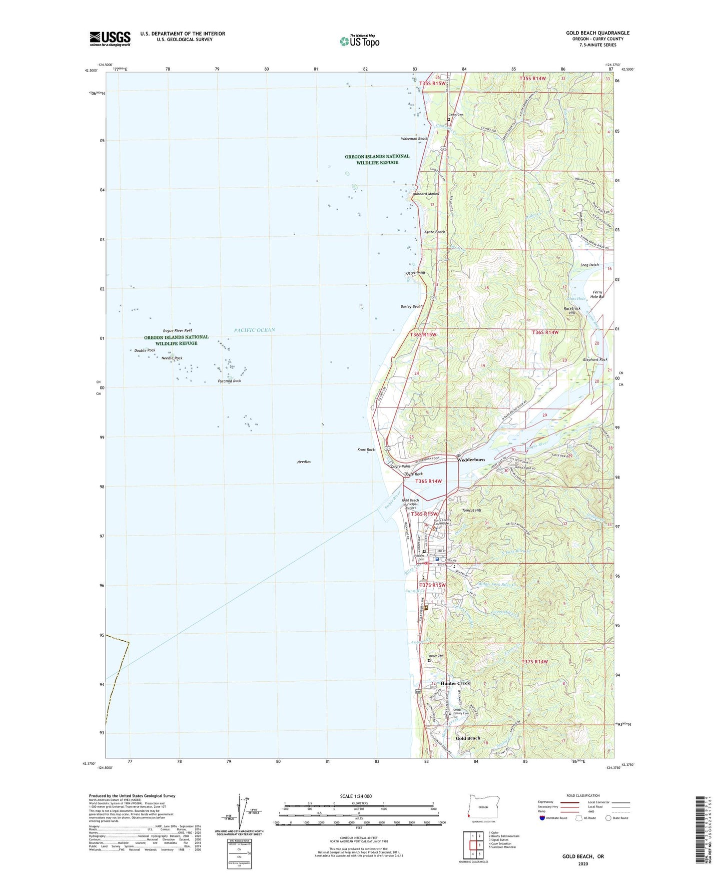
2023 topographic map quadrangle Gold Beach in the state of Oregon. Scale: 1:24000. Based on the newly updated USGS 7.5' US Topo map series, this map is in the following counties: Curry. The map contains contour data, water features, and other items you are used to seeing on USGS maps, but also has updated roads and other features. This is the next generation of topographic maps. Printed on high-quality waterproof paper with UV fade-resistant inks.
Quads adjacent to this one:
North: Ophir
Northeast: Brushy Bald Mountain
East: Signal Buttes
Southeast: Sundown Mountain
South: Cape Sebastian
This map covers the same area as the classic USGS quad with code o42124d4.
Contains the following named places: Agate Beach, Antone Creek, Barley Beach, Big Prairie, Buena Vista State Park, City of Gold Beach, Collier H Buffington Memorial Park, Cummins Creek, Cunniff Creek, Curry County Courthouse, Curry County Fairgrounds Outdoor Stage, Curry County Outdoor Arena, Curry County Public Health Department, Curry County Rodeo and Fairgrounds, Curry County Sheriff's Office, Curry General Hospital, Curry Historical Society Museum, Curry Public Library District, Dean Creek, Double Rock, Doyle Point, Doyle Rock, East Fork Cunniff Creek, Edson Creek, Elephant Rock, Ferry Hole Bar, Flood Creek, Fort Miner, Geisel Cemetery, Geisel Monument State Park, Gold Beach, Gold Beach Boat Launch, Gold Beach City Hall, Gold Beach Division, Gold Beach High School, Gold Beach Municipal Airport, Gold Beach Municipal Court, Gold Beach Police Department, Gold Beach Post Office, Gold Beach Public Works, Gold Beach Ranger Station, Gold Beach Sewage Treatment Plant, Gold Beach Volunteer Fire Department, Hubbard Mound, Hunter Creek, Indian Creek, Indian Creek Campground, Johns Hole, Jot's Resort, Jot's Resort Boat Ramp, Knox Rock, Knoxville, Krambeal Creek, Lynch Creek, Middle Fork Riley Creek, Miller Creek, Needle Rock, Needles, North Fork Riley Creek, Northwest Rock, Otter Point, Otter Point State Park, Pioneer Cemetery, Pocket Park, Port of Gold Beach Boat Ramp, Pyramid Rock, Racetrack Hill, Riley Creek, Riley Creek Elementary School, Rogue Cemetery, Rogue Playhouse Theatre, Rogue River, Rogue River Reef, Saint Charles Catholic Church, Saunders Creek, Scott Creek, Seventh Day Adventist Church, Smith Family Cemetery, Snag Patch, South Beach Park, South Fork Riley Creek, Tomcat Hill, Turner Creek, Wakeman Beach, Wedderburn, Wedderburn Census Designated Place, Wedderburn Post Office, Wedderburn Sanitary District Wastewater Treatment Plant, West Fork Cunniff Creek