MyTopo
John Day Oregon US Topo Map
Couldn't load pickup availability
Also explore the John Day Forest Service Topo of this same quad for updated USFS data
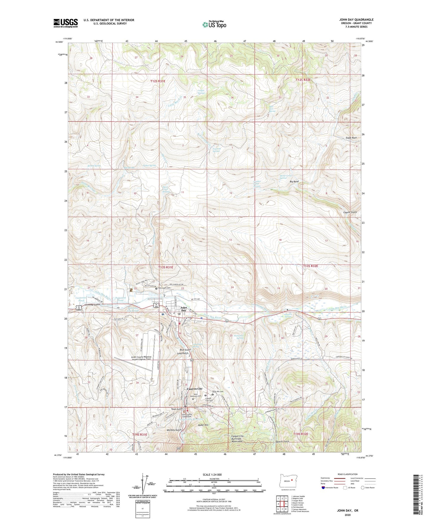
2023 topographic map quadrangle John Day in the state of Oregon. Scale: 1:24000. Based on the newly updated USGS 7.5' US Topo map series, this map is in the following counties: Grant. The map contains contour data, water features, and other items you are used to seeing on USGS maps, but also has updated roads and other features. This is the next generation of topographic maps. Printed on high-quality waterproof paper with UV fade-resistant inks.
Quads adjacent to this one:
West: Mount Vernon
Northwest: Johnson Saddle
North: Magone Lake
Northeast: Cougar Rock
East: Castle Creek
Southeast: Pine Creek Mountain
South: Canyon Mountain
Southwest: Fall Mountain
This map covers the same area as the classic USGS quad with code o44118d8.
Contains the following named places: Benson Spring, Big Bend, Big Springs, Blue Gulch, Blue Mountain Alternative High School, Blue Mountain Hospital, Blue Mountain Ranger District, Blue Mountain Ranger Station, Boot Hill Cemetery, Canyon City, Canyon City Cemetery, Canyon City Hall, Canyon City Post Office, Canyon City Public Works Department Office, Canyon City Reservoir, Canyon City Volunteer Fire Department, Canyon Creek, Carpenter Pond, Chimney Gulch, City of John Day, Coalpit Springs, Coyote Gulch, Davis Creek, Davis Creek Springs, Department of Motor Vehicles John Day, Dog Creek, Eagle Rock, Fourmile Springs, Gleason Spring, Grant County Fairgrounds, Grant County Fairgrounds Outdoor Arena, Grant County Health Office and Family Planning Clinic, Grant County Historical Museum, Grant County Jail, Grant County Library, Grant County Ranch and Rodeo Museum, Grant County Regional Airport/Ogilvie Field, Grant County Sheriff's Office, Grant County Trial and Justice Courthouse, Grant Union High School, Gunther Cabin Springs, Hacheney Spring, Humbolt Elementary School, John Day, John Day City Hall, John Day Fire Department, John Day Police Department, John Day Post Office, John Day Public Works Department Main Office, John Day Sewage Treatment Plant, John Long Placer Mine, Kam Wah Chung State Heritage Site, Kam Wah Chung State Park, KJDY-AM, Little Dog Creek, Little Pine Creek, Long Gulch, Long Gulch Springs, Luce Ditch, Malheur National Forest Headquarters, Marysville Placer, Marysville School, Museum of Horse Drawn Vehicles, Old Humbolt Diggings, Oregon State Police Department - John Day Worksite, Parker Spring, Patterson Pond, Pine Tree Spring, Potato Patch Mine, Quartz Gulch, Rebel Hill, Rest Lawn Cemetery, Saint Andrews Cemetery, San Juan Log Ponds, Sheep Corral Springs, Town Gulch, Town of Canyon City, Trowbridge Ditch, Trowbridge Ranch, Valley View Seventh Day Adventist Christian School, Ward Mine, West Fork Grub Creek, Whiskey Gulch, ZIP Code: 97845